Ucluelet, British Columbia 作者: 来源: 发布时间:2021-12-09
I.Population and Area
-Area
•Land: 6.81 km2 (2.63 sq mi)
•Water: 0.32 km2 (0.12 sq mi)
-Elevation: 20 m (70 ft)
-Population (2016)
-Total: 1,717
-Density: 264.5/km2 (685/sq mi)

II.Natural Geography (environment and resources)
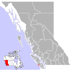
-Ucluelet is a district municipality (population 1,717) on the Ucluelet Peninsula on the west coast of Vancouver Island in British Columbia, Canada. Ucluelet means "people of the safe harbour" in the indigenous Nuu-chah-nulth (Nootka) language. As of 2016, its population was 1,717, a 5.5% increase from 1,627 in 2011.
-Ucluelet has an oceanic climate (Köppen Cfb) of the type found in Ireland with mild, rainy winters and cool summers owing to its coastal location. As such, temperatures above 30 °C (86.0 °F) and below −10 °C (14.0 °F) are rare. Precipitation is high, averaging around 3,350 mm (132 in) per year, with most of it concentrated in the winter months. Even so, precipitation is significant in all months with no month averaging below 70 mm (3 in) of precipitation. Although it has an average snowfall of 32.4 cm (12.8 in), the median is 0, meaning over 50% of years do not experience a single snowfall; this makes this climate unique in Canada.
III.ECONOMY
-Average Hourly Rate in Ucluelet, British Columbia: C$23.20
-Average Salary in Ucluelet, British Columbia: C$48k

-Website: https://www.payscale.com/research/CA/Location=Ucluelet-British-Columbia/Salary
IV.Industrial Characteristics
-Like its neighbour Tofino, Ucluelet has made the transition from a resource-based economy to a year-round tourism-based economy. The Pacific Rim Visitor Centre is now the second-most-visited Tourism Centre, after Victoria, on Vancouver Island, and on average receives 90,000 visitors from around the world to the Pacific Rim National Park, Ucluelet and Tofino area.
-Tourist activities include surfing, stand-up paddle board, fishing, whale watching, bear watching, kayaking, canoeing, camping, hiking, biking, swimming, and beachcombing. Storm watching is also an activity during the November to March season.
-Activities
•The Wild Pacific Trail begins near the mouth of Ucluelet Inlet at Amphitrite Point Lighthouse and travels north along the open Pacific coastline through Big Beach Park to the bike path just outside Ucluelet. The final section will extend the trail to Halfmoon Bay in the Pacific Rim National Park Reserve. The trail is accessible to all ages and abilities, even wheelchairs in certain areas. No bikes, horses or motorized vehicles are permitted on the park’s beaches or trails. The hiking trails are designed to let visitors experience the shoreline while preventing damage to the fragile environment.
•Various marine tours are available including sea kayaking, canoeing in the inlet, whale and wildlife watching. There has been an ongoing interest in sport fishing out of Ucluelet and there are many chartered sports fishing options in town. Surfing has become a popular activity among tourists and locals alike. In the summer months, surfers gather along Florencia Bay, Wickaninnish Beach and Long Beach in the Pacific Rim National Park Reserve.
•Mt. Ozzard, which hosts the Coast Guard Marine Communication and Traffic Services (MCTS) surveillance radar dome and various other communications towers, has a service road that is gated at the bottom. Despite the gate, the road to the summit is accessible to hikers and all-terrain vehicles. The MCTS centre at Amphitrite Point was closed in May 2015 and its services relocated to Prince Rupert.
V.Attractions
1.Ucluelet Aquarium
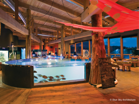
-The Ucluelet Aquarium is a non-profit public aquarium in Ucluelet, a town on the west coast of Vancouver Island, British Columbia, Canada. The aquarium opened a new permanent building on 1 June 2012. The smaller temporary building located on the waterfront promenade had previously operated as a feasibility trial beginning in 2004 and ran seasonally until 2011. It exhibits marine plant and animal life (invertebrates and fishes) native to the west coast of Vancouver Island. The aquarium fosters an "up close and personal" visitor experience through their educational approach, which encourages active participation with staff and volunteers in learning about the marine life on display.
-Displays
•All of the specimens in the exhibits, with the exception of freshwater juvenile salmon, are collected from the nearby Pacific Ocean, specifically from Barkley Sound and Clayoquot Sound, and are seasonally released back into the ocean. This part of Vancouver Island harbours a wide variety of habitats and species because of its varied geography and exposure to the open ocean. Most specimens are collected either by scuba divers, by hand at low tide, or by hand seining beaches, whereby specific target animals are removed from the net and the rest are returned to the water. Other specimens are occasionally donated by local fisher folk who can access deep or offshore habitats.
•The feature display animal is the Giant Pacific Octopus, which at this northern latitude ranges to near the surface. Other animals central to the displays are various rockfish species, crabs, bivalves, feather duster worms, bay pipefish, sea anemones, and the sea pen. Interesting species sometimes displayed include the spotted ratfish, Humboldt squid, basket star, spot prawn, and red octopus. In addition, because the aquarium continuously pumps raw sea water through its exhibits, planktonic larvae of all sorts settle out in the exhibits, providing an ever-changing challenge of interesting discoveries. Of particular abundance are the opalescent nudibranch and sand-dwelling shellfish species like clam larvae, which grow into juvenile clams over the summer and are then returned to the beach.
-General Inquiries
info@uclueletaquarium.org
-Group Booking
info@uclueletaquarium.org
-Tank Sponsorship
laurie@uclueletaquarium.org
-Marine Debris and Volunteering
marinedebris@uclueletaquarium.org
-Phone
250-726-AQUA (2782)
-Address
180 Main Street
PO Box 1262
Ucluelet, BC V0R 3A0
-Website: https://uclueletaquarium.org/contact/
2.Wild Pacific Trail
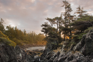
-A walk on the Wild Pacific Trail will weave itself into your soul, whether this is your first visit or a daily ritual.
-This easy, family-friendly trail traces the edge of reefs where shipwrecks, whales and vistas abound. You will be enthralled by Vancouver Island’s dramatic beauty and helpful interpretive signs will enrich your visit to Ucluelet’s famous 9km trail network. A perfect destination for photographers, storm watchers, bird watchers and hikers of all abilities. Wheelchair access is available at the lighthouse area.
-The trail can be walked in two main sections. Section one is a loop starting near the lighthouse (overlooking the Broken Group Islands of Pacific Rim National Park). Section two extends 5 km north from Big Beach Park. Then you can leave the wind-sculpted coastline to visit the largest trees in the area at Ancient Cedars grove. Breathe in the heady scent of a stand of trees over 800 years old!
-Lighthouse Loop ( 2.6 km loop) plus Terrace Beach Interpretive Trail (.5 km one way)
-Big Beach to Rocky Bluffs (5 km one way) plus Ancient Cedars Trail (1 km loop)
-Many visitors travel great distances to experience this spiritual retreat. It is no wonder that a multitude of languages can be heard as you stroll past frequent benches tucked into frequent viewpoints.
-The entire trail enjoys a dense rainforest canopy providing a natural umbrella in any weather, so any time of year is a rewarding time to visit. Click here for a MAP to the trail.
-To enrich your visit you can join a naturalist at 10:00 am daily next summer. Click this printable calendar for a sample calendar to plan your 2018 visit.
-Walks are FREE, please donate to help keep these events available.
-Email: info@wildpacifictrail.com
-Social Media
•Twitter/Facebook/Instragam @wildpacifictrail
-Address: Ucluelet, BC
-Website: https://tourismtofino.com/plan-your-trip/business-directory/wild-pacific-trail/
3.Amphitrite Point Lighthouse
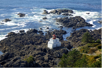
-Amphitrite Point Lighthouse is an active lighthouse near Uclulelet on the west coast of Vancouver Island in British Columbia, Canada, named after Amphitrite, the sea goddess and wife of Poseidon in Greek mythology.
-Amphitrite Point has the only active lighthouse in the Tofino-Ucluelet area accessible by automobile, with the only other local lighthouse being on Lennard Island, viewable only by air or boat. The Amphitrite Point Light is located at the southern end of the Ucluelet Peninsula and the north side of the Barkley Sound, approximately 3 kilometers south of downtown Ucluelet and 40 kilometers south of Tofino, British Columbia. The lighthouse tower is closed to the public but the grounds are open as part of the Lighthouse Loop section of the Wild Pacific Trail. In addition to hiking the trail to view the lighthouse, visitors can park at the end of Coast Guard Road and walk directly to the lighthouse in 2–3 minutes. Amphitrite Point, much like the rest of the Ucluelet Peninsula, is subjected to frequent winter storms and has an oceanic climate (Köppen Cfb) with approximately 3.3 metres (130 inches) of annual rainfall. The next active lighthouse to the north of Amphitrite Point Light is the Lennard Island Lighthouse off of Chesterman Beach; the next active lighthouse to the south is the Cape Beale Lightstation on the south side of Barkley Sound.
-Address: Coast Guard Drive, Ucluelet, British Columbia V0R 3A0 Canada
-Website: https://lighthousefriends.com/light.asp?ID=1104
-TEL: +1 604-217-3611
VI.History
-Archaeological evidence indicated the presence of First Nations along the outer west coast of Vancouver Island for at least 4,300 years. British Columbia’s recorded history began with European explorers searching for the Northwest Passage.
-Juan Pérez anchored and traded in 1774 on the west coast of Vancouver Island, at Nootka Sound, 100 km (62 mi) north of Ucluelet. In 177,5 Juan Francisco de la Bodega y Quadra sailed along the coast of Vancouver Island, heading north for Alaska. He did not stop, but roughly charted the coast in the vicinity of Kyuquot Sound. Captain James Cook of the British Navy anchored in Nootka Sound and went ashore in 1778. Maritime fur traders followed, such as Charles William Barkley, captain of the Imperial Eagle, who in 1787 arrived near Ucluelet harbour in Barkley Sound in search of sea otter pelts.
-In 1870, fur sealers came to the area seeking ports for vessels working the Bering Sea sealing grounds. Captain Francis, the owner of several sealing schooners, established a trading post in Ucluelet harbour. Ucluelet began to grow along with the sealing industry and became a bustling town. In the 1890s, more settlers began arriving on the news of pending road access from Port Alberni. Fishing was excellent and gold was to be found on Florencia Bay. Gold was found, but it was so fine and in such little quantity that it could not be worked profitably.
-The Presbyterian Church built a Mission House and school and a doctor was dispatched to the area in 1898. By 1900, more settlers had moved to the west coast of Vancouver Island. Development began bringing more infrastructure and services. The Canadian Pacific Railway operated a small freight boat sailing from Victoria three times a month. In 1903, a whaling station was established in Barkley Sound. In Ucluelet, the Amphitrite Point Light lighthouse, a government telegraph office, and a lifeboat station were built. As the First World War began, the fishing industry had started.
-When World War II began, the Government of Canada took measures to protect Vancouver Island’s west coast from potential invasions. The military established a seaplane base in Ucluelet and a land base at Long Beach. The road to Tofino, which had been worked on for thirty years, was finally completed.
-In 1941, the Direction Finding capabilities at RCAF station Ucluelet (Long Beach) were placed at the disposal of the Royal Canadian Navy. In 1942, RCN operators at Ucluelet, Coal Harbour and Alliford Bay were transferred to Gordon Head in Victoria.
-Ucluelet continued to prosper after the war luring more residents hoping for prosperity to the region. In August 1959, the long-awaited road to Port Alberni was finally opened.
-On February 26, 1952, Ucluelet became incorporated. Its status was changed to a District in 1997 to reflect, in part, the increasing population and increasing importance within the region.
VII.Other information
-Festivals
•Every March, the Pacific Rim Whale Festival is a week of events hosted by Ucluelet, Tofino and the Pacific Rim National Park Reserve. With a strong focus on marine life protection education, the event celebrates the annual return of migrating Pacific Grey Whales from their breeding and calving grounds along the Baja Peninsula of Mexico. Community events within the festival include gala dinners, children’s activities, workshops and live entertainment.
•Every odd year, Ucluelet hosts a leg of the Van Isle 360. It is a point-to-point race circumnavigating Vancouver Island, sailed in 10 legs. While the participants are in Ucluelet, the community hosts a special salmon barbecue with live music and a send-off event.
•In mid-June, there is the Annual Edge to Edge Marathon. Every year participants from within the community and beyond race from Tofino through the Pacific Rim National Park Reserve to Ucluelet.
•The Pacific Rim Summer Festival is held in early July with two weeks of music, word and multi-cultural concerts featuring national and international performers. Nightly concerts are performed at venues in Ucluelet, Tofino and the Pacific Rim National Park Reserve.
•The end of July or the last weekend are Ukee Days, a local celebration with several events such as a salmon barbecue on Friday, pancake breakfast and town parade on Saturday and a Ukee Days dance.
•Also throughout the Full moon weekend of July, the Soundwave music festival happens at the mussel beach campground. It showcases world class DJs, local artists, and live music, and usually 4,000-5,000 people are in attendance.
VIII.Contact information
-Government
•Governing body: Ucluelet Council
•Mayor: Mayco J. Noel
-Contact Email: mnoel@ucluelet.ca
•Councillors:
-Rachelle R. Cole
-Jennifer A. Hoar
-Lara K. Kemps
-Email: info@ucluelet.ca
Your email will be reviewed within one business day.
-Telephone (General Enquiries)
•Phone: 250-726-7744
-Fax
•Number: 250-726-7335
-Address
•200 Main Street, Ucluelet, BC, V0R 3A0
-Mailing Address
PO BOX 999
Ucluelet, BC
V0R 3A0
-For after hours emergencies (4:30pm to 8:00am) please call 250-726-8587
-Website: https://ucluelet.ca/community/district-of-ucluelet-office
