Algonquin, Illinois 作者: 来源: 发布时间:2021-11-03
I.Population and Area
₋Area
Land: 12.50 sq mi (32.39 km2)
₋Population
Total: 30,046
Density: 2,511.54/sq mi (969.73/km2)
II.Natural Geography
City Top View
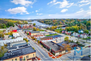
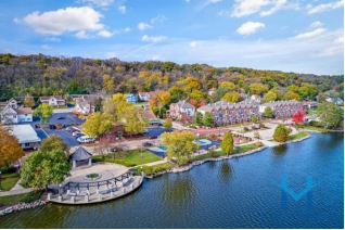
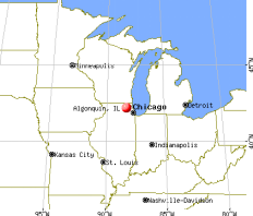
₋Algonquin is a village in McHenry and Kane counties, Illinois, in the United States. It is a suburb of Chicago, located approximately 40 miles (64 km) northwest of the Loop. As of the 2010 census the village's population was 30,046, and as of 2019 the estimated population was 30,897.
₋The village is known as "The Gem of the Fox River Valley", referring to the location of its downtown. Established in 1890 and long known as a sma ll river community, the village is making the transition into a major regional hub, as it has experienced considerable suburban growth over the past 20 years. Now stretching all the way west to the busy Randall Road corridor, Algonquin has become a major commercial center, with popular shopping centers and restaurants, as well as a growing corporate campus. Additionally, the village continues to see considerable residential growth. With this growth, the village has had to deal with challenges including traffic congestion and overburdened schools, yet has managed to increase the commercial tax base, preserve its character and history, and substantially increase its recreational offerings and quality of life.
III.ECONOMY
₋The average salary in Algonquin, IL is $16.33. Trends in wages increased by 0.6 percent in Q1 2020. The cost of living in Algonquin, IL is 32 percent higher than the national average. The most popular occupations in Algonquin, IL are Customer Service Representative (CSR), Administrative Assistant, and Dental Assistant which pay between $10.07 and $33.40 per year. The most popular employers in Algonquin, IL are Advocate Medical Group, Animal Care Clinic, and Community Unit School District 300.
₋Website: https://www.payscale.com/research/US/Location=Algonquin-IL/Salary
IV.Industrial Characteristics
₋A growing number of businesses can be found in Algonquin. From a manufacturing corridor along Algonquin Road between Pyott Road and Route 31 to a planned corporate campus on the west side of Randall Road, industry is a significant part of the Algonquin area economy.
₋Algonquin Industrial Park
₋Just west of the village's Old Town District is the Algonquin Industrial Park, located along Algonquin Road. Several major companies can be found in this area, including tool, die, and mold industries, plastics industries, and transportation-related businesses. Major businesses located in this area include Wauconda Tool & Engineering, Kenmode Tool & Engineering, Schiffmayer Plastics, Crystal Die & Mold, VCP Printing, Burnex Corporation, and Lion Tool. Algonquin's main Post Office is also located in this area. The post office also serves nearby Lake in the Hills, even though the two municipalities have separate zip codes.
₋Algonquin Corporate Campus
₋Under development is the Algonquin Corporate Campus on the village's west side along Randall Road. Set on over 1,000 acres (4.0 km2) stretching from Randall Road west to Square Barn Road, and north of Huntley Road, the development is aimed at providing more jobs to the greater Algonquin area. As a result, any potential business or building in the park that brings high-paying jobs has the opportunity for incentives and to have the development review process expedited. Located in the park is Young Innovations, a company that specializes in oral healthcare supplies; and Advantage Moving and Storage, a moving and storage company. Two multi-tenant industrial/office buildings have also been constructed, Rothbart Building #1 and the Algonquin Corporate Condominiums, both of which already have tenants, including Progressive Solutions and DirecTV. Additional buildings are planned for construction. Businesses the village is targeting for the park include those specializing in healthcare, technology, and research and development. Located directly adjacent to the Algonquin Corporate Campus are the village's outdoor malls Algonquin Commons and Algonquin Galleria. Also part of the park is the mixed-use Esplanade development, which currently includes 2nd and 3rd story office space for several companies.
₋Other industries
₋Other major industries in Algonquin include Duro-Life, a manufacturer of machine parts located along Randall Road, and Meyer Material Service, a mining company located along Route 31.
₋There is also over 250,000 sq ft (23,000 m2). of small office and medical office space located in various buildings throughout town, most heavily concentrated along Randall Road, Algonquin Road, and Illinois Route 31. The largest such series of office buildings is the Briarwood Center at the intersection of Randall Road and County Line Road.
V.Attractions
1.Three Oaks Recreation Area
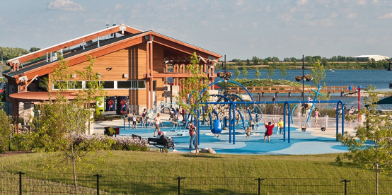
₋The City of Crystal Lake reclaimed the long-abandoned Vulcan Lakes quarry and turned it into an amazing recreation experience. Enjoy pristine waters, natural habitat, and incredible fishing. Rent rowboats, canoes, kayaks, sailboats, and paddle boats. Plan a picnic, and overlook breathtaking views of the water and lake islands. Make memories at the kid-friendly spray park, and eat a lakeside lunch at our outdoor dining patio. Experience recreational scuba diving, or become certified through various community scuba schools in our Scuba Zone.
₋Entrances and Parking
₋Crystal Lake residents, with a valid City vehicle sticker attached to their windshield, receive free parking into Three Oaks Recreation Area. All vehicles that enter the park without a valid City vehicle sticker will be charged $5.00 per vehicle.
₋Vehicles may enter from the West or North entrance. From the West, enter the park through the Main Street entrance, which is located by Mayfair Furniture and Carpet. To enter the park from the North, come in through the Highway Route 14 entrance, which is between Harris Bank and Cooper Tire. Pedestrian pathways are available on the East, West, and North access points.
₋Address: 5517 Northwest Hwy, Crystal Lake, IL 60014, United States
₋Phone: +1 815-459-2020
₋Website: https://www.crystallake.org/three-oaks-recreation
2.Cornish Park
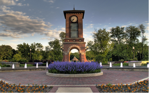
₋From the intersection of Algonquin Road and Main Street, simply go east on Algonquin Road until you hit Harrison. Take a right onto South Harrison Street and the park will be on the left.
₋About This Location
₋Cornish Park is a 2.43-acre park located next to the Fox River. It's home to Algonquin's signature Cornish Park clock tower. It also houses many historical markers and a few buildings that tell the history of Algonquin. Even its name is historical--Dr. Andrew Cornish was one of Algonquin's earliest settlers. The park has many attractive features: a playground, walking path, fishing spots, beautiful view of the river, and a gazebo available for rental by completing the application online. The park is located just east of Main Street, so there are always good stores to hit on your way to, or from, the park!
₋Address: 101 S Harrison St, Algonquin, IL 60102, United States
₋Phone: +1 847-658-2700
₋Website: https://www.algonquin.org/egov/apps/locations/facilities.egov?view=detail&id=4
3.Fox Bluff Conservation Area
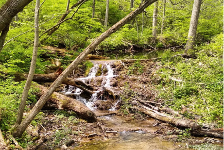
₋The Fox Bluff complex includes woodlands, wetlands, fens, wet prairies and 3,530 linear feet of shoreline along the Fox River. The topography is steep with varying slopes and ravines. The northern portion is currently open to the public for hiking and access to the Fox River.
₋The southern section is the former 116-acre Camp Algonquin. The entire 273 acres is currently undergoing a Master Plan process to provide future hiking, fishing and other public amenities.
₋Fox Bluff Conservation Area is an area rich with history. Some of the more known past peoples, families and features are: The five (5) Native American Tribes Chippewa, Fox, Potawatomi, Sauk, Winnegabo; Ashahel B. Hinsdale purchased 260 acres both east /west of Cary Algonquin Road; Solomon + Elizabeth Hamilton purchased east rocky hillside leading down to the Fox River; Lowe Farmstead; Morton and Jane Weinress Estate; John Plain Recreation Area; Fox Trails Ski, Swim and Tennis Sports Club; The Nevermore (Teen Nightclub); and Harry’s Hopes (Music/Adult Night Club).
₋The site is recognized as the place chosen by the first white settlers of McHenry County, the Gillilan family. At the time of the Gillilan arrival the family consisted of Samuel (husband), Margaret (wife) and their 8 children. The exact location of their first winter encampment and log home that followed is debated among historians, however, the consensus believes that the encampment and settlement was somewhere within sections 23, 26, or 27 of Algonquin Township. The Gillilan family crossed the Fox River and set-up camp along the west side on November 18, 1834, entering a wilderness only 2 years removed from the end of the Blackhawk Wars, yet still belonging to the Indians according to Federal law.
₋Tracing its roots back to the 1800s, Camp Algonquin emerged from the Progressive Era as a permanent camp to help treat ill and under privileged women, children, and babies of Chicago. Established on 20 acres located adjacent to the Fox River, the camp was supported by the Chicago Bureau of Charities, Chicago Board of Trade, Chicago Tribune, Oak Park churches, and numerous private donors.
₋In 1910, Jens Jensen, the well regarded landscape architect, was hired to produce a plan for the grounds of Camp Algonquin. During a visit to the camp Jensen shared a story as to why so many of the forest trees were bent over towards the river and not in the direction of the prevailing winds. Jensen goes on to say that this is a frequent feature of trees found in the vicinity of Indian camping grounds and comes from the fact that when the trees were saplings they were used by Indian mothers for the swinging of their papooses. A detailed site plan from Jensen dated February 1911 depicts 16 buildings, swimming pool, council ring, vegetable gardens, native landscaping, pedestrian paths / trails, carriage roads, benches and bridges. The Jensen plan is the earliest known drafted map of Camp Algonquin.
₋Over the next half century the camp continued to expand with the addition of numerous cottage and support buildings along with programmed services and activities. In the 1980s the camp received significant additions to both building needs and land holdings. Improvements included, a new dining hall, camp office, Activities Center, winterization of several buildings, and the addition of 60 acres north of the existing property holdings. Camp Algonquin exposed children and adults, in many instances for the very first time or at least while only at camp, to activities such as swimming, canoeing, campfires, sing-alongs, and elementary tasks such as chores and scheduling. The most recent focus of Camp Algonquin was, “to enable students to experience transformative education by living and learning together in closeness with the natural environment.” Available curriculums included: environmental studies, team building, and crafts.
₋In the 1960s a group of businessmen converted the original farmstead and surrounding property into a ski resort equipped with ski runs, tow ropes, lights, and snow making machines. A Swiss-style chalet was built next to a barn within the farmstead. The chalet contained a ski shop, ski school headquarters, restaurant, and cocktail lounge. The remodeled barn contained a ski rental and repair shop, ski patrol headquarters, changing rooms, and nursery. The ski resort continued to operate until the mid 1970s when it was eventually closed and remodeled into a cozy music venue called Harry Hope’s. Performers of the venue included: Muddy Waters, Steve Goodman, and Mary Travers. The club operated until 1981 when it was eventually moved to Elgin. Prior to the closing of the ski resort, the property continued to expand its recreational opportunities with the establishment of the Fox Trails Country Club. The Club underwent numerous name changes over the years, but basically the programming and activities remained similar.
₋Address: 1300 Cold Springs Rd, Algonquin, IL 60102, United States
₋Phone: +1 815-338-6223
₋Website: https://www.mccdistrict.org/visit___explore/places_to_go/find_a_site/fox_bluff.php
VI.History
₋Long before Europeans settled in Algonquin, the Potawatomi Native Americans originally inhabited the land. Algonquin was the location of Indian burial mounds known in the 1800s as the Algonquin Mounds. By 1834 the first settler of Algonquin, Samuel Gillilan, came to the area from Virginia. Settlers Dr. Cornish, Dr. Plumleigh, Eli Henderson, Alex Dawson, and William Jackson arrived shortly thereafter. There was some dispute regarding the original name of Algonquin, and numerous other names were suggested including Denny's Ferry, Cornish Ferry, Cornishville, and Osceola. But Samuel Edwards suggested the name Algonquin and on December 23, 1847, the name Algonquin became official.
₋The first signs of economic growth occurred in 1855 when the town saw the construction of the railroad, which enabled farmers in the neighboring area to have other means of getting their products to the markets in Chicago. Finally on February 25, 1890, the Village of Algonquin was formed.
₋The Village Hall of Algonquin was erected on January 31, 1907, at 2 South Main Street, and is still standing today, where it functions as a historical landmark and community gathering place. It served as the village hall of Algonquin until a new village hall was built at 2200 Harnish Drive in 1996.
₋From 1906 to 1913, the automobile companies began to go to the Algonquin Hill Climbs, which was an event where if an automobile was able to make it up a series of steep hills in the village, it would be given the stamp of approval. And because of that, the Algonquin Cup was formed which received national recognition at the time. The two hills used in the race were the Phillips Hill which extends from Illinois Route 31 to the cemetery and Perry Hill, located south of downtown, and which is now Lundstrom Lane. The village created a new hill for the race called Huntington Hill, which is now Huntington Drive. A park stands in place of the finish line of Huntington Hill at the intersection of Huntington Drive and Circle Drive which is called Hill Climb Park. The festival in recognition of the event continues to be held each year.
₋Algonquin road route 62 now, was once noted as the first bridge to be installed on an incline. The first bridge was level with a steep incline headed east. It was later replaced with a 4 lane bridge with an incline to reduce stress on vehicles headed east.
₋For much of the 20th century, Algonquin was a quasi-resort town and people from the Chicago area would visit the town in order to escape urban life. The Fox River offered immense recreational opportunities and several summer homes were constructed. Soon, more people began living in Algonquin year-round. Algonquin remained a small town for much of the 20th Century, growing steadily, until the 1980s, when the village's population exploded with new residential construction. The development continued in earnest in the 1990s and 2000s. The village's first shopping center, Algonquin Town Center, was constructed in the late 1980s on East Algonquin Road and numerous die & mold industries were established west of downtown. In the 1990s, development shifted to Randall Road, which saw the construction of numerous retailers, restaurants, and services, beginning in 1993. In 2004, the 80-store Algonquin Commons outdoor mall (the largest outdoor mall in Illinois) opened for business, followed by the Algonquin Galleria outdoor mall, which is under development and saw its first stores open in 2006. In the mid-2000s, development also began on the Algonquin Corporate Campus, which is slated to include industrial and office development spread over 1,000 acres (4.0 km2) on the southwest side of the village, bringing hundreds of high-paying jobs to the area.
VII.Other Information
₋Transportation
₋Algonquin is a center of transportation for McHenry and Kane Counties. Some of the major roadways include:
₋Randall Road is a major multi-lane highway serving the village's western side. The road is entirely lined with major outdoor shopping malls, big-box retailers, restaurants, and a major corporate center which serve the region. For a mile-long stretch between Harnish Drive and Corporate Parkway, near the village's malls, the road is six lanes wide with a landscaped center median with dual left turn lanes. Elsewhere, the road is four lanes wide with a striped median with single left turn lanes. The road connects Algonquin with Crystal Lake and Lake in the Hills on the north and Carpentersville, Elgin, South Elgin, Geneva, and the rest of the Fox River Valley suburbs to the south.
₋Illinois Route 25 is a north-south road on the village's eastern side which ends at Illinois Route 62. It connects the village to Carpentersville, East Dundee, Elgin, and the rest of the Fox River Valley suburbs to its south.
₋Illinois Route 31 (Main Street) is a major north-south road going through the heart of the village's downtown. Despite Route 31's high traffic volume, the road is only two lanes wide with a center striped median and left turn lanes, resulting in considerable backups at the road's intersection with Algonquin Road. In the Old Town District, there are on-street parallel parking spots to service the downtown shops located along the road. Because the shops and many other buildings are so close to the road, widening is not an option to ease traffic congestion, so a western 31 bypass of the village's downtown is planned. This bypass would include an interchange at Algonquin Road, currently one of the most congested intersections in McHenry County. Illinois Route 31 connects to Crystal Lake and McHenry on the north and Carpentersville, West Dundee, Elgin, and St. Charles on the south.
₋Illinois Route 62 (Algonquin Road) is a major east-west arterial road. West of Illinois Route 31, the road loses the Illinois Route 62 designation and becomes a county highway (Algonquin Road) that continues west to Illinois Route 47. The road is locally infamous for its westbound backups from Sandbloom Road west to Illinois Route 31, particularly during the weekday evening rush hour. Algonquin Road is four lanes with a center median for its entirety in the village. West of Randall Road, the median is landscaped, while east of Randall, it is striped. Algonquin Road connects the village to Huntley on the west and other major northwest suburbs like Hoffman Estates, Schaumburg, Arlington Heights, Mount Prospect, and Des Plaines on the east. West of Pyott Road, Algonquin Road roughly forms the border between Algonquin and Lake in the Hills.
₋Lake Cook Road terminates at East Algonquin Road on the eastern edge of the village and connects it to Barrington, Palatine, Arlington Heights, Buffalo Grove, Wheeling, Northbrook and Glencoe.
₋Pyott Road and Lakewood Road terminate at West Algonquin Road, just north of the village limits, and connect the village to Lake in the Hills, Crystal Lake, and Lakewood.
₋Other important roads within Algonquin include Highland Avenue, River Road, Haegers Bend Road, Sandbloom Road, Souwanas Trail, Edgewood Drive, Hanson Road, County Line Road, Sleepy Hollow Road, Longmeadow Parkway, Huntington Drive, Harnish Drive, Square Barn Road, Stonegate Road, Bunker Hill Drive, Boyer Road, and Corporate Parkway.
VIII.Contact Information
Government
Type: Council–manager
President: John Schmitt
City Hall
Address: 2200 Harnish Drive
Algonquin, IL 60102-5995
TEL: 847-658-2700
Website: https://www.algonquin.org/egov/docs/1247845022156.htm
