Cedar Rapids, Iowa 作者: 来源: 发布时间:2021-11-04
I.Population and Area
₋Area
Land: 71.85 sq mi (186.09 km2)
₋Population
Total: 126,326
Density: 1,858.90/sq mi (717.73/km2)
II.Natural Geography
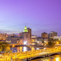
Night View
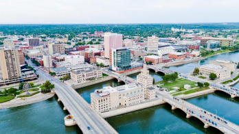
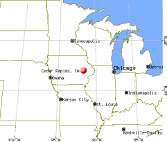
₋Cedar Rapids is the second-largest city in Iowa and is the county seat of Linn County. The city lies on both banks of the Cedar River, 20 miles (32 km) north of Iowa City and 100 miles (160 km) northeast of Des Moines, the state's capital and largest city. It is a part of the Cedar Rapids/Iowa City Corridor of Linn, Benton, Cedar, Iowa, Jones, Johnson, and Washington counties.
₋As of the 2010 United States Census, the city population was 126,326. The estimated population of the three-county Metropolitan Statistical Area, which includes the nearby cities of Marion and Hiawatha, was 255,452 in 2008. Cedar Rapids is an economic hub of the state, located at the core of the Interstate 380 corridor.
₋The Cedar Rapids Metropolitan Statistical Area (MSA) is also a part of a Combined Statistical Area (CSA) with the Iowa City MSA. This CSA plus two additional counties are known as the Iowa City-Cedar Rapids (ICR) Corridor and collectively have a population of nearly 500,000.
₋A flourishing center for arts and culture in Eastern Iowa, the city is home to the Cedar Rapids Museum of Art, the National Czech & Slovak Museum & Library, the Paramount Theatre, Orchestra Iowa, Theatre Cedar Rapids, the African American Museum of Iowa, and the Iowa Cultural Corridor Alliance. In the 1990s and 2000s, several Cedar Rapidians became well-known actors, including Bobby Driscoll, Ashton Kutcher, Elijah Wood, and Ron Livingston. The city is the setting for the musical The Pajama Game and the comedy film Cedar Rapids.
₋Cedar Rapids is nicknamed the "City of Five Seasons", for the so-called "fifth season," which is time to enjoy the other four. The symbol of the five seasons is the Tree of Five Seasons sculpture in downtown along the north river bank. The name "Five Seasons" and representations of the sculpture appear throughout the city in many forms.
III.ECONOMY
₋The average salary in Cedar Rapids, IA is $65k. Trends in wages decreased by -0.6 percent in Q1 2020. The cost of living in Cedar Rapids, IA is 3 percent higher than the national average. The most popular occupations in Cedar Rapids, IA are Software Engineer, Electrical Engineer, and Senior Systems Engineer which pay between $39k and $110k per year. The most popular employers in Cedar Rapids, IA are Rockwell Collins, Inc., Transamerica, and United Fire Group.
₋Website: https://www.payscale.com/research/US/Location=Cedar-Rapids-IA/Salary
IV.Industrial Characteristics
₋Cedar Rapids is one of the largest cities in the world for corn processing. The grain processing industry is Cedar Rapids' most important sector, directly providing 4,000 jobs that pay on average $85,000, and also providing 8,000 indirectly. Fortune 500 company Collins Aerospace and trucking company CRST are based in Cedar Rapids, and Aegon has its United States headquarters there. A large Quaker Oats mill, one of the four that merged in 1901 to form Quaker Oats, dominates the north side of downtown. Other large companies that have facilities in Cedar Rapids include Archer Daniels Midland, Cargill, General Mills, Toyota Financial Services and Nordstrom. Newspaperarchive, based in Cedar Rapids, is the largest newspaper archive in North America with a repository of more than 150 million pages assembled over 250 years; it was taken offline for two days by the 2008 flood.
V.Attractions
1.Cedar Rapids Museum of Art
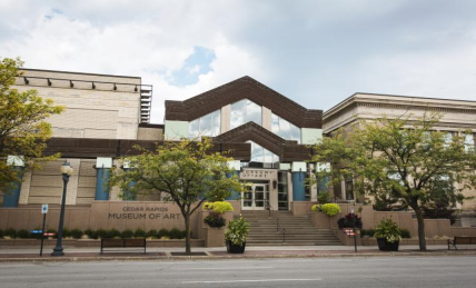
₋The Cedar Rapids Museum of Art is a museum in downtown Cedar Rapids, Iowa, United States. The museum is privately owned and was established in 1905. The museum acquired the old Cedar Rapids Public Library building after the library moved into a new location in 1985. The current home of the museum, designed by post-modern architect Charles Moore, was built adjoining the old library in 1989.
₋The mission of the Cedar Rapids Museum of Art is to excite, engage, and educate its community and visitors through its collection, exhibitions and programs.
₋The museum has significant collections from several prominent Iowa artists. The 63,000-square-foot (5,900 m2) museum displays temporary exhibitions of contemporary art and hold the world's largest collection of works by Grant Wood, Marvin Cone, and Bertha Jaques, works by Mauricio Lasansky and the Riley Collection of ancient Roman portrait busts. The Grant Wood collection includes his paintings “Woman with Plants” and “Young Corn.” In 2002, the CRMA was given the building that houses the original studio of Grant Wood. Located just three blocks from the Museum, the loft studio, known by its fictitious address of 5 Turner Alley, was designed and constructed by Wood, who lived and worked there between 1924 and 1935. It was here that he painted American Gothic (1930)—now part of the collection of the Art Institute of Chicago—and many of his most famous paintings. The Grant Wood Studio is open to the public for guided tours Saturdays and Sundays.
₋The Marvin Cone collection includes many of his best-known landscapes and abstracts. Cone was a collaborator and friend of Grant Wood.
₋The museum also includes significant pieces by Mauricio Lasansky, Ann Royer, and many others.
₋Address: 410 3rd Ave SE, Cedar Rapids, IA 52401, United States
₋Opened: 1905
₋Website: http://www.crma.org/
2.Brucemore
₋Brucemore, a park-like, 26-acre (110,000 m2) estate in the heart of Cedar Rapids, Iowa, is the site of a Queen Anne-style mansion, formal gardens, a children's garden, night garden, pond, orchard, and woodland. Built between 1884 and 1886 by Caroline Sinclair, widow of pioneer industrialist T.M. Sinclair, Brucemore has been home to three prominent families who used the estate as a center for culture and the arts. Brucemore, whose name alludes to the Scottish moors of the second owner's ancestral home, is Iowa's only National Trust Historic Site and is preserved by the National Trust for Historic Preservation in co-stewardship with Brucemore, Inc. Under the name of the T.M. Sinclair Mansion, it is listed on the National Register of Historic Places. The mansion has three stories, and contains twenty-one rooms. Notable features of the home are its steeply gabled roof, five chimneys, and several turrets.
₋Brucemore is the story of three wealthy families: industrialists, entrepreneurs, philanthropists, boosters, neighbors, and friends. The men created great fortunes: Thomas Sinclair in meatpacking; George Bruce Douglas in starch processing; and Howard Hall in manufacturing. However, the women of Brucemore are at the heart of the story; Caroline Sinclair built the mansion; Irene Douglas transformed it to a country estate; and Margaret Hall gave it to the National Trust.
₋The Sinclairs (1886–1906)
₋In 1871, Thomas McElderry and Caroline Soutter Sinclair moved to Cedar Rapids from New York City. Thomas started a meatpacking business, the T.M. Sinclair & Co., which became the city's largest business. Sinclair died in an 1881 accident at the plant, leaving Caroline to bring up their six children, the youngest aged just six months. In 1884, Caroline Sinclair purchased land that was then beyond the city limits and started to build a Queen Anne-style mansion she named "Fairhome."
₋The home was designed by Maximillian Allardt, an Indianapolis architect. When his daughter fell ill, Allardt left the job, and Henry Josselyn and Eugene Taylor continued where he left off. The original plan for the house included a great hall, eight bathrooms, nine bedrooms, fourteen fireplaces, and a grand staircase. Sinclair added a conservatory to the south side of the house.
₋Completed in 1886 for $55,000, the home was described as "the grandest house west of Chicago" to the local paper.
₋In 1906, when all her children had grown, Caroline traded homes with George Bruce Douglas, and moved to 800 Second Ave SE.
₋The Douglases (1906–1937)
₋George Bruce Douglas was a partner in his father's business, the Quaker Oats Company. George moved into the home with his wife Irene, and daughters Margaret and Ellen and renamed it Brucemore. Under George's direction, the size of the property was increased to 33 acres (130,000 m2), and several buildings were constructed, including a guesthouse, greenhouse, carriage house, squash court, and servants' quarters. He also moved the entrance to the south side. The interior was also upgraded, with exposed ceiling beams and butternut paneling added to the great hall. This expansion cost over $30,000 and was designed by Howard Van Doren Shaw, a Chicago architect known for his North Shore mansions. In the 1920s, a mural was added that showed the story of "The Ring of the Nibelung" from Richard Wagner. A 714-pipe organ from the Skinner company was added to the third floor. In 1925, Grant Wood designed a sleeping porch which was added to the house. In 1927, a swimming pool was added.
₋In 1923, George died. Fourteen years later, Irene followed him and willed the home to their oldest daughter Margaret.
₋The Halls (1937–1981)
₋Margaret Douglas married Howard Hall in 1924. The couple lived on the Brucemore grounds, residing in the Garden House from the start of their marriage until the death of Margaret's mother. While they lived there, they sold off some of the property, reducing the estate to its current 26 acres (110,000 m2). They also enclosed the western porch, and added picture windows to the master bedroom, the library, and the dining room. In two of their more unusual enhancements to the house, the Halls added two basement recreation rooms, "The Tahitian Room", and a "Grizzly Bar". The Tahitian room is designed to resemble a tropical island, including a faux hut roof, and a switch that can create artificial rain. The Grizzly room is decorated like a Wild West or Alaskan saloon.
₋The Halls kept several pets on the property, including two German shepherds, a monkey and several birds. But their most famous pets were three lions, all named Leo. Jackie, the lion that roars at the beginning of MGM movies, is related to one of the Leos. One of the lions as well as 20 dogs are buried in the pet cemetery near the gardens.
₋All of Brucemore's residents used their wealth and standing to promote the community that had supported them. When Margaret died in 1981, she bequeathed Brucemore to the National Trust for Historic Preservation.
₋Community cultural center
₋Today, Brucemore is a hub of cultural,philanthropic, and educational activities, welcoming 40,000 people each year to a variety of events, including festivals, concerts, tours, garden programs, children and family activities, outdoor theatre, and more.
₋Address: 2160 Linden Dr SE, Cedar Rapids, IA 52403, United States
₋Phone: +1 319-362-7375
₋Website: https://www.brucemore.org/
3.African American Museum of Iowa
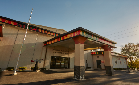
₋The African American Museum of Iowa (AAMI), nestled along the Cedar River near downtown Cedar Rapids, Iowa, United States, has been carrying out its mission “To preserve, publicize, and educate the public on the African American heritage and culture of Iowa” since its incorporation as a 501(c)(3) organization in 1994. It has become the leading educational resource on African American history in Iowa and has two on-site exhibits: a permanent exhibit called Endless Possibilities, and the 2017 temporary exhibit – If Objects Could Talk. Additionally, the AAMI has several "traveling exhibits" that are available free of charge for use by schools, libraries, businesses, etc.
₋In 2011, the AAMI served over 52,000 people, offering tours, educational programming for all ages, special events, a summer camp, and much more across the state of Iowa.
₋The African American Museum was started in 1994 by a small group from the Mount Zion Missionary Baptist Church in Cedar Rapids, with the goal of preserving the heritage of African Americans in Iowa in celebration of Black History Month. That year, the African American Heritage Foundation, Inc. was chartered in Iowa as a 501 non-profit organization.
₋Four years later, in 1998, the Foundation hired its first full-time employee, Joseph McGill, who served as the Executive Director. In 2000, a temporary museum opened in Westdale Mall in Cedar Rapids, and in April 2002, construction began on a new 17,000 square foot, state-of-the-art facility along the Cedar River.
₋In May 2003, Thomas Moore was named interim Executive Director for the AAMI; the interim was dropped in November. The Grand Opening of the AAMI was on September 19, 2003 and highlighted the Exhibition|permanent exhibit Doorways: A History of African Americans in Iowa.
₋The following year brought the creation of an endowment fund for the museum, as well as the opening of the new Africa section of the permanent exhibit. Visitors started in West Africa, where they passed through the “Door of No Return” and entered a slave ship to experience the famous Middle Passage from Africa to the United States.
₋In 2005, the 12th Ave. bridge near the AAMI was renamed the Dr. Martin Luther King Jr. Memorial Bridge, and a public art piece, Trumpet, was unveiled on the museum grounds near the Cedar River Trail.
₋Museum chapters were established in eight communities across Iowa in 2006, and in 2007 the AAMI received a grant from the Institute of Museum and Library Services (IMLS) to hire and train two staff members to coordinate the chapter program. Later that same year, the AAMI received a second grant from the IMLS to conduct a statewide oral history project entitled Adult Voices–Children’s Eyes: Iowa's African American Oral History Project. This innovative and ongoing project trained youth groups across Iowa to conduct oral histories in their communities. These sessions recorded important events and sparked a passion for history among African American youth.
₋The following year, the AAMI was devastated by the Iowa flood of 2008. The first floor of the Museum, home to the education and collection staff as well as the gift shop, rental hall, and both exhibits, was filled with 5.5 feet of standing water. This catastrophic natural disaster caused significant damage to the building and at least half of the Museum's artifacts, necessitating $1.3 million in repairs.
₋On January 17, 2009, the AAMI was reopened to the public, featuring building renovations and repairs as well as a new temporary exhibit: No Roads Lead to Buxton. A new permanent exhibit, Endless Possibilities, was opened on December 15, 2009 and uses Photograph|photos, objects, stories, and multimedia to trace the journeys of Iowa’s African Americans.
₋Located in: Czech Village / New Bohemia Main Street District
₋Address: 55 12th Ave SE, Cedar Rapids, IA 52401, United States
₋Phone: +1 319-862-2101
₋Website: https://blackiowa.org/
VI.History
₋Early history
₋The location of present-day Cedar Rapids was in the territory of the Fox and Sac tribes.
₋The first white settler on the site of the future city was Osgood Shepherd, who built a log cabin (which he called a tavern) in 1837 or 1838 next to the Cedar River (then known as the Red Cedar) at what is now the corner of First Avenue and First Street Northeast. Shepherd was a squatter who claimed the land without legal title and also a reputed ne’er-do-well, who, if he was not a horse thief himself, definitely consorted with them. Early on, it appears that he “jumped the claim” of another squatter, Wilbert Stone, who had built a cabin and platted out a town, some distance south of Shepherd's cabin, that he called Columbus. Shepherd drove Stone across the river, claiming that Stone had built his cabin on Shepherd's land, then sold Stone's cabin to a buyer named Hull. Shepherd later tried the same tactic with perhaps the first settler on the west side of the river, Robert Ellis, but Ellis happened to be chopping wood at the time and warned that someone would be dead if Shepherd did not retreat.
₋The true founders of the city were George Greene, Nicholas Brown, and a few others. Brown had experience as a miller and Greene had surveyed much of eastern Iowa, so both saw the value of the spot Shepherd had claimed. It was right next to the rapids—a prime spot to build a mill—the last set of rapids on the river before the Cedar fed into the Iowa River, meaning that goods milled on the spot could be carried by boat down river to the Mississippi. In 1841, they formed a partnership that bought out Shepherd's claim and platted out a town they called Rapids City. Brown immediately constructed a primitive dam and then built the town's first mill. His crude dam soon washed away, prompting Greene to induce Alexander Ely, an engineer from Michigan, to build a proper dam that would create a millrace capable of powering several mills.
₋At this time, the city was confined to the east side of the river. The west bank soon contained a village named Kingston for resident David King who early on operated a rope ferry across the river.
₋The town was formally incorporated by the Iowa State Legislature on January 15, 1849 as Cedar Rapids, named for the rapids in the Cedar River (the river itself was named for the large number of red cedar trees that grew along its banks). The population was less than 400.
₋During the 1850s Cedar Rapids grew in size, and it was during this decade that the Czech population became substantial; when the town was reincorporated in 1856, a quarter of its roughly 1600 inhabitants were Czech immigrants. The availability of cheap land in the new state of Iowa happened to coincide with the Revolutions of 1848 in the Austrian Empire that caused a large number of Czechs to flee their homeland and emigrate to the U.S. In 1851 was founded the institution that would eventually become Coe College. The decade also witnessed attempts by local leaders to improve the city's access to distant markets, first through purchase of a steamboat (aptly named Cedar Rapids) and ultimately through investment in a railroad. The first locomotive rolled into town on June 15, 1859.
₋Railroads were an important factor in the development of the state and the growth of cities along the rail lines. By the end of the 19th century, the 23rd largest state was the fifth largest in track mileage.
₋In this same decade, "Major" John May, an inventor and land speculator, purchased the island (now called "May's Island") situated between Cedar Rapids and Kingston with the intention of founding a town he called May Island. When that scheme proved impractical due to the island's tendency to flood, he conceived the idea of making his island the center of a larger city that spanned the river and convinced the state legislature to officially name the land he had bought there, just south of Kingston, "West Cedar Rapids."
₋Cedar Rapids annexed the community of Kingston in 1870 and constructed an iron bridge across the river along the line of the current Third Avenue bridge.
₋The economic growth of Cedar Rapids increased in 1871 upon the founding of the Sinclair meatpacking company. The plant allowed for year-round meatpacking because ice could be harvested from the Cedar River in winter to chill an icehouse, and within a few years it became one of the largest factories of its kind in the country, employing 400 people. In 1873 was built the oatmeal mill that would ultimately become the flagship operation of the Quaker Oats Company, and the largest cereal mill in the world.
₋In 1909 the city acquired May's Island for the purpose of making it the seat of government; then, as now, there were ill feelings between east- and west-siders in Cedar Rapids, and the city's leaders hoped that putting City Hall in the "neutral territory" of the island would help ease tensions. In 1919, the residents of Linn County voted to move the county seat from Marion to Cedar Rapids, partially because Cedar Rapids had offered to donate the southern third of the island as a site for a new county courthouse and jail.
₋In 2010, the Census Bureau reported Cedar Rapids' population as 87.98% white, and 5.58% black.
₋Flood of 2008
₋During the Iowa flood of 2008, the Cedar River reached a record high of 31.12 feet (9.49 m) on June 13 (the previous record was 20 feet (6.1 m)), surpassing the 500-year flood plain. 1,126 city blocks were flooded, or more than 10 square miles (26 km2), and 561 city blocks were severely damaged, on both banks of the Cedar River, comprising 14% of the city's total area. A total of 7,749 flooded properties had to be evacuated, including 5,900 homes and 310 city facilities, among them the City Hall, Central Fire Station, Main Public Library, Ground Transportation Center, Public Works building, and the Animal Control building. It is estimated that at least 1,300 properties had to be demolished in the Cedar Rapids area because of the flood, which caused several billions of dollars in damages. More than 4,000 members of the Iowa National Guard were activated to assist the city. The temporary levees became saturated not only with the flood waters but also with additional rainfall, causing them to fail.
₋Until the flood, the city's government was headquartered in the Veterans Memorial Building, near the Linn County Courthouse and jail on Mays Island in the Cedar River, making Cedar Rapids one of a few cities in the world, along with Paris, France, with governmental offices on a municipal island.
₋Flood of 2016
₋During the flood of 2016, remnants of Hurricane Paine from the eastern Pacific Ocean via the Gulf of California caused the second highest recorded crest of the Cedar River in Cedar Rapids, reaching 22 feet (6.7 m) on September 27. The inundation of southern Minnesota, central and western Wisconsin, and northeastern Iowa by Hurricane Paine's remnants began on September 21 and 22 and continued until the end of the month. The cresting in Cedar Rapids was below the initial estimate of 25 feet (7.6 m) and the revised estimate of 23 feet (7.0 m), but more than 10 feet (3.0 m) above the flood stage of 12 feet (3.7 m). The flood was above levels considered to have about a 1% chance of occurring in a given year. More than 5,000 homes were affected, causing over 5,000 people to evacuate. The Cedar Rapids Schools were closed for a week.
₋In 2015, Cedar Rapids approved a $625 million flood protection plan over 20 years for levee improvements. Although the improvement to the levee system in Cedar Rapids had not been completed due to over $80 million in funding not appropriated by the United States Congresses of 2014 and 2016 and the voting down by local residents of a temporary increase in the local sales tax to pay for the levee improvements, out of school students along with hundreds of thousands of volunteers and 412 Iowa National Guard troops filled more than a quarter of a million sandbags in a successful effort to prevent any major flooding of the city outside the evacuation zone. A 9.8-mile (15.8 km) system of Hesco barriers, earthen berms, and over 400,000 sandbags were used to plug the gaps in the levee system. The city of Cedar Rapids purchased additional Hesco barriers from Iowa City for $1.4 million. Numerous upstream cities that had been earlier affected by the September flooding and mandatory evacuations, including Charles City, Greene, Manchester, Clarksville, Shell Rock, Vinton, Janesville, Cedar Falls and Waterloo, sent hundreds of thousands of unused sandbags to support efforts in Cedar Rapids and nearby communities. The remnants of Hurricane Paine did not produce any rain to saturate the temporary earth berms and sandbags, which would have greatly increased the likelihood of breach in the temporary levee structures, causing a much greater flooded area; the river crested during very sunny weather. Additionally, beginning on September 25, 300 to 400 National Guard troops along with the Iowa State Patrol, other law enforcement agencies, and 60 duly sworn law enforcement officials enforced a nightly 8pm to 7am curfew.
VII.Other Information
₋Transportation
₋Cedar Rapids is served by Cedar Rapids Transit, consisting of an extensive bus system and taxis. Cedar Rapids Transit operates scheduled bus service throughout the city and to Marion and Hiawatha. A series of enclosed pedestrian skywalks connect several downtown buildings.
₋The city is also served by The Eastern Iowa Airport (formerly known as the Cedar Rapids Airport), a regional airport that connects with other regional and international airports. Cedar Rapids Transit and private bus lines also connect at the airport.
₋Interstate 380, part of the Avenue of the Saints, runs north-south through Cedar Rapids. U.S. Highways 30, 151, and 218 and Iowa Highway 13 and Iowa Highway 100 also serve the city.
₋Cedar Rapids is served by four major railroads. They are the Union Pacific, the Cedar Rapids and Iowa City Railway (Crandic), the Canadian National, and the Iowa Northern Railway Company [IANR]. The Iowa Northern Railway has its headquarters in the historic Paramount Theater Building. The Crandic and the Iowa Interstate Railroad also are headquartered in Cedar Rapids. The Iowa Interstate reaches the city via the Crandic tracks, running a daily train from Iowa City, Iowa to Cedar Rapids. Until the 1960s the city had been a major hub for passenger trains. Union Station and Milwaukee Depot served the city, with trains originating in all directions from major cities of the West and the Midwest. Passenger service by the Milwaukee Road continued to neighboring Marion until 1971.
₋Cedar Rapids is linked to other Midwestern cities by the Burlington Trailways bus hub at the Eastern Iowa Airport.
₋Health care
₋There are two hospitals in Cedar Rapids, St. Luke's and Mercy Medical Center.
VIII.Contact Information
Government
Type: Home Rule
Mayor: Brad Hart
City Hall
See Website for Contact Directory: http://www.cedar-rapids.org/contact_us/index.php
