Cambridge, Massachusetts 作者: 来源: 发布时间:2021-11-08
I.Population and Area
₋Area
Land: 7.13 sq mi (18.47 km2)
₋Population
Total: 105,162
Density: 18,503.42/sq mi (7,144.21/km2)
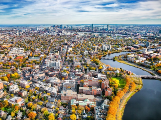
II.Natural Geography
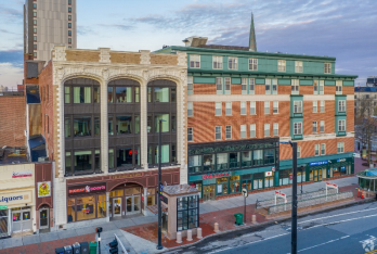
Street View
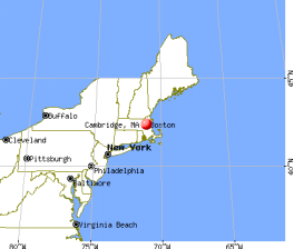
₋Cambridge (/ˈkeɪmbrɪdʒ/ KAYM-brij) is a city in Middlesex County, Massachusetts, and part of the Boston metropolitan area. As of July 2019, it was the fifth most populous city in the state, behind Boston, Worcester, Springfi eld, and Lowell. According to the 2010 Census, the city's population was 105,162. It is one of two de jure county seats of Middlesex County, although the county's government was abolished in 1997. Situated directly north of Boston, across the Charles River, it was named in honor of the University of Cambridge in England, once also an important center of the Puritan theology embraced by the town's founders.
₋Harvard University, the Massachusetts Institute of Technology (MIT), Lesley University, and Hult International Business School are in Cambridge, as was Radcliffe College before it merged with Harvard. Kendall Square in Cambridge has been called "the most innovative square mile on the planet" due to the high concentration of successful startups that have emerged in the vicinity of the square since 2010.
III.ECONOMY
₋The average salary in Cambridge, MA is $87k. Trends in wages decreased by -0.3 percent in Q1 2020. The cost of living in Cambridge, MA is 74 percent higher than the national average. The most popular occupations in Cambridge, MA are Software Engineer, Research Scientist, and Senior Research Scientist, Biotechnology which pay between $50k and $146k per year. The most popular employers in Cambridge, MA are Harvard University, Massachusetts Institute of Technology (MIT), and Takeda Pharmaceuticals.
₋Website: https://www.payscale.com/research/US/Location=Cambridge-MA/Salary
IV.Industrial Characteristics
₋Manufacturing was an important part of Cambridge's economy in the late 19th and early 20th century, but educational institutions are its biggest employers today. Harvard and MIT together employ about 20,000. As a cradle of technological innovation, Cambridge was home to technology firms Analog Devices, Akamai, Bolt, Beranek, and Newman (BBN Technologies) (now part of Raytheon), General Radio (later GenRad), Lotus Development Corporation (now part of IBM), Polaroid, Symbolics, and Thinking Machines.
₋In 1996, Polaroid, Arthur D. Little, and Lotus were Cambridge's top employers, with over 1,000 employees, but they faded out a few years later. Health care and biotechnology firms such as Genzyme, Biogen Idec, bluebird bio, Millennium Pharmaceuticals, Sanofi, Pfizer and Novartis have significant presences in the city. Though headquartered in Switzerland, Novartis continues to expand its operations in Cambridge.
₋Other major biotech and pharmaceutical firms expanding their presence in Cambridge include GlaxoSmithKline, AstraZeneca, Shire, and Pfizer. Most of Cambridge's biotech firms are in Kendall Square and East Cambridge, which decades ago were the city's center of manufacturing. Some others are in University Park at MIT, a new development in another former manufacturing area.
₋None of the high-technology firms that once dominated the economy was among the 25 largest employers in 2005, but by 2008 Akamai and ITA Software were. Google, IBM Research, Microsoft Research, and Philips Research maintain offices in Cambridge. In late January 2012—less than a year after acquiring Billerica-based analytic database management company, Vertica—Hewlett-Packard announced it would also be opening its first offices in Cambridge. Also around that time, e-commerce giants Staples and Amazon.com said they would be opening research and innovation centers in Kendall Square. And LabCentral provides a shared laboratory facility for approximately 25 emerging biotech companies.
₋The proximity of Cambridge's universities has also made the city a center for nonprofit groups and think tanks, including the National Bureau of Economic Research, the Smithsonian Astrophysical Observatory, the Lincoln Institute of Land Policy, Cultural Survival, and One Laptop per Child.[citation needed] A group of start-up companies have emerged in Kendall Square since 2010.
₋In September 2011, the City of Cambridge launched the "Entrepreneur Walk of Fame" initiative. The Walk recognizes people who have made contributions to innovation in global business.
V.Attractions
1.Harvard Museum of Natural History
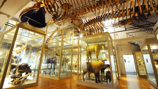
₋The Harvard Museum of Natural History is a natural history museum housed in the University Museum Building, located on the campus of Harvard University in Cambridge, Massachusetts.
₋It displays a sampling of specimens drawn from the collections of the University's three natural history research museums:
the Harvard University Herbaria
the Museum of Comparative Zoology
the Harvard Mineralogical Museum.
The museum is physically connected to the Peabody Museum of Archaeology and Ethnology at 26 Oxford Street. One admission grants visitors access to both museums. In December 2012, Harvard announced a new consortium, the Harvard Museums of Science and Culture, whose members are the Harvard Museum of Natural History, the Semitic Museum, the Peabody Museum, and the Collection of Historical Scientific Instruments.
₋The Harvard Museum of Natural History was created in 1998 as the “public face” of three research museums — the Museum of Comparative Zoology, the Harvard Mineralogical and Geological Museum, and the Harvard University Herbaria. Its exhibitions draw on Harvard University's natural history collections; Harvard's research faculty provides expertise; and programs for members and the general public provide an exchange of information and ideas. With more than 210,000 visitors in 2013, the Harvard Museum of Natural History is the university's most-visited museum. The Harvard Museum of Natural History is one of four public museums which are part of a new consortium created in 2012, the Harvard Museums of Science & Culture.
₋Address: 26 Oxford St, Cambridge, MA 02138, United States
₋Opened: 1995
₋Phone: +1 617-495-3045
₋Website: https://hmnh.harvard.edu/
2.MIT Museum
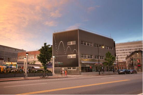
₋The MIT Museum, founded in 1971, is located at the Massachusetts Institute of Technology in Cambridge, Massachusetts. It hosts collections of holography, technology-related artworks, artificial intelligence, robotics, maritime history, and the history of MIT. Its holography collection of 1800 pieces is the largest in the world, though not all of it is exhibited. As of 2019, holographic art, and works by the kinetic artist Arthur Ganson are the two largest long-running displays. There is a regular program of temporary special exhibitions, often on the intersections of art and technology.
₋In addition to serving the MIT community, the museum offers numerous outreach programs to school-age children and adults in the public at large. The widely attended annual Cambridge Science Festival was originated by and continues to be coordinated by the museum.
₋A major expansion program is underway, with expected relocation to a new building in the Kendall Square innovation district in late 2021.
₋The museum was founded in 1971 by Warren Seamans, originally as part of an exhibit project of the Office of the President and the Department of Humanities for the inauguration of President Jerome Wiesner. The committee involved was named the "Historical Collections" in December 1971 and served as the predecessor to the museum. Its purpose was to collect and preserve historical artifacts and documents scattered throughout MIT. It was renamed the "MIT Museum" in 1980, and began developing exhibits and educational programs for the MIT community as well as society at large.
₋Since 2005 the official mission of the MIT Museum has been, "to engage the wider community with MIT’s science, technology and other areas of scholarship in ways that will best serve the nation and the world in the 21st century."
₋The museum is directed by MIT Professor John Durant, and operates under MIT's Associate Provost for the Arts, who also oversees the List Visual Arts Center and the MIT Office of the Arts. Durant is also a faculty member of the MIT School of Humanities, Arts, and Social Sciences (SHASS) in its Program in Science, Technology, and Society (STS). He teaches courses on the development of science exhibits and communication between scientists, engineers, and the general public.
₋The museum was accredited by the organization now called the American Alliance of Museums (AAM) in 1984, and reaccredited in 2002 and 2013. The MIT Museum also belongs to the Association of Science-Technology Centers (ASTC), Museum Computer Network, New England Museum Association, International Confederation of Architectural Museums, and the International Council of Maritime Museums.
₋Address: 265 Massachusetts Ave, Cambridge, MA 02139, United States
₋Phone: +1 617-253-5927
₋Website: https://mitmuseum.mit.edu/
3.Faneuil Hall
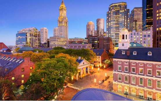
₋Faneuil Hall is a marketplace and meeting hall located near the waterfront and today's Government Center, in Boston, Massachusetts. Opened in 1743, it was the site of several speeches by Samuel Adams, James Otis, and others encouraging independence from Great Britain. It is now part of Boston National Historical Park and a well-known stop on the Freedom Trail. It is sometimes referred to as "the Cradle of Liberty".
₋In 2008, Faneuil Hall was rated number 4 in America's 25 Most Visited Tourist Sites by Forbes Traveler.
₋18th century
₋After the project of erecting a public market house in Boston had been discussed for some years, slave merchant Peter Faneuil offered, at a public meeting in 1740, to build a suitable edifice at his own cost as a gift to the town. There was a strong opposition to market houses, and although a vote of thanks was passed unanimously, his offer was accepted by a majority of only seven. Funded in part by profits from slave trading, the building was begun in Dock Square in September of the same year. It was built by artist John Smibert in 1740–1742 in the style of an English country market, with an open ground floor serving as the market house, and an assembly room above. According to Sean Hennessey, a National Park Service spokesman, some of Boston's early slave auctions took place near Faneuil Hall.
₋In 1761, the hall was destroyed by fire, with nothing but the brick walls remaining. It was rebuilt by the town in 1762. In 1775, during the British occupation of Boston, it was used for a theatre.
₋19th century
₋In 1806, the hall was greatly expanded by Charles Bulfinch, doubling its height and width and adding a third floor. Four new bays were added, to make seven in all; the open arcades were enclosed, and the cupola was moved to the opposite end of the building. Bulfinch applied Doric brick pilasters to the lower two floors, with Ionic pilasters on the third floor. This renovation added galleries around the assembly hall and increased its height. Neighboring Quincy Market was constructed in 1824–1826. Faneuil Hall was entirely rebuilt of noncombustible materials in 1898–1899.
₋20th and 21st centuries
₋On October 9, 1960, the building was designated a National Historic Landmark and added to the National Register of Historic Places following the passage of the National Historic Preservation Act of 1966, which placed all National Historic Landmarks in the National Register. The ground floor and basement were altered in 1979. The Hall was restored again in 1992, and in 1994 the building was designated a local Boston Landmark by the Boston Landmarks Commission.
₋The headquarters of the Ancient and Honorable Artillery Company of Massachusetts is located on the fourth floor and includes an armory, library, offices, quartermaster department, commissary, and a military museum with free admission.
₋Faneuil Hall Marketplace
₋Faneuil Hall is one of four historic buildings in a festival marketplace, Faneuil Hall Marketplace, which includes three historic granite buildings called North Market, Quincy Market, and South Market adjacent to the east of Faneuil Hall, and which operates as an indoor/outdoor mall and food eatery. It was designed by Benjamin Thompson and Associates and managed by Ashkenazy Acquisition Corp.; its success in the late 1970s led to the emergence of similar marketplaces in other U.S. cities.
₋According to Ashkenazy, Faneuil Hall Marketplace had 18 million visitors in 2016.
₋The North and South Markets buildings are currently under study for landmark status by the Boston Landmarks Commission.
₋Address: 4 S Market St, Boston, MA 02109, United States
₋Phone: +1 617-523-1300
₋Website: https://faneuilhallmarketplace.com/
VI.History
₋In December 1630, the site of what would become Cambridge was chosen because it was safely upriver from Boston Harbor, making it easily defensible from attacks by enemy ships. Thomas Dudley, his daughter Anne Bradstreet, and her husband Simon were among the town's first settlers. The first houses were built in the spring of 1631. The settlement was initially referred to as "the newe towne". Official Massachusetts records show the name rendered as Newe Towne by 1632, and as Newtowne by 1638.
₋Located at the first convenient Charles River crossing west of Boston, Newe Towne was one of a number of towns (including Boston, Dorchester, Watertown, and Weymouth) founded by the 700 original Puritan colonists of the Massachusetts Bay Colony under Governor John Winthrop. Its first preacher was Thomas Hooker, who led many of its original inhabitants west in 1636 to found Hartford and the Connecticut Colony; before leaving, they sold their plots to more recent immigrants from England.
₋The original village site is now within Harvard Square. The marketplace where farmers sold crops from surrounding towns at the edge of a salt marsh (since filled) remains within a small park at the corner of John F. Kennedy and Winthrop Streets.
₋The town comprised a much larger area than the present city, with various outlying parts becoming independent towns over the years: Cambridge Village (later Newtown and now Newton) in 1688, Cambridge Farms (now Lexington) in 1712 or 1713, and Little or South Cambridge (now Brighton) and Menotomy or West Cambridge (now Arlington) in 1807. In the late 19th century, various schemes for annexing Cambridge to Boston were pursued and rejected.
₋In 1636, the Newe College (later renamed Harvard College after benefactor John Harvard) was founded by the Massachusetts Bay Colony to train ministers. According to Cotton Mather, Newe Towne was chosen for the site of the college by the Great and General Court (the Massachusetts legislature) primarily for its proximity to the popular and highly respected Puritan preacher Thomas Shepard. In May 1638, the settlement's name was changed to Cambridge in honor of the university in Cambridge, England.
₋Newtowne's ministers, Hooker and Shepard, the college's first president, the college's major benefactor, and the first schoolmaster Nathaniel Eaton were all Cambridge alumni, as was the colony's governor John Winthrop. In 1629, Winthrop had led the signing of the founding document of the city of Boston, which was known as the Cambridge Agreement, after the university. In 1650, Governor Thomas Dudley signed the charter creating the corporation that still governs Harvard College.
₋Cambridge grew slowly as an agricultural village eight miles (13 km) by road from Boston, the colony's capital. By the American Revolution, most residents lived near the Common and Harvard College, with most of the town comprising farms and estates. Most inhabitants were descendants of the original Puritan colonists, but there was also a small elite of Anglican "worthies" who were not involved in village life, made their livings from estates, investments, and trade, and lived in mansions along "the Road to Watertown" (today's Brattle Street, still known as Tory Row).
₋Coming north from Virginia, George Washington took command of the volunteer American soldiers camped on Cambridge Common on July 3, 1775, now reckoned the birthplace of the U.S. Army. Most of the Tory estates were confiscated after the Revolution. On January 24, 1776, Henry Knox arrived with artillery captured from Fort Ticonderoga, which enabled Washington to drive the British army out of Boston.
₋Between 1790 and 1840, Cambridge grew rapidly, with the construction of the West Boston Bridge in 1792 connecting Cambridge directly to Boston, so that it was no longer necessary to travel eight miles (13 km) through the Boston Neck, Roxbury, and Brookline to cross the Charles River. A second bridge, the Canal Bridge, opened in 1809 alongside the new Middlesex Canal. The new bridges and roads made what were formerly estates and marshland into prime industrial and residential districts.
₋Soon after, turnpikes were built: the Cambridge and Concord Turnpike (today's Broadway and Concord Ave.), the Middlesex Turnpike (Hampshire St. and Massachusetts Ave. northwest of Porter Square), and what are today's Cambridge, Main, and Harvard Streets connected various areas of Cambridge to the bridges. In addition, the town was connected to the Boston & Maine Railroad, leading to the development of Porter Square as well as the creation of neighboring Somerville from the formerly rural parts of Charlestown.
₋Cambridge was incorporated as a city in 1846 despite persistent tensions between East Cambridge, Cambridgeport, and Old Cambridge stemming from differences in culture, sources of income, and the national origins of the residents. The city's commercial center began to shift from Harvard Square to Central Square, which became the city's downtown around that time.
₋Between 1850 and 1900, Cambridge took on much of its present character—streetcar suburban development along the turnpikes, with working-class and industrial neighborhoods focused on East Cambridge, comfortable middle-class housing on the old Cambridgeport and Mid-Cambridge estates, and upper-class enclaves near Harvard University and on the minor hills. The coming of the railroad to North Cambridge and Northwest Cambridge led to three major changes: the development of massive brickyards and brickworks between Massachusetts Ave., Concord Ave. and Alewife Brook; the ice-cutting industry launched by Frederic Tudor on Fresh Pond; and the carving up of the last estates into residential subdivisions to house the thousands of immigrants who arrived to work in the new industries.
₋For many decades, the city's largest employer was the New England Glass Company, founded in 1818. By the middle of the 19th century, it was the world's largest and most modern glassworks. In 1888, Edward Drummond Libbey moved all production to Toledo, Ohio, where it continues today under the name Owens-Illinois. The company's flint glassware with heavy lead content is prized by antique glass collectors. There is none on public display in Cambridge, but the Toledo Museum of Art has a large collection. The Museum of Fine Arts, Boston and the Sandwich Glass Museum on Cape Cod also have a few pieces.
₋In 1895, Edwin Ginn founder of Ginn and Company built the Athenaeum Press Building for his publishing text book empire.
₋By 1920, Cambridge was one of New England's main industrial cities, with nearly 120,000 residents. Among the largest businesses in Cambridge during the period of industrialization was Carter's Ink Company, whose neon sign long adorned the Charles River and which was for many years the world's largest ink manufacturer. Next door was the Athenaeum Press. Confectionery and snack manufacturers in the Cambridgeport-Area 4-Kendall corridor included the Kennedy Biscuit Factory (later part of Nabisco and originator of the Fig Newton), Necco, Squirrel Brands, George Close Company (1861–1930s), Page & Shaw, Daggett Chocolate (1892–1960s, recipes bought by Necco), Fox Cross Company (1920–1980, originator of the Charleston Chew, and now part of Tootsie Roll Industries), Kendall Confectionery Company, and James O. Welch (1927–1963, originator of Junior Mints, Sugar Daddies, Sugar Mamas and Sugar Babies, now part of Tootsie Roll Industries).
₋Only the Cambridge Brands subsidiary of Tootsie Roll Industries remains in town, still manufacturing Junior Mints in the old Welch factory on Main Street. The Blake and Knowles Steam Pump Company (1886), the Kendall Boiler and Tank Company (1880, now in Chelmsford, Massachusetts) and the New England Glass Company (1818–1878) were among the industrial manufacturers in what are now Kendall Square and East Cambridge.
₋As industry in New England began to decline during the Great Depression and after World War II, Cambridge lost much of its industrial base. It also began to become an intellectual, rather than an industrial, center. Harvard University had always been important as both a landowner and an institution, but it began to play a more dominant role in the city's life and culture. When Radcliffe College was established in 1879 the town became a mecca for some of the nation's most academically talented female students. The Massachusetts Institute of Technology's move from Boston in 1916 reinforced Cambridge's status as an intellectual center of the United States.
₋After the 1950s, the city's population began to decline slowly as families tended to be replaced by single people and young couples. In Cambridge Highlands, the technology company Bolt, Beranek, & Newman produced the first network router in 1969, and hosted the invention of computer-to-computer email in 1971. The 1980s brought a wave of high-technology startups. Those selling advanced minicomputers were overtaken by the microcomputer.[citation needed] Cambridge-based VisiCorp made the first spreadsheet software for personal computers, Visicalc, and helped propel the Apple II to major consumer success. It was overtaken and purchased by Cambridge-based Lotus Development, maker of Lotus 1-2-3. (This was in turn replaced in the market by Microsoft Excel).
₋The city continues to be home to many startups. Kendall Square was a major software hub through the dot-com boom and today hosts offices of such technology companies as Google, Microsoft, and Amazon. The Square also now houses the headquarters of Akamai.
₋In 1976, Harvard's plans to start experiments with recombinant DNA led to a three-month moratorium and a citizen review panel. In the end, Cambridge decided to allow such experiments but passed safety regulations in 1977. This led to regulatory certainty and acceptance when Biogen opened a lab in 1982, in contrast to the hostility that caused the Genetic Institute (a Harvard spinoff) to abandon Somerville and Boston for Cambridge. The biotech and pharmaceutical industries have since thrived in Cambridge, which now includes headquarters for Biogen and Genzyme; laboratories for Novartis, Teva, Takeda, Alnylam, Ironwood, Catabasis, Moderna Therapeutics, Editas Medicine; support companies such as Cytel; and many smaller companies.
₋By the end of the 20th century, Cambridge had one of the most costly housing markets in the Northeastern United States. While considerable class, race, and age diversity persisted, it became harder for those who grew up in the city to afford to stay. The end of rent control in 1994 prompted many Cambridge renters to move to more affordable housing in Somerville and other cities or towns.
₋Until recently, Cambridge's mix of amenities and proximity to Boston kept housing prices relatively stable despite the bursting of the United States housing bubble. Cambridge has been a sanctuary city since 1985 and reaffirmed its status as such in 2006.
VII.Other Information
₋Road
₋Several major roads lead to Cambridge, including Route 2, Route 16 and the McGrath Highway (Route 28). The Massachusetts Turnpike does not pass through Cambridge, but provides access by an exit in nearby Allston. Both U.S. Route 1 and Interstate 93 also provide additional access on the eastern end of Cambridge at Leverett Circle in Boston. Route 2A runs the length of the city, chiefly along Massachusetts Avenue. The Charles River forms the southern border of Cambridge and is crossed by 11 bridges connecting Cambridge to Boston, including the Longfellow Bridge and the Harvard Bridge, eight of which are open to motorized road traffic.
₋Cambridge has an irregular street network because many of the roads date from the colonial era. Contrary to popular belief, the road system did not evolve from longstanding cow-paths. Roads connected various village settlements with each other and nearby towns, and were shaped by geographic features, most notably streams, hills, and swampy areas. Today, the major "squares" are typically connected by long, mostly straight roads, such as Massachusetts Avenue between Harvard Square and Central Square, or Hampshire Street between Kendall Square and Inman Square.
₋Mass transit
₋Cambridge is served by the MBTA, including the Porter Square Station on the regional Commuter Rail; the Lechmere Station on the Green Line; and the Red Line at Alewife, Porter Square, Harvard Square, Central Square, and Kendall Square/MIT Stations. Alewife Station, the terminus of the Red Line, has a large multi-story parking garage (at a rate of $7 per day as of 2015).
₋The Harvard bus tunnel, under Harvard Square, connects to the Red Line underground. This tunnel was originally opened for streetcars in 1912, and served trackless trolleys (trolleybuses) and buses as the routes were converted; four lines of the MBTA trolleybus system continue to use it. The tunnel was partially reconfigured when the Red Line was extended to Alewife in the early 1980s.
₋Besides the state-owned transit agency, the city is also served by the Charles River Transportation Management Agency (CRTMA) shuttles which are supported by some of the largest companies operating in city, in addition to the municipal government itself.
₋Cycling
₋Cambridge has several bike paths, including one along the Charles River, and the Linear Park connecting the Minuteman Bikeway at Alewife with the Somerville Community Path. A connection to Watertown is under construction. Bike parking is common and there are bike lanes on many streets, although concerns have been expressed regarding the suitability of many of the lanes. On several central MIT streets, bike lanes transfer onto the sidewalk. Cambridge bans cycling on certain sections of sidewalk where pedestrian traffic is heavy.
₋While Bicycling Magazine in 2006 rated Boston as one of the worst cities in the nation for bicycling, it has given Cambridge honorable mention as one of the best and was called by the magazine "Boston's Great Hope". Boston has since then followed the example of Cambridge, and made considerable efforts to improve bicycling safety and convenience.
₋Cambridge has an official bicycle committee. The LivableStreets Alliance, headquartered in Cambridge, is an advocacy group for bicyclists, pedestrians, and walkable neighborhoods.
₋Walking
₋Walking is a popular activity in Cambridge. In 2000, among US cities with more than 100,000 residents, Cambridge had the highest percentage of commuters who walked to work. Cambridge's major historic squares have changed into modern walking neighborhoods, including traffic calming features based on the needs of pedestrians rather than of motorists.
₋Intercity
₋The Boston intercity bus and train stations at South Station, Boston, and Logan International Airport in East Boston, are accessible by subway. The Fitchburg Line rail service from Porter Square connects to some western suburbs. Since October 2010, there has also been intercity bus service between Alewife Station (Cambridge) and New York City.
₋Police department
₋In addition to the Cambridge Police Department, the city is patrolled by the Fifth (Brighton) Barracks of Troop H of the Massachusetts State Police. Due, however, to close proximity, the city also practices functional cooperation with the Fourth (Boston) Barracks of Troop H, as well. The campuses of Harvard and MIT are patrolled by the Harvard University Police Department and MIT Police Department, respectively.
₋Fire department
₋The city of Cambridge is protected by the Cambridge Fire Department. Established in 1832, the CFD operates eight engine companies, four ladder companies, one rescue company, and two paramedic squad companies from eight fire stations located throughout the city. The Acting Chief is Gerard Mahoney.
₋Water department
₋Cambridge obtains water from Hobbs Brook (in Lincoln and Waltham) and Stony Brook (Waltham and Weston), as well as the Massachusetts Water Resources Authority. The city owns over 1,200 acres (486 ha) of land in other towns that includes these reservoirs and portions of their watershed. Water from these reservoirs flows by gravity through an aqueduct to Fresh Pond in Cambridge. It is then treated in an adjacent plant and pumped uphill to an elevation of 176 feet (54 m) above sea level at the Payson Park Reservoir (Belmont). The water is then redistributed downhill via gravity to individual users in the city. A new water treatment plant opened in 2001.
₋In October 2016, the City of Cambridge announced that, due to drought conditions, they would begin buying water from the MWRA. On January 3, 2017, Cambridge announced that "As a result of continued rainfall each month since October 2016, we have been able to significantly reduce the need to use MWRA water. We have not purchased any MWRA water since December 12, 2016 and if 'average' rainfall continues this could continue for several months."
₋Public library services
₋Further educational services are provided at the Cambridge Public Library. The large modern main building was built in 2009, and connects to the restored 1888 Richardson Romanesque building. It was founded as the private Cambridge Athenaeum in 1849 and was acquired by the city in 1858, and became the Dana Library. The 1888 building was a donation of Frederick H. Rindge.
VIII.Contact Information
Government
Type: Council-City Manager
Mayor: Sumbul Siddiqui (D)
City Hall
Physical Address:
795 Massachusetts Ave.
Cambridge, MA 02139
Ph: 617-349-4000
TTY: 617-349-4242
Opening Hours:
Mon: 8:30 a.m. - 8:00 p.m.
Tue - Thu: 8:30 a.m. - 5:00 p.m.
Fri: 8:30 a.m. - 12:00 p.m.
Website: https://www.cambridgema.gov/Departments/citymanagersoffice/contactus/contactus
