Ciudad Valles, San Luis Potosí 作者: 来源: 发布时间:2021-11-19
1.Population and Area
Pop: 124,644 (city)
Area: 2.396 km2 (city)
Elev: 83 masl
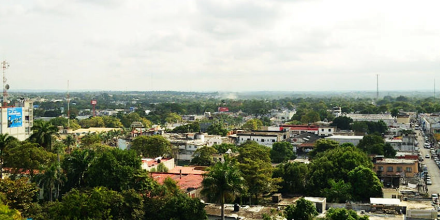
2. Natural geography
Nature and weather
Orography
Cruz River, which forms in the United States, penetrates to Mexican territory, joining the streams of Terrenate and Cuitaca, crossing the border on a near side of Nogales; it returns to the Arizona territory, where it joins the San Pedro, as a tributary of the Gila River.
Hydrography
The El Salto or Naranjo and El Gato rivers enter the northern part, which join to form the Valles river.
The Valles River passes through the eastern portion and the Coy River is located in the southeast. To the north are the Ciénega and Las Lajitas lagoons that come from an intermittent stream called Arroyo Grande.
Flora and fauna
The vegetation type in the red cedar forest are tropical common woods, tulars, and palms.
The fauna is characterized by the dominant species such as: songbirds, hare, armadillo, opossum, rabbit and lizard.
The municipality has "El Abra Tanchipa", as a protected natural area with a decree of 1994 as a biosphere reserve, with an area of 21,464.00 hectares, including the municipality of Tamuín.
Köppen Classification: Humid Subtropical Climate
This climate is characterized by relatively high temperatures and evenly distributed precipitation throughout the year. This climate type is found on the eastern sides of the continents between 20° and 35° N and S latitude. In summer, these regions are largely under the influence of moist, maritime airflow from the western side of the subtropical anticyclonic cells over low-latitude ocean waters. Temperatures are high and can lead to warm, oppressive nights. Summers are usually somewhat wetter than winters, with much of the rainfall coming from convectional thunderstorm activity; tropical cyclones also enhance warm-season rainfall in some regions. The coldest month is usually quite mild, although frosts are not uncommon, and winter precipitation is derived primarily from frontal cyclones along the polar front.
The Köppen Climate Classification subtype for this climate is "Cfa". (Humid Subtropical Climate).
The average temperature for the year in Ciudad Valles - Vergel is 76.6°F (24.8°C). The warmest month, on average, is June with an average temperature of 85.1°F (29.5°C). The coolest month on average is January, with an average temperature of 65.1°F (18.4°C).
The highest recorded temperature in Ciudad Valles - Vergel is 122.0°F (50°C), which was recorded in June. The lowest recorded temperature in Ciudad Valles - Vergel is 28.4°F (-2°C), which was recorded in January.
The average amount of precipitation for the year in Ciudad Valles - Vergel is 48.9" (1242.1 mm). The month with the most precipitation on average is September with 9.3" (236.2 mm) of precipitation. The month with the least precipitation on average is February with an average of 0.7" (17.8 mm). In terms of liquid precipitation, there are an average of 95.8 days of rain, with the most rain occurring in September with 13.0 days of rain, and the least rain occurring in March with 5.1 days of rain.
http://www.weatherbase.com/weather/weather-summary.php3?s=924012&cityname=Ciudad+Valles+-+Vergel%2C+San+Luis+Potosi%2C+Mexico&units=
Getting there and around
Get there
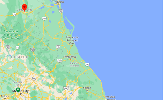
By plane – The quickest way to get from Mexico City to Ciudad Valles is to fly and bus which costs $1700 - $3800 and takes 5h 53m. The quickest flight from Mexico City Airport to Tampico Airport is the direct flight which takes 1h.
By car – The distance between Mexico City and Ciudad Valles is 286 km. The road distance is 405.8 km. It takes approximately 6h 8m to drive from Mexico City to Ciudad Valles.
By bus – The cheapest way to get from Mexico City to Ciudad Valles is to bus via Xilitla which costs $597 - $599. There are services departing from Izazaga and arriving at Ciudad Valles via México Central Norte and Xilitla. The journey, including transfers, takes approximately 12h 10m.
https://wikitravel.org/en/Nogales_(Mexico)
Rideshare – Check out Blabla Car's carpooling service for rideshare options between Mexico City and the city you are visiting. A great option if you don't have a driver's license or want to avoid public transport.
Car Rental – To explore Mexico’s provincial towns and cities—including its beach locations and the scenery and attractions near them— consider renting a car for your visit. Having your own car will give you more flexibility than using public transport options and, in some cases, offer you access to places which are otherwise difficult to visit without the use of a car.
COVID19 – International entry into Mexico from United States
Allowed for: All visitors arriving by air. Mexico land borders are closed to non-essential travel
Restricted for: There are no current restrictions.
Get around
Local Buses – Local buses and mini-buses (combis or micros) are available locally for a fraction of the cost of a taxi around town. You need to speak Spanish to be able to ask for directions or ask the driver to tell you where to get off.
Taxis – Taxis in most of Mexico’s towns and cities are not metered, so agree your price before you get in. Taxi travel is very affordable in Mexico, in comparison to the USA, Canada and Europe, and so provides a viable means of public transportation in Mexico. Your hotel can arrange taxis for you; some post their rates on a board in the lobby; taxi hotel rates are usually higher than cabs you hail off the street. If you speak Spanish, you will have a distinct advantage and be able to negotiate a price with the driver.
Uber is expanding rapidly across Mexico and now offers services in cities across the country, including: Mexico City, Toluca, Cuernavaca, Puebla, Querétaro, León, Aguascalientes, San Luis Potosí, Guadalajara, Monterrey, Hermosillo, Tijuana, Mexicali, and Mérida. Uber has been adding Mexican cities to its network every year, check for availability when you arrive at your destination in Mexico.
Cabify and Didi are also developing and currently operate in cities including Mexico City, Toluca, Monterrey, Puebla, Querétaro and Tijuana. Check for availability in the city you are visiting.
These services offer people with smartphones a way to book a cab through a mobile app for a pre-agreed price. Fares are comparable with Sitio type cabs, and sometimes trade at a premium to this when local demand increases.
https://www.mexperience.com/transport/taxi-travel-in-mexico/#51
3. ECONOMY
GDP: 11,257 M MXN (2010)
https://www.researchgate.net/publication/323024280_El_producto_interno_bruto_de_los_municipios_de_Mexico_II_Estados_M-Z
4. Industry characteristics
The city has the highest gross income annually, only behind the Capital Potosina and Soledad de Graciano Sánchez in 2013 produced 472,375 thousand pesos for the state that produced a total of 7,343,777 thousand pesos.
Farming
The arable lands of the municipality are dedicated mainly to the production of sugar cane. There is a fruit production of lemon, lychee, mango and orange. Also cultivated are coffee cherries, beans, grain corn, nopal and aloe vera. The city has 41,707 hectares of planted area, of which 36,875 hectares are harvested and in the state there are 645,017 hectares of which 450,307 hectares are harvested.
Cattle raising
Beekeeping and poultry farming is exploited in the municipality; cattle and pigs.
Mining
In the municipality of Ciudad Valles there are quarry, kaolin, flagstones, topaz and zeolite deposits.
Fishing
It benefits from catching, carp and tilapia.
5. Attractions
Tamtoc Archaeological Site
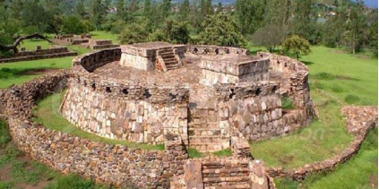
A trip to the Archeological Site Tamtoc is a must while you are visiting Ciudad Valles. Walk through the prehispanic constructions of this place which is also called “The Place of Water Clouds”.
While you are here, you will feel as if you are going back in time when you discover more than 70 structures perfectly preserved of about 36 and 21 meters in height.
Tamtoc was considered once the capital of the Huasteca Potosina during its heyday in the years 600 to the 1100 AD.
During spring, different rituals and dances take place in order to welcome the season. If you come during this time, you will find chamanes that offer limpias for preventing evil's eye.
https://www.visitmexico.com/en/san-luis-potosi/ciudad-valles/zona-arqueologica-de-tamtoc
Minas Viejas (Old Mines Waterfall)
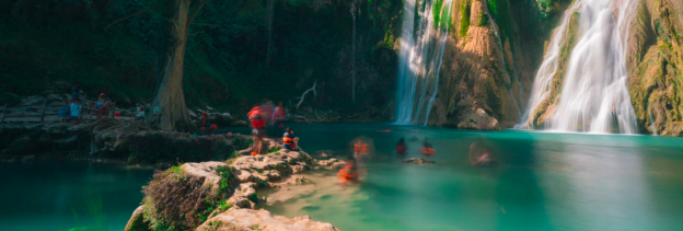
Just 23 kilometers from Ciudad Valles, you will find Minas Viejas, a waterfall of 50 meters in height. It is possible to swim in its natural pools of crystalline water.
If you like adventures, you will enjoy the experience of descending the waterfall doing rappel. You can also explore the roads until you find two wood bridges for crossing the river.
For enjoying a night under a starry sky in the Huasteca Potosina you can camp at Minas Viejas or rent a cottage. You will enjoy the sound of the water falling like lullabies in the night.
Regional Huasteca Museum Joaquín Meade
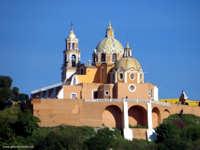
We strongly advise you that the first stop you do in Ciudad Valles be to The Regional Huasteca Museum, located in Artes y José Peñalosa 623. You will gain a deeper understanding of the community here.
It was designed by the teacher Oralia Gutiérrez. This enclosure was born with the idea of preserving and explaining the historical inheritance of the area. After the construction of the México-Laredo highway, Gutiérrez realized that the travelers from all over the world could get archaeological pieces from the place, sometimes as gifts. Because of this, she built this museum in 1978 with the idea of safeguarding the Mexican patrimony.
Through the collection that is displayed in the museums, visitors can go deeper into the knowledge of the huasteca culture that took place during the year 600 BC. up until the arrival of the Spaniards. Noteworthy pieces in the collection are jewelry made of shell and chest ornaments with representation of important gods.
The museum offers lectures, workshops, photographic and painting expositions and short courses around the importance of ancient civilization at the Huasteca.
Sierra de Abra-Tanchipa Biosphere Reserve
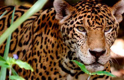
There is no better place to observe the flora and fauna of Ciudad Valles than in the Reservoir of the Biosphere Sierra de Abra-Tanchipa. This place is part of the Corridor Ecológico de la Sierra Madre Oriental.
Once you are inside these tropical forests, you will be able to see some of the most emblematic species of the region like the jaguar, the white tail rabbit, the green winged macaw or the wild pig.
The richness of this biosphere is impressive. It concentrates more than 231 species of plants, like the orchid, the palmilla and the soyante, which can live for hundreds of years. Talking about the fauna, there is a register of 161 species, most of them birds, mammals, reptiles and amphibians.
Besides admiring the great biodiversity of this zone, this reservoir has a big cultural and anthropological value, due that during a long time many human settlements inhabited this place in the Huasteca.
Throughout its territory, there are 17 archeological sites identified. Some of the most relevant are Cerro Alto, Vista Hermosa, Tampacuala and probably the most impressive of all the ceremonial center La Hondurada.
If you are seeking adventure, you can always visit one of its caves and caverns like Corinto o Tanchipa. You will be able to see ancient petroglyphs and some carved stones.

D Todo - Ciudad Valles, S.L.P (17/09/2019)
https://youtu.be/XsbaO81vOaA
6. History
The city is in the area originally inhabited by the Huasteco people, also called Huaxteca or Teenek. Founded in the 16th century by the conqueror Nuño de Guzmán on July 25, 1533 with the name of "Villa de Santiago de Los Valles de Oxitipa" (near Aquismón, SLP and El Tanute, SLP, but they had to change the headquarters to current place, due to a fire caused by the Chichimeca War, unleashed first against the Aztecs who had Huaxteca regions in power and then against the Spanish colonizers). The foundation of this place was carried out with 25 residents and the first commissioner commissioned by the government of the same was Francisco Barrón. Since the nineteenth century, the abbreviated name has been more widely used, eventually becoming the official name Ciudad Valles. The indigenous name of the current Ciudad Valles was "Tamtokow bichou" which in the Teenek language means "People of the place of clouds"; Spaniards and mestizos (ladinos) used to write "Tantocob" as a reference to the original name.
The history of Valles in the 16th and 17th centuries is properly the relationship of the mayors of this Villa. The first mayor was Juan de Trejo Meraz between the years 1578 to 1581, being at that time when the Mayor's Office of Santiago de los Valles reached its greatest extension.
During the 19th and early 20th centuries, it was the scene of skirmishes of secondary importance during the numerous civil wars that ravaged the country. By decree it was assigned the rank of city, for being the jurisdictional head in the 19th century. With little economic and demographic importance for centuries, being mainly a place of passage between the mining capital city of San Luis Potosí and the port of Tampico. Population growth occurred primarily as a result of the installation of sugar mills in the region, in the mid-1950s of the 20th century.
The State Legislature in its decree No. 60 of October 5, 1827, ordered that all the heads of the Department and Party be called Cities. For this reason, from that date, the old Villa de los Valles, became Ciudad Valles.
In 1920 the electrical energy arrived in Ciudad Valles, the Engineers Rómulo Meraz and Ángel Oliva installed a small power plant that could barely supply a few places in the city, producing around 8 kilowatts of power, after which they formed a partnership with Sabas Flores and achieved build a stronger installation that produced 50 kilowatts of electric fluid, and several years later the Engineer Mario Villa Salgado founded the Central Hidroeléctrica del Río Micos SA reaching figures of 3000 kilowatts of power, becoming the first distributors of electric power in Ciudad Valles.
The Shield of Ciudad Valles was designed by Professor Oralia Gutiérrez de Sánchez, founder of the Museo Regional Huasteco based in Ciudad Valles, which houses one of the three most important collections of pre-Hispanic objects in the world in the hands of a civil society.
7. Other Information: Ciudad Valles and the Huasteca Potosina
Ciudad Valles is part of an emblematic region known as Huasteca Potosina. The Huasteca Potosina is made up of 20 municipalities, it is a region of warm and low lands that extends off the coast of the Gulf of Mexico, with a slight inclination towards the east, which is why it covers some portions of the Sierra Madre Oriental, its name It is derived from the Huastecos, inhabitants of the area in pre-Hispanic times. It has several places of great attraction, places of exuberant vegetation, intense humidity that favors the existence of numerous natural landscapes such as rivers, lagoons, waterfalls, springs, basements, caves, etc.
The great cultural diversity of the Huasteca Potosina is preserved to this day, made up of important groups of more than 250,000 inhabitants who speak Nahuatl, Tenek and Pame. The main sites of interest in the Huasteca Potosina are the Tamul Waterfall, the Puente de Dios, Las Pozas and the Sótano de las Golondrinas.
Although others such as Cascada de Minas Viejas, Cascada El Salto, Cascadas de Tamasopo, Cascadas de Micos and Tamtoc also stand out, the latter being the most important and recognized archaeological site in the region.
8. Contact Information

City Mayor: Adrián Esper Cárdenas
Phone number: +52 (481) 382 0316
Facebook: https://www.facebook.com/AdrianEsperCardenas
Twitter: https://twitter.com/AdrianEsperSLP
Website: https://vallesslp.gob.mx
Govt. Office Address: Privada de Juárez S/N, Centro, C.P. 79000 Cd. Valles, S.L.P
