Cavan, Province of Ulster ,Ireland 作者: 来源: 发布时间:2021-01-21
I. Population and Area
Population in 2011:64,825
Population in 2016: 76,176
Population Density: 39 persons per square kilometre
Total Area: 745.95 sq miles
II. Natural Geography (Environment, resource and transportation)

Cavan shares a 70 km (43 mi) border with County Fermanagh in Northern Ireland. Cavan is the 19th largest of the 32 counties in area and the 25th largest by population.It is also the sixth largest of Ulster’s nine counties in size and the seventh largest by population.
The minerals are iron, lead, silver, coal, ochres, marl, fullers' earth, potters' clay, brick clay, manganese, sulphur, and a species of jasper. Limestone and various kinds of good building stone are also procured, especially in the north-western extremity of the county, which comprises the eastern part of the great Connaught coal field.
Transportation:
Two national primary routes pass through the county, The N3 road and the N16 road. The N3 is the longest route in Cavan, crossing the county for 60 km (37 mi) from the Meath border at Whitegate near Virginia and through Belturbet into Fermanagh. The N16 begins in Sligo and ends at Blacklionin the far northwestern tip of Cavan, it crosses the county for roughly 7 km (4.3 m).Three national secondary routes pass through the county. The N87 road begins in Belturbet and passes through Ballyconnell and Swanlinbar before crossing into County Fermanagh where it becomes the A32. The N54 route from Monaghan and Clones joines the N3 at Butlersbridge. The N55 links Cavan to the large town of Athlone via Ballinagh and Granard.
Bus Éireann provide bus services to villages and towns across the county, including a direct route from Cavan to Dublin Airport.
ww.visual-arts-cork.com/ireland-art-and-culture/cavan.htm
III. Economy
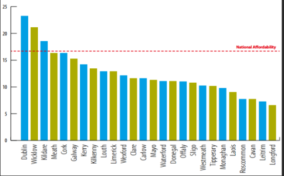
The cost of living

IV. Industrial Characteristics:
1) CavMac Hose Manufacturers
Abcon Industrial Products Ltd manufactures the high quality and reliable CavMac brand of Industrial Mandrel Built Hose Assemblies and is based in Ireland. CavMac Industrial Hose has been manufactured on the same site since 1977 and our products have been shipped to customers worldwide for 37 years. Our Hose Assemblies are used for the safe transport of a range of products including liquids in the oil and gas industries. Our expert team specializes in focusing on our customers’ individual specifications and needs. All CavMac products are designed, manufactured and tested in full compliance with accepted industry standards.
The wide range of CavMac Hose Assemblies include Dock loading Hoses (EN1762 and EN1765 for petroleum or LPG products), Dump Hoses, Water Uptake Hoses, Jumper Hose Assemblies, Bunkering Hoses, Drilling Mud Transport Hoses, Compensator Hoses and Roof Drain Hoses. Each product is true to our promise of compliance with industry standards and long life, which result in cost benefits for our customers. Combined with our customer service and technical expertise, this ensures long term satisfaction with their CavMac Hose.
If you have any questions at all, we would be delighted to hear from you. Please contact us at sales@cavmac.com
V. Attractions:

Killeshandra or Killashandra, is a village in County Cavan, Ireland. It is 20 kilometres northwest of Cavan Town in the centre of County Cavan's lakeland and geopark region and the Erne catchment environment of rivers, lakes, wetlands and woodland. Together with the Lough Oughter Special Protected Area, it has been recognised by the EU programme for wildlife Natura 2000 since 2010. Killeshandra is noted by Fáilte Ireland as an "Angling Centre of Excellence", and as a hub for the Cavan Walking Festival which takes place in May each year. There are several looped walking and cycling trails in Killykeen Forest Park. The town is also home to Killeshandra Gaelic Football Club, known locally as the Killeshandra Leaguers.

Shannon Erne Waterway Flanked by lush riverside pastures, the Shannon-Erne Waterway is 63km of river, lake and still- water canal. Between Leitrim Village and just north of Belturbet, the Shannon- Erne Waterway links the two great waterways on the island, the historical Erne System and the colourful Shannon Navigation.
VI. History
In medieval times, the area of Cavan was part of the petty kingdomof East Bréifne or Brefney O’Reilly after its ruling Gaelic family. This in turn was a division of the 11th century Kingdom of Bréifne. For this reason the county is colloquially known as the BreffniCounty. A high degree of defence was achieved by using the natural landscape of drumlin hills and loughs. The poorly drained heavy clay soils contributed as an obstacle against invasion.Historically, Cavan was part of the western province of Connacht, but was transferred to Ulster in 1584 when Bréifne was shired and became the county of Cavan. In the south, the Lough Sheelin area was part of Leinster until the late 14th century.
Parts of Cavan were subjected to Norman influence from the twelfth century and the remains of several motte and bailie fortifications are still visible mainly in the east of the county, as well as the remains of stronger works such as Castlerahan and Clogh Oughter castle. The influence of several monastic orders also owes its origins to around this time with abbey remains existent in locations such as Drumlane and Trinity Island.
The Plantation of Ulster from 1610 saw the settlement and origins of several new towns within the county that include Bailieborough, Cootehill, Killeshandra and Virginia. Existing towns such as Cavan and Belturbet became over time more important as trading centres. Wars aimed at trying to unsettle the Plantation only led to further plantations of English and Scottish settlers into the county and the beginnings of a thriving flax and linen industry.
Some areas of Cavan were hard hit by the Great Famine potato blight between 1845-49. The winter of 1847 is particularly noted for the high levels of deaths nationally caused by diseases such as typhus and cholera. Several instances of eviction also occurred during the nineteenth century, with one such story where the local landlord in Mountnugent parish decided to evict over 200 people. The famous ballad “By Lough Sheelin Side” is based on this event witnessed by the local Catholic priest.
Reference website: https://www.familysearch.org/wiki/en/County_Cavan,_Ireland_Genealogy
VII. Other information
The county is characterised by drumlincountryside dotted with many lakes and hills. The north-western area of the county is sparsely populated and mountainous. The Breifne mountains contains the highest point, Cuilcagh at 665 metres (2,182 feet).Cavan is the source of many rivers in Ireland. Shannon Pot on the slopes of Culicagh is the source of the River Shannon, the longest river in Ireland at 386 km (240 mi). The River Erne is a major river which rises from Beaghy Lough, two miles (3 km) south of Stradone in Cavan and flows for 120 km (75 mi) to Lough Erne. Other rivers in the county include the Blackwater River from Lough Ramor which joins the River Boyne at Navan. the Dee which springs near Bailieborough, the River Annalee which flows from Lough Sillan and joins the Erne, the Cladagh river rises from Culicagh and flows into Fermanagh. The Glyde and the Owenroe also source in Cavan.
Cavan is known as ‘The Lakeland County’ and is reputed to contain 365 lakes. At 18.8 km2 (7.3 sq mi), Lough Sheelin is the county’s largest lake situated in the south of the county and forms a three way border on its waters between counties Meath and Westmeath and Cavan.
A large complex of lakes form in the north and west of Cavan into designated Specially Protected Areas (SPA), example of this being Lough Oughter. Other important wildlife protected lakes such as Lough Gowna and Lough Ramor are in the south and east of the county. Cavan has a mainly hilly (drumlin) landscape and contains just under 7,000 hectares (17,000 acres) of forested area, 3.6% of Cavan’s total land area. The county contains forests such as Bellamont Forest near Cootehill, Killykeen Forest Park at Lough Oughter (a Coillte state forest concern), Dún na Rí Forest Park and the Burren Forest.
VIII. Contact information
Mayor: John Paul Feeley
Address: Courthouse
Farnham Street
Cavan H12 R6V2
· Party: Fianna Fáil
· Tel: 071-9853125
· Mobile: 087-6989304
· Email: jpfeeley@cavancoco.ie
Reference website: http://www.cavancoco.ie/Default.aspx?StructureID_str=255&guid=2826
