Drogheda,Leinster 作者: 来源: 发布时间:2021-06-16
I.Population and Area
Location in Ireland
Coordinates: 53.714°N 6.350°W
Country Ireland
Province Leinster
County County Louth and County Meath
Municipal district Drogheda Borough District
Dáil Éireann Louth
EU Parliament Midlands–North-West
Founded 911 AD
First Charter 1194
County Status 1412 (Abolished 1898)
Area
• Total 14.8 km2 (5.7 sq mi)
Highest elevation 24 m (79 ft)
Lowest elevation 1 m (3 ft)
Population (2016)
• Total 40,956
• Rank 6th
• Density 2,776.6/km2 (7,191/sq mi)
• Greater area 83,000
Demonyms Droghedean, Boynesider
Time zone UTC±0 (WET)
• Summer (DST) UTC+1 (IST)
Eircode routing key A92
Telephone area code +353(0)41
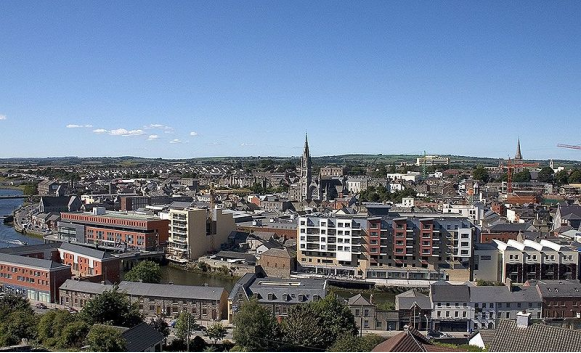
Drogheda meaning "bridge at the ford" is one of the oldest towns in Ireland. It is located on the Dublin–Belfast corridor on the east coast of Ireland, mostly in County Louth but with the south fringes of the town in County Meath, 49 km or 30 miles north of Dublin. Drogheda has a population of approximately 41,000 inhabitants (2016), making it the eleventh largest settlement by population in all of Ireland. It is the last bridging point on the River Boyne before it enters the Irish Sea. The UNESCO World Heritage Site of Newgrange is located 8 km west of the town.
Drogheda was founded as two separately administered towns in two different territories: Drogheda-in-Meath (i.e. the Lordship and Liberty of Meath, from which a charter was granted in 1194) and Drogheda-in-Oriel (or 'Uriel', as County Louth was then known). The division came from the twelfth-century boundary between two Irish kingdoms, colonised by different Norman interests, just as the River Boyne continues to divide the town between the dioceses of Armagh and Meath. In 1412 these two towns were united, and Drogheda became a 'County Corporate', styled as 'the County of the Town of Drogheda'. Drogheda continued as a County Borough until the setting up of County Councils through the enactment of the Local Government (Ireland) Act 1898, which saw all of Drogheda, including a large area south of the Boyne, become part of an extended County Louth. With the passing of the County of Louth and Borough of Drogheda (Boundaries) Provisional Order, 1976, County Louth again grew larger at the expense of County Meath. The boundary was further altered in 1994 by the Local Government (Boundaries) (Town Elections) Regulations 1994. The 2007–2013 Meath County Development Plan recognises the Meath environs of Drogheda as a primary growth centre on a par with Navan.
The town was selected to host Fleadh Cheoil na hÉireann for two years in 2018.
II.Natural Geography (environment and resources)
Demographics
Drogheda has a hinterland of 70,000+ within a 15 kilometres (9.3 mi) radius covering County Louth and County Meath.[citation needed] According to the 2016 census, there were 40,956 people living in Drogheda town at that time.
As of the 2011 census, non-Irish nationals accounted for 16.1% of the population, compared with a national average of 12%. Polish nationals (1,127) were the largest group, followed by Lithuanian nationals (1,044 people). As of the 2016 census, 17.4% of the population were non-Irish nationals, with 676 people from the UK, 1,324 Polish nationals, 1,014 Lithuanians, 1,798 people from elsewhere in the EU, and 1,400 with other (non-EU) nationalities.
Transport, communications and amenities
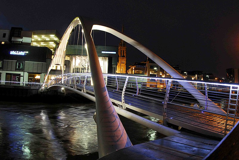
De lacey Bridge
-- Road links and infrastructure
Drogheda is located close to the M1 (E1 Euro Route 1) (main Dublin – Belfast motorway). The Boyne River Bridge carries traffic from the M1, across the River Boyne, 3 km west of the town. It was opened on 9 June 2003 and is the longest cable-stayed bridge in Ireland. The town's postcode, or eircode, is A92.
-- Railway
Drogheda acquired rail links to Dublin in 1844, Navan in 1850 and Belfast in 1852. Passenger services between Drogheda and Navan were ended in 1958, however the line remains open for freight (Tara Mines/Platin Cement) traffic. In 1966 Drogheda station was renamed "MacBride". Drogheda railway station opened on 25 May 1844.
The station has direct trains on the Enterprise northbound to Dundalk, Newry, Portadown, Lisburn and Belfast Central, and southbound to Dublin Connolly.
A wide variety of Iarnród Éireann commuter services connect southbound to Balbriggan, Malahide, Howth Junction, Dublin Connolly, Tara Street, Dublin Pearse, Grand Canal Dock, Dún Laoghaire, Bray, Greystones, Wicklow, Rathdrum and Arklow.
-- Bus transport
Drogheda's bus station is located on Donore Road. It replaces an earlier facility on the Bull Ring. Past Bus Éireann routes included the 184 to Garristown and 185 to Bellewstown but these were discontinued a few years ago.
III.Economy
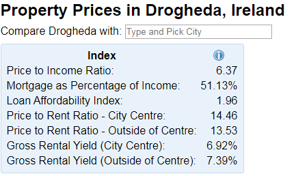
Reference: https://www.numbeo.com/property-investment/in/Drogheda-Ireland
IV.Industrial Characterisitics
Drogheda has a growing industrial base with several international companies based in the town. Local employers include the Boyne Valley Group (food producers), Coca-Cola International Services, State Street International Services, Natures Best (a food processor employing 300 people),[citation needed], Yapstone Inc, the Drogheda Port Company (the oldest indigenous employer since 1790), Glanbia, Flogas, and CRH plc.[citation needed]
Drogheda also has a history of brewing and distilling, with companies Jameson Whiskey, Coca-Cola, Guinness, Jack Daniel's all having previously produced (or are still producing) their products in or near the town. These include the Boann distillery and brewery, Slane Whiskey (a Jack Daniel's-owned company), Listoke House, Dan Kellys (cider), and Jack Codys (craft beers and stouts).[citation needed] The town formerly distilled Prestons whiskey, a Jameson Whiskey brand; Carines Beer, founded locally and sold to Guinness; and Coca-Cola concentrate, which has since moved to Ballina, County Mayo.
V.Attractions
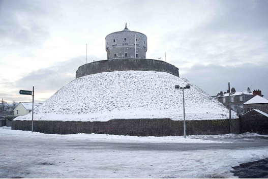
Drogheda is an ancient town that has a growing tourism industry. It has a UNESCO World Heritage site, Newgrange, located 8 kilometres (5.0 mi) to the west of the town centre. Other tourist sites in the area include:
-- Millmount Fort and museum
-- Saint Laurence Gate barbican gate c. 1300s
Saint Laurence's Gate
Former names: Great East Gate
Type: Barbican
Address: St. Laurence Street
Town or city: Drogheda
Country: Ireland
Completed: c1280
Owner: Office of Public Works
Website: St.Laurence Gate
Saint Laurence's Gate is a barbican which was built in the 13th century as part of the walled fortifications of the medieval town of Drogheda in Ireland. It is a barbican or defended fore-work which stood directly outside the original gate of which no surface trace survives. It has been described as one of the finest of its kind, and is designated as a national monument. The original names for Laurence Street and Saint Laurence Gate were Great East Street and Great East Gate, respectively. In the 14th century, the street and gate were renamed because they led to the hospital of Saint Laurence, which stood close to the Cord church.
-- Boyne Viaduct
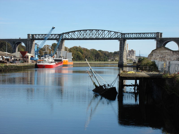
Boyne Viaduct
Irish: Tarbhealach na Bóinne
Coordinates 53°43′00″N 6°20′15″WCoordinates: 53°43′00″N 6°20′15″W
Carries Belfast-Dublin railway line
Crosses River Boyne
Locale Drogheda
Maintained by Iarnród Éireann
Characteristics
Design Stone arch & Iron truss
History
Designer John Benjamin Macneill
Construction start 1851
Construction end 1855
The Boyne Viaduct (Irish: Tarbhealach na Bóinne), a 30-metre-high (98 ft) railway bridge, or viaduct, that crosses the River Boyne in Drogheda, carrying the main Dublin–Belfast railway line.
Battle of the Boyne between James II and William III, 11 July 1690, Jan van Huchtenburg
The Battle of the Boyne (Irish: Cath na Bóinne IPA: was a battle in 1690 between the forces of the deposed King James II of England and Ireland, VII of Scotland, versus those of King William III who, with his wife Queen Mary II (his cousin and James's daughter), had acceded to the Crowns of England and Scotland in 1689. The battle took place across the River Boyne close to the town of Drogheda in the Kingdom of Ireland, modern-day Republic of Ireland, and resulted in a victory for William. This turned the tide in James's failed attempt to regain the British crown and ultimately aided in ensuring the continued Protestant ascendancy in Ireland.
The battle took place on 1 July 1690 O.S. William's forces defeated James's army, which consisted mostly of raw recruits. Although the Williamite War in Ireland continued until October 1691, James fled to France after the Boyne, never to return.
-- Eamonn Ceannt's school (formerly St Joseph's CBS now operates as Scholars Hotel)
-- Beaulieu House and gardens
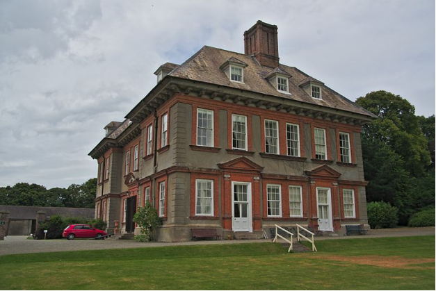
Beaulieu House and Gardens is an estate in Drogheda, Co. Louth, Republic of Ireland. It was thought to be built in the 1660s, although later research seems to suggest it was built around 1715, and it includes a terraced walled garden. It is located 2 miles (3.2 km) east of Drogheda less than half a mile from the estuary of the River Boyne.
-- Mellifont Abbey
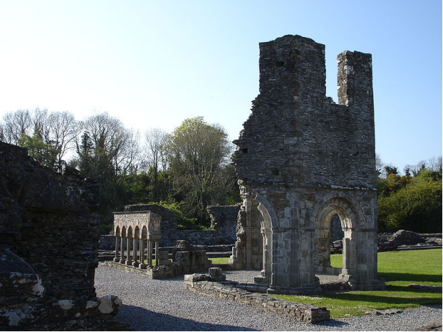
Mellifont Abbey (Irish: An Mhainistir Mhór, literally 'the Big Monastery'), was a Cistercian abbey located close to Drogheda in County Louth, Ireland. It was the first abbey of the order to be built in Ireland. In 1152, it hosted the Synod of Kells-Mellifont. After its dissolution in 1539 the abbey became a private manor house. This saw the signing of the Treaty of Mellifont in 1603 and served as William of Orange's headquarters in 1690 during the Battle of the Boyne.
Today, the ruined abbey is a National monument of Ireland and accessible to the public. The English language name for the monastery, 'Mellifont', comes from the Latin phrase Melli-fons, meaning 'Font of Honey'.
-- Townley Hall nature trail and woods
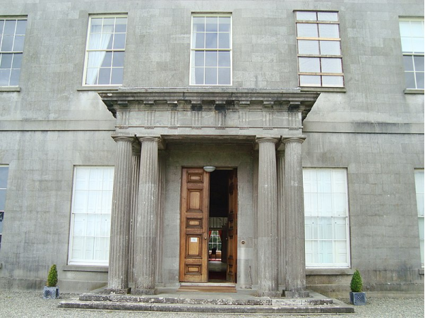
Townley Hall is a Georgian country house which stands in parkland at Tullyallen some 5 km west of Drogheda, County Louth in the Republic of Ireland. It was designed by Irish architect Francis Johnston for the Townley Balfour family and built between 1794 and 1798.
Built in 1799, Townley Hall is regarded as a masterpiece in the classical style of Francis Johnston, the foremost Irish architect of his day. It sits in quiet seclusion of private grounds, approached by a long wooded avenue. Commissioned as a private home for the Townley Balfour family, it was designed to impress on the visitor not only the wealth and sophistication of a substantial landlord, but the craftsmanship available in the local area. Having undergone only minor alterations in over two centuries, this house is one of Ireland’s hidden architectural gems.
The house is 27 metres (90 feet) square, built in local stone with simple neoclassical lines, broken only by a Doric portico. The interior is dominated by a spiral staircase in a domed rotunda. The building replaced a previous house which once stood some 100 metres (300 feet) to the north of the present building
-- St. Peter's Roman Catholic Church, which houses a shrine of Oliver Plunkett
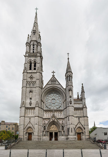
St. Peter's Roman Catholic Church is located on West Street, Drogheda, County Louth, Ireland. Designed by J. O'Neill and W.H. Byrne and built in the French Gothic style of local limestone ashlar in 1884. The church is famous for its tall west gable, rose window and for containing the national shrine of St. Oliver Plunkett.
-- St Peter's Church of Ireland church, on Peter's Hill
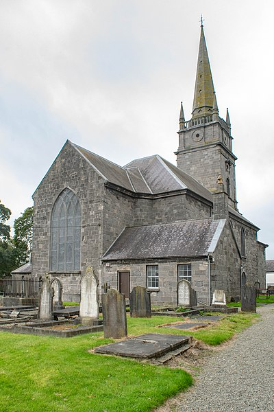
St. Peter's Church of Ireland is an Anglican (Episcopalian) church located in Drogheda, Ireland, in the Diocese of Armagh. Designed in the Georgian style, St. Peter's starkly contrast starkly with the Neo-Gothic Roman Catholic church of the same name, located in the town centre.
VI.History
Hinterland
The town is situated in an area which contains a number of archaeological monuments dating from the Neolithic period onwards, of which the large passage tombs of Newgrange, Knowth, and Dowth are probably the best known. The density of archaeological sites of the prehistoric and early Christian periods uncovered in the course of ongoing developments, (including during construction of the Northern Motorway or 'Drogheda Bypass'), have shown that the hinterland of Drogheda has been a settled landscape for millennia.
Town beginnings
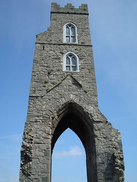
St Mary Magdalene Friary.
Despite local tradition linking Millmount to Amergin Glúingel, in his 1978 study of the history and archaeology of the town John Bradley stated that "neither the documentary nor the archaeological evidence indicates that there was any settlement at the town prior to the coming of the Normans". The results of a number of often large-scale excavations carried out within the area of the medieval town appear to confirm this statement.
One of the earliest structures in the town is the motte-and-bailey castle, now known as Millmount Fort, which overlooks the town from a bluff on the south bank of the Boyne and which was probably erected by the Norman Lord of Meath, Hugh de Lacy sometime before 1186. The wall on the east side of Rosemary Lane, a back-lane which runs from St. Laurence Street towards the Augustinian Church is the oldest stone structure in Drogheda. It was completed in 1234 as the west wall of the first castle guarding access to the northern crossing point of the Boyne. The earliest known town charter is that granted to Drogheda-in-Meath by Walter de Lacy in 1194. In the 1600s, the name of the town was also spelled "Tredagh" in keeping with the common pronunciation, as documented by Gerard Boate in his work Irelands' Natural History. In c. 1655 it was spelled "Droghedagh" on a map by William Farriland.
Drogheda was an important walled town in the English Pale in the medieval period. It frequently hosted meetings of the Irish Parliament at that time. According to R.J. Mitchell in John Tiptoft, Earl of Worcester, in a spill-over from the War of the Roses the Earl of Desmond and his two youngest sons (still children) were executed there on Valentine's Day 1468 on orders of the Earl of Worcester, the Lord Deputy of Ireland. It later came to light (for example in Robert Fabyan's The New Chronicles of England and France), that Elizabeth Woodville, the queen consort, was implicated in the orders given. The parliament was moved to the town in 1494 and passed Poynings' Law, the most significant legislation in Irish history, a year later. This effectively subordinated the Irish Parliament's legislative powers to the King and his English Council.
Later events
The town was besieged twice during the Irish Confederate Wars.
On the second occasion an assault was made on the town from the south, the tall walls breached, and the town was taken by Oliver Cromwell on 11 September 1649, as part of the Cromwellian conquest of Ireland and it was the site of a massacre of the Royalist defenders. In his own words after the siege of Drogheda, "When they submitted, their officers were knocked on the head, and every tenth man of the soldiers killed and the rest shipped to Barbados."
The Earldom of Drogheda was created in the Peerage of Ireland in 1661.
The Battle of the Boyne, 1690, occurred some 6 km (3.7 mi) west of the town, on the banks of the River Boyne, at Oldbridge.
In 1790, Drogheda Harbour Commissioners were established. They remained in place until 1997 when the Drogheda Port Company a commercial enterprise replaced them.
In 1825, the Drogheda Steam Packet Company was formed in the town, providing shipping services to Liverpool.
In 1837, the population of Drogheda area was 17,365 people, of whom 15,138 lived in the town.
Town arms
Drogheda's coat of arms features St. Laurence's Gate with three lions, and a ship emerging from either side of the barbican. The town's motto Deus praesidium, mercatura decus translates as "God our strength, merchandise our glory".
The star and crescent emblem in the crest of the coat of arms is mentioned as part of the mayor's seal by D'Alton (1844). In 2010, Irish president Mary McAleese, in a speech delivered during an official visit to Turkey, stated that the star and crescent had been added in the aftermath of the Great Famine as gratitude for food supplies donated by the Ottoman Sultan, which had arrived at Drogheda by ship. Irish press quickly pointed out the story was a myth, with a local historian calling it 'nothing short of sheer nonsense'. However, later evidence, including a letter displayed at the office of the European Commission, confirms that Turkey came to the aid of the Irish during the Famine.
21st century
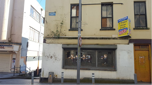
derelict building in the Westgate area of Drogheda town
Two decades into the 21st century some of the historic core of Drogheda town has suffered urban decline. Some of the buildings have been derelict for some years and are in danger of collapse. There was a 2006 traffic plan for pedestrianisation of West Street. It was rejected at a vote of the elected councillors. They had come under pressure from traders in the area concerned about a potential further decline in customer footfall. But the issue has come up for debate again. When asked, Drogheda residents point out that a combination of expensive car-parking and high commercial rates had a push-pull effect on the town's centre. Shops were forced to close and at the same time shoppers brought their business to retail parks such as the Boyne Shopping Centre on Bolton Street. A substantial root-and-branch approach to renewal of the locality was proposed in “Westgate Vision: A Townscape Recovery Guide”. The Westgate area of Drogheda is to be subject to a 10-year regeneration by Louth County Council.
VII.Other information
Arts and entertainment
Music
Drogheda has hosted the national traditional music festival, Fleadh Cheoil na hÉireann, in 2018 and again in 2019.
Drogheda is home to two brass bands: Drogheda Brass Band and Lourdes Brass Band. Both bands have been National Brass Band Champions of Ireland and Northern Ireland.[citation needed] The town is known nationally for its choral tradition which goes back many years.
Drogheda hosted the international summer Samba festival in which Samba bands from around the world came to the town for three days of drumming and parades.
The composer and member of Aosdána, Michael Holohan, has lived in Drogheda since 1983. His compositions have been performed and broadcast both at home and internationally. Career highlights in Drogheda include Cromwell 1994, 'Drogheda 800' (RTECO, Lourdes Church); The Mass of Fire 1995 , 'Augustinian 700' (RTÉ TV live broadcast); No Sanctuary 1997 with Nobel Laureate and poet Seamus Heaney (Augustinian Church); Remembrance Sunday Service and Drogheda Unification 600 (RTE TV live broadcast, St Peter's Church of Ireland) and two major concerts with The Boyne Valley Chamber Orchestra at Fleadh Cheoil na hÉireann in 2018 and 2019.
Visual Arts
October 2006 saw the opening of The Highlanes Gallery, the town's first dedicated Municipal Art Gallery. Its location is the former Franciscan Church and Friary on St.Laurence Street. The gallery houses Drogheda's important municipal art collection, which dates from the 17th century, as well as visiting exhibitions in a venue which meets key international museum and gallery standards. Drogheda's most famous visual artist was the abstract expressionist painter Nano Reid (1900–1981). There are many highly regarded visual artists working in Drogheda at the present time. Too many to list they include; Richard Moore, Raphael Hynes, Mary Mc Donnell, Vivienne Byrne, John Moloney, Maureen Finn, Jackie Hudson Lalor, Patrick Dillon, Nuala Early, Roger Hudson and Ronan Halpin.
Politics and government
Drogheda Borough Council is an elected local government body which is mandated under the Local Government Act 2001 to provide civic leadership and a forum for the democratic representation of the community. Responsibilities include amenity support, operation of the Litter Act, contribution to tourism development, event licensing, arts support, etc. The Borough Council executive comprises twelve elected Councillors, headed by the mayor. The mayor, elected in June 2019 for the period 2019–2020, was Paul Bell (Labour).
For local elections to Louth County Council, the town forms part of two local electoral areas – Drogheda East and Drogheda West. This includes both the urban Drogheda area and surrounding rural areas.[citation needed]
For the purposes of elections to Dáil Éireann, the town is part of the Louth constituency which returns five TDs.
Media
The local newspapers are the Drogheda Independent and Drogheda Leader, known locally as The D.I. and The Leader. Both newspapers are published every Wednesday. The headquarters of The Drogheda Independent are on Shop Street and The Drogheda Leader's offices are on Laurence Street.
The local radio station is LMFM, broadcasting on 95.8 FM. The headquarters of LMFM are on Marley's Lane on the south side of the town.
Hospitals and health care
Drogheda is a regional centre for medical care. Its main hospital is Our Lady of Lourdes Hospital, a public hospital located in the town. and is part of the Louth Meath Hospital Group. Facilities include a 24-hour emergency department for the populations of County Louth, County Meath and the North-East of Ireland. The hospital provides 340 beds, of which 30 are reserved for acute day cases.
The Cottage Hospital on Scarlet Street is a former maternity hospital, which subsequently became a Geriatric Unit for a number of years and is now a long-stay residential unit.
Sport
The town's association football (soccer) team, Drogheda United FC, won the FAI Cup for the first time in 2005. The club also won the Setanta Cup in 2006, and the League of Ireland for the first time in 2007.
In rugby union, the local Boyne RFC team was formed in 1997 from the amalgamation of Delvin RFC and Drogheda RFC. As of 2010, the men's 1st XV team were playing in the Leinster J1 1st division. Drogheda is also home to a number of rugby-playing schools.
There are five Gaelic Athletic Association clubs in Drogheda: Newtown Blues GFC, Wolfe Tones GFC, O'Raghallaigh's GFC, Oliver Plunket's GFC, and St. Nicholas's GFC.
VIII.Contact information
Mayor: Mr. Paul Bell
Louth County Council
Address: County Hall Millennium Centre, Dundalk, A91 KFW6
Telephone: 1890 202 303
E: info@louthcoco.ie
eolas@contaelu.ie
Website: https://www.louthcoco.ie
