Grindavíkurbær 作者: 来源: 发布时间:2021-06-15
一、所属省或是州,具体位置,人口,面积
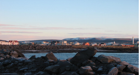
Grindavík is a fishing town on the Southern Peninsula of Iceland not far from the tuya Þorbjörn. As of 2020 it has a population of 3,300 people (18th largest), and a total area of 433.6 square kilometers (43rd largest).
It is one of the few cities with a harbour at this coast. Most of the inhabitants work in the fishing industry. The Blue Lagoon, Grindavík's premiere attraction, is located 5 kilometres (3 mi) from the town center.
二、自然地理
1.地理条件
The scenic nature surrounding Grindavík includes more than just the blue-water hot-spring which has become so popular, and some are positively breathtaking. The imposing and awe inspiring scenic landscape with enormous hardened lava cliffs loom over paths across the vast expanse of lava fields, but there is also delicate beauty, silky soft moss appears to embrace the violently jagged lava creating in some areas a fantastically surreal “pillow-like” ground but in other places, the threatening form of razor sharp hardened lava with cracks, craters and miniature canyons provide a full scale display of the movements of the tectonic plates. The absolute power, albeit dormant, of mother-earth is rarely as graphically depicted as in the chaotically elaborate lava fields. The ocean pounds the shoreline seamlessly and thereby takes on an important role in shaping the land. It’s no wonder that a number of prominent artists have sought inspiration – many successfully – from the raw nature in this area.
Þorbjörn, a lone hill peak to the north of Grindavík, stands about 250 meters tall and is easily accessible by foot. The stroll is quite rewarding – offering to those who scale Þorbjörn a view of almost the entire Reykjanes peninsula. The Ravine at Svartsengi (called “Gjáin” in Icelandic, which means simply “the ravine”) takes advantage of the latest technology to create a multimedia show which displays the geological history of earth and Iceland, the Reykjanes peninsula and Svartsengi in particular. A visit to Ravine heightens the experience of exploring the area’s nature as the newfound learning allows you to look at it from a new perspective.
East of Grindavík, Krýsuvík, Selatangar, Festarfjall and seemingly endless lava fields are among places to see. To the south, the Atlantic Ocean battles the island endlessly and to the west from Grindavík lays Reykjanes and the Reykjanes light house, the Gunnuhver (the “Gunna geyser”), Brimketill, Eldvörp and a multitude of other interesting natural phenomena.
http://www.grindavik.is/english
2.交通情况
Grindavík is only a 15 minutes drive from Keflavík Airport and 10 minutes from the Blue lagoon. Also you can reach the capital Reykjavik within 40 minutes driving.
https://icelandictimes.com/search_page/grindavikurbaer-2/
三、经济发展和规模
The municipality's operating income during the year amounted to ISK 3,642 million. kr. according to the annual accounts for Parts A and B, of which Part A operating income ISK 3,312 million kr.
The tax rate was 13.99% but the statutory maximum in 2019 was 14.52%. The Class A property tax rate was 0.315%, with a statutory maximum of 0.5%.
The Class B tax rate amounted to 1.32%, which is the statutory rate. In category C, the tax rate was 1.45% but the statutory maximum is 1.32%, but local governments are authorized to increase the tax rate in categories A and C by up to 25%.
The municipality's operating result according to the annual accounts of Parts A and B was positive by ISK 496.0 million. kr. and in Part A about 443.8 million kr. The municipality's equity at the end of 2019 amounted to ISK 8,901.7 million. kr. according to the balance sheet, but equity A share amounted to ISK 8,763.6 million. kr.
http://www.grindavik.is/v/35
四、产业特点/重点项目
The majority of the inhabitants live from fishing, processing and trading. There are very good fishing grounds right in front of Grindavík on the shelf of the Reykjanes ridge. As a result, the now expanded port is of great importance for the country's economy. the largest fishing and fish processing companies there are Þorbjörn, Vísir and Stakkavík. Grindavík alone provides more than 40% of Iceland’s salt fish production with one of the most active harbours in the country.
The fish caught off the coast - mostly herring, capelin, sea wolf and cod - were dried and preserved in this way until the end of the 19th century. However, since the end of the 19th century it has been placed in salt and frozen since the second half of the 20th century.
There is also the Grindavík Salt Fish Museum, which shows fishing and processing methods.
In the meantime, more and more people are commuting to Reykjavík and property prices are rising accordingly.
Besides fishing Grindavik is a large tourist destination due to its unique landscape and access to Iceland’s most famous geothermal pool called the Blue Lagoon. The lagoon recorded 1.3 million visitors in 2017, up from 919,000 visitors in 2015. The company had a revenue of €102 million and a profit of €31 million in 2017. It has over 600 employees. The entry fee is from $64.
https://icelandictimes.com/search_page/grindavikurbaer-2/
五、风景名胜,景点( attractions)
1. Blue Lagoon
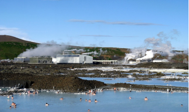
The Blue Lagoon is a geothermal spa in southwestern Iceland. The spa is located in a lava field near Grindavík and in front of Mount Þorbjörn on Reykjanes Peninsula, in a location favourable for geothermal power, and is supplied by water used in the nearby Svartsengi geothermal power station. The Blue Lagoon is approximately 20 km (12 mi) from Keflavík International Airport, and is one of the most visited attractions in Iceland.
The lagoon is man-made. The water is a byproduct from the nearby geothermal power plant Svartsengi where superheated water is vented from the ground near a lava flow and used to run turbines that generate electricity. After going through the turbines, the steam and hot water passes through a heat exchanger to provide heat for a municipal water heating system. Then the water is fed into the lagoon.
The rich mineral content is provided by the underground geological layers and pushed up to the surface by the hot water used by the plant. Because of its mineral concentration, water cannot be recycled and must be disposed of in the nearby landscape, a permeable lava field that varies in thickness from 50 cm (20 in) to 1 m (3.3 ft). After the minerals have formed a deposit, the water reinfiltrates the ground, but the deposits render the ground impermeable over time, so the plant needs to continuously dig new ponds in the nearby lava field.
2. The Icelandic Saltfish Museum
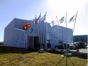
In a magnificent 650 sqm exhibition space, a staged journey through time is staged, the history of salted fish processing from the beginning is traced in chronological order to the days when mechanical technology unleashed the human hand. A traveler gets the feeling that he is in a small fishing village from 1930. The designer of the exhibition is Björn G. Björnsson.
Saltfisksetur Íslands was built in 2003. The house is 1250 sqm and is divided into 650 sqm exhibition space, 320 sqm art exhibition hall and 280 sqm reception hall. The Saltfisk Center has a Grindavík information center as well as a souvenir shop and a cafeteria.
http://www.grindavik.is/kvikan/saltfisksetur
3. Eldvörp Row of Craters
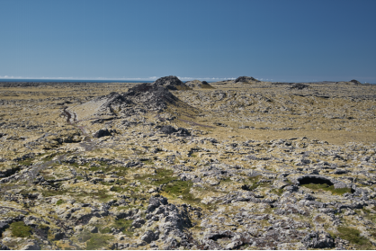
This is a 10 km long crater row accessible on foot, by bike and by car on a dirt track from the Blue Lagoon to Grindavik link road. There's a borehole here but natural steam also escapes at various points along the crater row. The lava is rugged and peppered with holes and caves and clad in thick moss in places. It has a wild and windswept feel to it. There is a way-marked walking trail through the lava and the Reykjavegur Trail passes by here too. It's not as striking as the volcanic landscapes of Lake Mývatn, Landmannalaugar, Askja or Laki but it's impressive enough and importantly is a vital component of the geological showcase of Reykjanes. The site is signposted from the Grindavik-Blue Lagoon link road, but as it's not well known, it's unlikely that the uninformed would bother to check it out.
http://www.grindavik.is/english
六、历史文化
1.历史
Landnáma or The Book of Settlements mentions that around 934 two Viking settlers, Molda-Gnúpur Hrólfsson and Þórir Haustmyrkur Vígbjóðsson, arrived in the Reykjanes area. Þórir settled in Selvogur and Krísuvík and Molda-Gnúpur in Grindavík.
The sons of Moldar-Gnúpur established three settlements; Þórkötlustaðahverfi, Járngerðarstaðarhverfi and Staðarhverfi. The modern version of Grindavik is situated mainly in what was Járngerðarstaðarhverfi.
In June 1627 Grindavik was raided by Barbary Pirates in an event known as the Turkish Abductions. Twelve Icelanders and three Danes, along with two vessels were taken, and with captives taken from other Icelandic settlements, transported into slavery in Algiers.
The origins of the municipality can be traced to Einar Einarsson's decision to move there to build and run a shop in 1897. During that time the population was only around 360. Fishing had for centuries been a crucial element in the survival of Grindavik's population, but fishing trips were often dangerous. Men were frequently lost at sea and the catch not always stable. However, when a safer access point to land was created at Hópið in 1939, fishing conditions changed dramatically. From 1950 serious development in the fishing industry had begun to take place. Grindavik was declared a municipality in 1974.
In Grindavík, there has long been a strong rescue and accident prevention work, where the Þorbjörn Rescue Squad is located. The pioneer of accident prevention in Iceland, Sir Oddur V. Gíslason, was a priest at Staður in Grindavík in the years 1878-1894, but in parallel with his priestly work in Grindavík he rowed for fish and then began a great fight for the safety of seafarers. The Grindvík rescue ship is named after Oddur V. Gíslason. The rescue team Þorbjörn was the first rescue team in Iceland to use so-called airline equipment for rescue, but that was when the French trawler Cap Fagnet ran aground on March 24, 1931.
2. 文化体育
Grindavík was first and foremost a restaurant, the fishing industry has for a long time been the main industry of the Grindvík people who built boats from driftwood until 1500. In particular, they rowed to fish to get sweeteners. The procedures, customs and practices associated with the fishing were similar to those that had prevailed for centuries, and on land most of them were in the same situation century after century. This was the case until the turn of the century in 1900, when the population was 357. Then the population of Grindavík began to increase, new houses rose from the ground, where no one had stood before, villages began to form, paved roads were laid to Grindavík, the people began to form associations and organizations to ease the struggle for survival and the conflict with the forces of nature. Diligent parties embarked on projects that were crucial for the development of the community, the economy picked up, the population increased even more, even more houses were built and various kinds of modern conveniences became a matter of course. Now a beautiful town has been erected in Grindavík that is noticed.
Grindavíkurbær's coat of arms was introduced in 1986 and is designed by Kristín Þorkelsdóttir. According to the decision of the Grindavík town council, Kristín's Advertising Agency (AUK) was given the task of drawing up a proposal for a coat of arms for Grindavík.
A committee was elected by the town council to work with the agency on this proposal. The committee consisted of Eiríkur Alexanderson, Margrét Gísladóttir and Ólína Ragnarsdóttir.
The committee held several meetings with Kristín Þorkelsdóttir and received several proposals for coats of arms for discussion. The committee agreed to propose that the Grindavík coat of arms be a black goat with yellow horns and red hooves on a blue and white background.
The report states that the idea for the logo was created by the staff AUK when reading a chapter about Grindavík in the book Landið þinn, which says, among other things:
http://www.grindavik.is/v/54
七、其他信息
Naval Radio Transmitter Facility Grindavik
Near Grindavík, the United States Navy operates Naval Radio Transmitter Facility Grindavik. It uses several antennas, including two guyed masts.
NRTF Grindavik originally had two towers for its longwave service – the west tower with a height of 243.8 metres (800 ft) and the east tower with a height of 182.9 metres (600 ft) – which were, when built, the tallest man-made objects in Iceland. In 1983, the east tower was replaced by a new tower of the same height. The west tower was replaced by a new 304.8-metre (1,000 ft) guyed mast and 2,500-square-foot (230 m2) helix house, now the second tallest structure in Iceland.
The N62 Division is divided into three subdivision: N62A, Antenna Maintenance; N62B, longwave equipment and ISABPS Maintenance; and N62C, shortwave equipment and Ancillary Equipment Maintenance.
In November 2019 the installation formally had a Director appointed to head it, as U.S. Naval Computer and Telecommunications Area Masters Station Atlantic Detachment Grindavik, Iceland (NCTAMS LANT DET GRINDAVIK IC)
八、联系方式
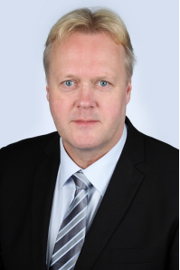
Mayor: Fannar Jónasson
Telephone: 420 1100
Email: fannar@grindavik.is
http://www.grindavik.is/
