Hvalfjarðarsveit 作者: 来源: 发布时间:2021-09-30
一、所属省或是州,具体位置,人口,面积
Hvalfjarðarsveit is a municipality in Vesturland in Northwest Iceland. The municipality derives its name from the fjord Hvalfjörður, which forms its southern border. It has a total population of 625 people (45th largest in Iceland), and a total area of 493.8 square kilometers (38th largest in Iceland).
The municipality formed on 1 June 2006, by the union of the former municipalities of Hvalfjarðarstrandarhreppur, Innri-Akraneshreppur, Leirár- og Melahreppur and Skilmannahreppur.
二、自然地理
1.地理条件
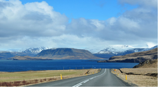
The shores of Hvalfjörður, Faxaflói and Borgarfjörður form the region's southern and western borders. Hvalfjarðarsveit additionally borders the municipalities of Kjósarhreppur in the south, Akranes in the west, as well as Borgarbyggð and Skorradalshreppur in the north, and Bláskógabyggð in the highlands to the east.
The largest settlement in the municipality is Melahverfi with a population of 111 in 2016.
Prominent mountains in Hvalfjarðarsveit (from west to east) include Akrafjall, Hafnarfjall, Skarðsheiði and Botnssúlur. Notable lakes (from west to east) include Lake Eiði, Hólmavatn, Eyrarvatn, Glammastaðavatn, Geitabergsvatn and Hvalvatn. Iceland's tallest waterfall, Glymur, forms part of the river Botnsá that runs from Hvalvatn into the eastern bottom of Hvalfjörður.
Some 30 km of the Ring Road pass through Hvalfjarðarsveit, between the Hvalfjörður Tunnel in the south and Borgarnes in the north.
Population statistics of the municipality separated by communities:
The former rural community of Hvalfjarðarströnd had 147 inhabitants (2005). The municipality was north of Hvalfjörður and rises in Skarðsheiði to 1,041 meters. The place of the church was Saurbær.
The former rural community Skilmannahreppur had 214 inhabitants (2005). The parish was on the north side of the Akranes Peninsula. Located in the immediate catchment area of the city of Akranes, the municipality of Skilmannahreppur recorded a population increase of 71% from 1997 to 2005.
The former rural community of Innri-Akranes (Isl. Innri-Akraneshreppur) had 113 inhabitants (2005). The parish was on the south side of the Akranes Peninsula. The church place is Innrihólmur.
The former rural community Leirá og Melar (Isl. Leirár- og Melahreppur) had 129 inhabitants (2005). The municipality was on the south side of Borgarfjörður. The place of the church was Leirá.
2.交通情况
The main roads are the Hringvegur in the west of the municipality and the Hvalfjarðarvegur S47, which goes around the Hvalfjörður. The community is connected to Mosfellsbær and Reykjavík via the long Hvalfjarðargöng tunnel that runs below Hvalfjörður.
Nowadays the journey through the Hvalfjarðargöng tunnel under the fjord is significantly shortened. The tunnel was developed and built by Icelandic companies. It has two lanes and goes down to a depth of 165 m, so it is about 130 m below the seabed.
三、经济发展和规模
Hvalfjarðarsveitar's annual accounts are prepared in accordance with the Local Government Act, the Annual Accounts Act, the Regulation on accounting, budgets and annual accounts of municipalities.
The municipality's operating income for the year amounted to ISK 1,056 million. kr. according to the income statement for A and Ð parts, but there of operating income in Part A amounted to ISK 1,048 million. kr. The tax rate was 13.69% but its statutory maximum is 14.52%. Real estate tax rate in A-category was 0.44% but its statutory maximum is 0.5%, in category B the tax rate was 1.32% which is statutory and in category C, the tax rate was 1.65%, but its statutory maximum is 1.32%, in addition to the local authorities' authorization to to increase the tax rate in Classes A and C by up to 25%.
Wages and salary-related expenses during the year amounted to a total of ISK 441.7 million. kr. The operating result of the municipality according to the annual accounts of Parts A and B was positive by ISK 906.6 million. kr. The operating result for Part A was positive by ISK 906.5 million. kr. according to the income statement. The municipality's total assets amounted to ISK 3,310.2 million. kr. and total liabilities ISK 182.7 million. kr. The municipality's equity in year-end amounted to ISK 3,127.5 million. kr. according to the balance sheet, but the equity of Part A amounted to ISK 3,106.9 million. kr.
https://www.hvalfjardarsveit.is/is/stjornsysla/fjarmal-og-tolfraedi/arsreikningar
四、产业特点重点项目
Although the region is mostly rural and scarcely populated, Grundartangi industrial area contains a significant part of Iceland's heavy industry, and one of the country's largest ports. The port of Grundartangi opened in 1978, is operated by Faxaflóahafnir and owned by some of the neighbouring municipalities.
A ferrosilicon plant began operations in 1979 and is now the world's second largest producer, operated by Elkem, a subsidiary of China National Bluestar Group. An aluminium plant began operations in 1998, operated by Norðurál, a subsidiary of Century Aluminum. Silicor Materials is currently planning to construct a solar silicon plant at Grundartangi.
Pollution in the region caused by sulphur dioxide and fluorine emissions from the industrial area is controversial.
五、风景名胜,景点( attractions)
1. Glymur Waterfall
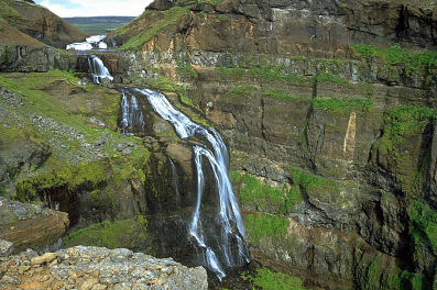
Glymur is the second-highest waterfall in Iceland, with a cascade of 198 m. It was long regarded as the tallest until being surpassed by Morsárfoss, a newly measured waterfall near Morsárjökull in 2011.
It is situated at the rear end of the Hvalfjörður. Since the opening of the Hvalfjörður Tunnel under this fjord, visitor numbers have dropped.
The river Botnsá runs from the Hvalvatn lake and after a short distance the water falls down alongside the Hvalfell mountain into a steep canyon. The waterfall can be accessed from a parking area at the end of the road. Hikers can view the waterfall from marked paths on the east side of the river Botnsá.
To get to the carpark of Glymur, from which you can hike to it, takes about forty five minutes if driving from Reykjavík.
You first will head north on Route 1, before turning right on Route 47, before Hvalfjörður tunnel. This road will take you along the edge of the fjord itself, providing stunning views of the coast, mountains, flora and more smaller waterfalls.
From the carpark, the hike takes approximately three and a half hours to do in total. It is largely through nature, without any paved roads, and at some points can be a little challenging; the most used route, for example, involves wading across a river with the help of a rope, passing through a cave, and walking along a narrow mountainside path.
https://guidetoiceland.is/travel-iceland/drive/glymur
2. Geirshólmur Island
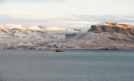
Geirshólmur is a small island in the heart of Hvalfjörður, opposite Hvalstöðin. It is also called Geirsholmi and at times hard Holm, but that is a misnomer.
The story goes that in Geirshólmur, the so-called Hólmver started, the robber team led by Harður Grímkelsson and there were well over two hundred people in the party, according to Harðar saga and Hólmveri. It is said that Harður's wife, Helga Haraldsdóttir, who was an earl's daughter from Gautland, saved herself and their two sons, Björn 4 years old and Grímkatli 8 years old, swimming from Geirshólmur and to a land called Helgusund.
During the Age of Sturlunga, a group of followers of Sturla Sighvatsson, led by his uncle Svarthöfði Dufgusson, lived for a time in Geirshólmur and from there they plundered nearby villages. There have been speculations that these events are in fact the trigger for Hardur's story.
The tourist service at Bjarteyjarsandur nearby offers storytelling trips about Geirsholmi.
3. Innri-Hólmur
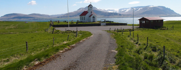
Innri-Hólmur is a large farm, church and ancient manor, close to the mouth of the Hvalfjörður tunnel. There lived the first Þormóður Bresason who studied Akranes with his brother. The brothers were Christians and it is believed that they brought priests or monks to Iceland. According to Landnáma about Innra-Hólma, a church was built there long before Christianity. About the age of the church at Innra-Hólm, it is otherwise known that there is a parish church when the tithe law is set in 1096. It is also mentioned in the church register of Bishop Páll Jónsson from around 1200 and it is mentioned that it is dedicated to the Apostle John. The church that still stands there was built in 1891 following disputes after an older church was demolished there and the parish was moved to Garður. This caused a great deal of controversy and the inhabitants of Innri-Hólmssókn built a new church which was originally made of wood, but has now been masonry. In the church you will find an altarpiece by the painter Jóhannes Kjarval.
六、历史文化
1.历史
History
In the Middle Ages and the beginning of the modern era, the fjord Hvalfjörður, which makes up the southern border of Hvalfjarðarsveit, was of great importance for south and west Iceland both as a trading center and as a fishing center.
In the 14th century z. For example, the probably most important trading center in Iceland, Maríuhöfn, was on the south bank of the fjord near Kjós. Numerous remains have been archaeologically examined. This heyday apparently lasted until the 15th century when the trading center was finally replaced by Hafnarfjörður.
This may also have had something to do with the fact that in 1402 the plague was brought into the country on a ship via Maríuhöfn.
Another well-known trading center was in the interior of the fjord at the mouth of the river Laxá í Kjós: Hvalfjarðareyri . This trading center existed in the second half of the 17th century.
20th and 21st centuries
Church and parish Saurbær à Hvalfjarðarströnd
This parish gained fame in the 17th century, when the still very popular psalmist and pastor Hallgrímur Pétursson lived and died here.
The current church from 1957 is decorated with windows by the artist Gerður Helgadóttir.
Whaling station
Inside Hvalfjörður, Iceland's most important whaling station was operated on its north side until the 1980s. The whales were processed here on land. The Trantanks are still in use today. In addition, in 2008, whales were hunted again in limited numbers, supposedly for research purposes, which are landed and dismantled here.
Allied naval bases
Hvalfjörður is the deepest fjord in Iceland. It was therefore particularly suitable for large ships such as whalers or warships. For this reason, during the Second World War, the Allies put together the northern sea convoys in the fjord, which drove from here towards the Soviet Union.
The remains of the British naval base can be seen on the south side of the fjord, those of the Americans on the north side not far from the whaling station. The oil tanks still located there are used by NATO.
2. 文化体育
Hvalfjarðarsveit participates in the operation of the Music School in Akranes, where students from the municipality can study.
The role of the Music School in Akranes is to promote a vibrant musical life, as well as to work towards increased competence, knowledge and development of individuals. Emphasis should be placed on the school serving all those who apply for music studies, regardless of age, and the school must take into account the students' diverse interests, abilities and development. The Music School in Akranes has good teaching facilities at Dalbraut 1 and offers diversity in school work.
https://www.hvalfjardarsveit.is/is/thjonusta/fraedslumal/tonlistarskoli
七、其他信息
Álfholtsskógur - a pearl in the countryside
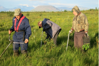
A forest grove lurks north of Akrafjall, which is partly well into its eighties. Work has been going on with varying degrees of planting since 1940.
The beginning Forestry 1 is in the years of the youth clubs, but then there was a group of young farmers in Skilmannahreppur, who were very interested in cultivating a forest, along with various other things that were on the agenda in those days, and got the land that is just west of Fannahlíð. Over time, the forestry land has been expanded and is now about 75 ha.
The older part of the forest has grown well and paths that are well marked have been laid around that part. The appearance of the forest is constantly being improved by increasing the diversity of vegetation. It is estimated that at least 200,000 plants have been planted in the forest. Most of the birch, spruce, pine and poplar have been planted, but also some reeds and larch.
Since then, there are a number of wild species in the forest that were Forestry 2planted many decades ago, as shelter plants but no longer serve their original purpose, often age poorly and are now being gauzed.
Other plant species are sparse, but still have a fun look to the forest. In total, there are between 70-80 species of trees and shrubs in the forest and different varieties of the same species.
In recent years, accessibility has been improved so that the public can enjoy enjoyable outdoor activities under the shade of the trees. Nowadays, people often talk about a lovely forest where the goal is to improve hiking trails, increase the diversity of the forest by choosing plants, draw attention to special plants with markings and draw attention to the special features of nature and views.
https://www.hvalfjardarsveit.is/is/mannlif/menningarmal/skograekt-alfholsskogur
八、联系方式
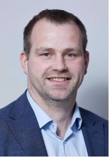
Mayor: Björgvin Helgason
Telephone: 433 8500
Email: hvalfjardarsveit@hvalfjardarsveit.is
https://www.hvalfjardarsveit.is/is/stjornsysla/nefndir
