Langanesbyggð 作者: 来源: 发布时间:2021-09-30
一、所属省或是州,具体位置,人口,面积
Langanesbyggð is a municipality in and around Langanes in the northeast corner of Iceland’s Northeastern Region. It was created by the merger of Þórshafnarhreppur and Skeggjastaðahreppur, which was approved in a referendum on April 8, 2006 and took effect on June 10, following the 2006 local elections. Among other things, Finnafjörður can be found there, but plans for a large ship harbor have been made for that fjord. The municipality has a total population of 482 (52nd largest), and a total area of 1,340.1 square kilometers (25th largest area).

二、自然地理
1.地理条件
Langanes is a large peninsula east of Þistilfjörður and north of Bakkaflói which is located in the municipality of Langanesbyggð. The peninsula stretches almost 40 km out into the sea to the northeast, wide west but narrows into a narrow cliff to the east called Fontur. Framnes is the part of Langanes called, which is south of Þórshavn, midnes out to Eiðisskarð but outside it. All the farms on the peninsula are now deserted. The headland has always been sparsely populated, the largest settlement is the fishing village of Þórshöfn on the west coast.
Low mountains and falls lie north of Langanes, 200-400 m high and the eastern part is much higher up and the lowlands are small. Gunnólfsvíkurfjall is the highest mountain, 719 m. Near the center of the headland is Eiðisskarð, which cuts the fall garden. To the north, Langanes is lowland and is the widest lowland from Sauðanes to Heiðarfjall. Útnesið is in many places rocky and barren, but on the south side it is better overgrown. The mountains are made of tuff to the southeast, but in other respects the headland is made of greywacke. The lowlands are mostly divided into bogs, rocky meadows and woods. Some rare plant species grow on Langanes, such as a braid called a rock crest.
There is a lot of bird life in Langanes, there are mainly puffins, langvía, álka, teista, fýll and rita that nest in bird cliffs. Beneath Skoruvíkurbjarg is a cliff called Stórikarl, which is the only pillar settlement in this area.
The US Army operated a radar station on Heiðarfjall 1954-68. Another NATO radar station was built on Gunnólfsvík Mountain in 1989.
2.交通情况
The capital Reykjavík is 629 kilometers away, and the closest service hub is Raufarhöfn to the northwest around 66 kilometers away.
三、经济发展和规模
Report and endorsement of the mayor and the local government.
The annual accounts of Langanesbyggð are prepared in accordance with the Local Government Act, the Act on Annual Accounts and the Regulation on Accounting, budgets and annual accounts of municipalities.
The municipality's operating income for the year amounted to ISK 939.9 million. kr. according to the annual accounts for Parts A and B, of which operating income of Part A ISK 744.9 million kr. The tax rate was 14.52%, which is the statutory maximum. The property tax rate in Class A was 0.625%, which is statutory maximum with load. In Class B, the tax rate was 1.32%, which is the statutory ratio, and in Class C the tax rate is 1.65%, which is the statutory maximum with a tax.
The operating result of Parts A and B of the municipality, according to the annual accounts of Parts A and B, was positive, amounting to ISK 54.3 million. kr., positive for Part A by ISK 55.6 million. kr. according to the income statement. The municipality's equity at the end of 2019 amounted to ISK 806.0 million. kr. according to the balance sheet for Parts A and B, but the equity of Part A amounted to ISK 545.2 million. kr.
The current Covid-19 pandemic will have a significant impact on many areas around the world, including economic. There is considerable uncertainty about the economic impact of the epidemic, e.g. due to uncertainty about how long it will last and how the effect will be after it ends. It can be expected that the impact on the municipality's operations will be considerable, e.g. due to lower tax revenues and other income, deferral of maturities and increased expenses. See further in Note 19.
https://www.langanesbyggd.is/is/stjornsysla/fjarmalaupplysingar-1/fjarmalaupplysingar
四、产业特点重点项目
The main industries are fisheries and agriculture.
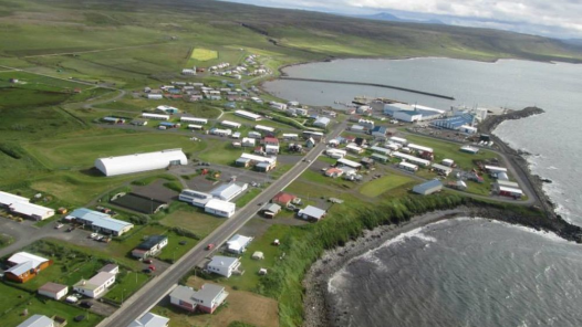
Þórshöfn (dt. Thor's port) is located on the eastern edge of Lónafjörður, an offshoot of Þistilfjörður . Þórshöfn had been a trading center since 1846, although residents did not live here permanently until 1875. At the beginning of the 20th century, herring fishing and processing gained importance. Despite the fact that the herring fishing has stopped, the inhabitants live mainly from fishing. The largest employer is the fish factory at the port, a branch of Ísfélag Vestmannaeyja.
Þórshöfn is the municipality's most important supply point; there is the only bank, post office, health center, school, kindergarten, supermarket, restaurant, swimming pool, police station, Þórshöfn airport and one of 2 petrol stations in the area.
Þórshöfn Airport (Icelandic: Þórshafnarflugvöllur) (IATA: THO, ICAO: BITN) is an airport located in Þórshöfn, a village in northeast Iceland. It is also referred to as Thorshofn Airport in many English-language sources.
Þórshöfn Airport was previously located about 4.8 km to the northeast, at 66°15′07″N 15°16′23″W, near Sauðanes, and had the ICAO code BITH (but the same IATA code – THO). It had a slightly shorter runway with a gravel surface, which has since been closed.
The airport has a very small terminal building of around 12×9 meters (39×29 ft). Domestic airports don't need security checks in Iceland, and the 19-seat Twin Otter aircraft used don't need large terminals.
The village Bakkafjörður, Langanes’ second largest settlement, was formed in the land of Hafnar and became a legal trading place in 1885 under the name Höfn but was usually called Bakkafjörður. Bakkfjörður's main industry is small boat fishing and fish processing and related services. The harbor facilities were not good for a long time, but from 1980 a new harbor was built south of the village.
Possible Large Harbour Project with German company Bremenports
In recent years, the authorities in Langanesbyggð and Vopnafjörður have been in talks with the German company Bremenports about the development of a large ship and oil port at Finnafjörður. As previously stated, the Finnafjörður project blew up the majority at the end of 2015. The issue has regularly been a point of contention in the local government and still is.
According to a recent memorandum from lawyers on the status of the project, the German company Bremenports requested that the municipalities immediately take on large and binding financial obligations. Mayor Elías Pétursson said in an interview with RÚV in February that there was no way to meet these conditions. Siggeir Stefánsson, a representative of the U-list, who has long campaigned for the project, criticized these remarks at a recent municipal council meeting. He said it was completely wrong that the company had asked for insurance or financial guarantees from the municipality and encouraged local councilors to work together.
五、风景名胜,景点( attractions)
1. Sauðanes Churchyard

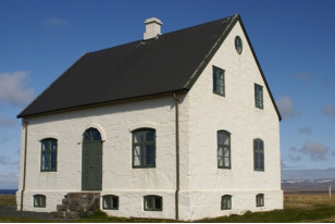
Open daily during the summer and located on Sauðanes in Langanes, 7 km from Þórshöfn. On display are various old and historical objects from Langanes and the surrounding area. The management of the house is in the hands of the Þingeying Cultural Center
The old rectory in Sauðanes has been in the custody of the National Museum of Iceland since 1989. It was in a very bad state at the time, and repairs were carried out for more than a decade. An agreement was signed in 2002 with the locals to use the house for cultural tourism and the house was formally opened in the summer of 2003.
Sr. Vigfús Sigurðsson (1811-1889) came to Sauðanes in 1869 and had previously served in Svalbarð in Þistilfjörður. He had a stone house built for him in the years 1879-81, one of the very few stone-laden houses in the country, and the work was done by the brothers Björgólfur snikkari and Sveinn múrsmiður Brynjólfssonir, who then lived in Sauðanes. A huge teak shirt, which drifted on Langanesfjörður, was used for outdoor equipment and doors. After sr. Vigfús died took sr. Arnljótur Ólafsson (1823-1904) by Sauðanes and served the bread until his death. He was nationally known for his political involvement and writing. The last building was in the old residential building in 1955, when a new rectory was taken into use, close to the old one.
https://www.northiceland.is/is/afthreying/thjonusta/saudaneshus-the-old-vicarage-langanes
2. Skálar

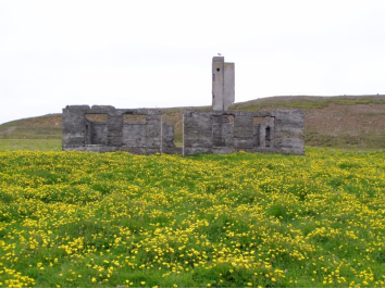
Skálar was a village in Langanes where for a time there was a thriving fishing community. There was a licensed trading place in 1912. Þorsteinn Jónsson came to Skálar in 1910 and established a fishing company with the farmer in Skálar, built a house in the summer of 1911 and established a shop. When the population was highest in the 1930s, the village was home to about 120 people, but half as many in the summer, when the seasonlasted. Rowboat owners come there with their boats and it was common for the Faroese to fish there. The Faroese sold liver ashore and bought ice cream for bait storage and sheep in the autumn from farmers. It was a difficult landing at Skálar, only a narrow strip under 10 - 12 m high vertical cliffs and all the catch had to be carried up to the bank there and very surfy. An attempt was made in 1929 to improve the landing facility, but it failed and the old landing facility became almost useless. Motorboat fishing was also increasing, but it was not possible to build motorboats at Skálar. In addition, a world crisis hit in 1931. It was also difficult to be there with the fishing industry due to transport and lack of communication, but no telephone was there and it took 2-3 days to go to the nearest telephone exchange in Þórshöfn. Now the cabins are deserted.
The population began to decrease in 1930 and around 1945 all the inhabitants moved away, but one family moved back there and lived there until 1954, when Skálar was finally deserted. You can still see the foundations of some of the houses, the old pier and various other monuments. Many of the rubble has been marked.
Some of the houses were damaged by explosions due to tornadoes that the British laid down during World War II to protect against German submarines, which is one of the reasons why the village was deserted, but the main reasons were changed fishing methods, lack of ports and lack of transport. when the village was deserted. Three tornadoes exploded on the shores of Skálar. The first tornado exploded on November 26, 1941 and the second in January 1942, but there is no record of when the third exploded. Electricity was never connected to Skálar.
3. Skoruvíkurbjarg

The hiking trail from Skoruvík to Skála runs across Langanes, but in Skoruvík was the last inhabited town on the headland. Skálar has house ruins, but there was a fishing village there at the beginning of the 20th century, which was deserted in the middle of the century, partly due to hurricane fumes that exploded on the shore and destroyed houses and the pier. There are information boards and toilets on site. From Skálar it is fun to walk to the cemetery which is on the cliff edge but it is located there because the soil was soft and deep enough.
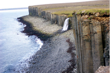
In the rock there is a puffin, langvía , álka , teista , fýll and rita and under Skoruvíkurbjarg there is a single cliff called Stórikarl and there is a pillar settlement . At Ytra-Lón there is a large barn. Skoruvík is outside the rock and the town is deserted. There is a lot of nesting and drifting. A road runs from Skoruvík east over the headland to Skálar .
https://icelandroadguide.com/items/skoruvik-2/?lang=is
六、历史文化
1.历史
The first people to be registered as living in Þórshöfn in official documents were the couple Helgi Eymundsson, a farmer and carpenter, and Hólmfríður Jónsdóttir. In 1880 they lived as homeless people in Syðribrekka, but in the years 1881-1882 they are registered as homeless in the books of the district for a home in Þórshöfn. It is not said where they stayed on the spot, but there are no other dwellings other than the so-called Skemma Jón Benjamínsson in Syðralón, which he built down by Þórshöfn in 1880 to store goods for Gránufélagið. From the brief description from around 1920 and the good durability of the house, it can be deduced that it was fairly solidly built but not stately. It is said to be a small wooden hut with an attic, clad in tar paper. It must be considered certain that Skemman was the first residential building in Þórshöfn and Helgi and Hólmfríður were the first couple to live there.
The story goes that in the middle of Langanes the hammer of the god Þór was placed and the harbor of the district was named after him, Þórshöfn. Þórshöfn stands on the east side of Lónafjörður, the innermost part of Þistilfjörður, by a small cove. There is, by nature, a good boat landing and a break for the north and northeast, which is the main sea direction in these areas. The town park is considered to be good in the landscape and a great and beautiful view to see over Þistilfjarðarflói, the countryside, the highlands, Þistilfjarðarfjöll, Langanesfjöll and Íslandshaf.
The town of Þórshöfn was built in the land of Syðra-Lón. Syðra-Lón is a land on a large scale and lands on the sea south of Langanes on the west side, from Fossá south of Þórshavn to the north or northeast in the middle of Háubakki, north of Markvatn.
Next to the sea, the land is different and in various ways, with well-vegetated swamps and meadows. Then there are sloping marshes from Fossá north of the town of Syðra-Lón and there to the north take the so-called Flaga, north to the boundaries of Sauðanes, but along it are marshes at the top, but on the sea side are heather and wood peat. There is a lot of arable land there. When the sea recedes, the land rises somewhat. There is a wide division of peat, large boulders, brook valleys with small grasses and bays with larger vegetation. The land is rather snowy and quite good for grazing in winter. Good summer pastures, at least for sheep. There is some beach grazing.
For a short time, there was a lot of haymaking on the outskirts, as place names such as Engidalur and Slátturflói show. Hafnarlækur rises in Stóraflói, but flows south through the marshes below to the sea in the town. Over it lie two roads from the village. On the sea side of Hafnarlækur is "Holtið", as it is called, a low valley between Þórshavn and Háubakki. In this wood part of the village has now become. There is also the town Syðra-Lón.
https://www.langanesbyggd.is/is/stjornsysla/frettir/saga-thorshafnar
2. 文化体育
There has always been a thriving culture in the municipality, as culture can be very broad. The Þórshafn Theater Company, the Hvöt Women's Association, the Hafliði Rescue Squad are active here, as well as various incidental events such as bridal evenings, bar-answers, þorrablót, dances, concerts and more. runs all year round.
Pier days
Every summer, the community and cultural festival Bryggjudagar is held and the third weekend in July has been established for some time. The program is different each time, but you can usually find music events, economy evenings, an outdoor market and much more. The program can be found on Kátra dagar's website on facebook and on Langanesbyggð's website as the festival draws to a close.
https://www.langanesbyggd.is/is/thjonusta/manning-og-listir
七、其他信息
Rare herbs grow on Langanes, such as lichens called rock crests. Magnificent bird life is on Langanes. Beneath Skoruvíkurbjarg is a cliff called Stórikarl. It is the largest colony in the North and also nests many other bird species such as long-tailed deer, ryegrass and vulture.
https://www.langanesbyggd.is/is/thjonusta/um-langanesbyggd-1/um-langanesbyggd/utgefid-efni
八、联系方式

Mayor: Elías Pétursson
Telephone: 468 1220
Email: langanesbyggd@langanesbyggd.is
https://www.langanesbyggd.is/is/stjornsysla/frettir/stadhaettir
