Kluczbork-Opole 作者: 来源: 发布时间:2021-07-15
Ⅰ. Population and Area
Population (2019-06-30)
• Total 23,554
• Density 1,952.3/km2 (5,056/sq mi)
Area
• Total 12.35 km2 (4.77 sq mi)
Website https://www.kluczbork.eu

Ⅱ.Natural Geography (environment and resources)
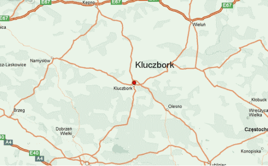
-Kluczbork is a place in south western Poland in the province of Opolskie. The County encompasses an area of 852 square kilometers and presently has a population of around 69 700 people. The domestic roads, such as No 11 Gliwice - to - Poznań and Opole - to - Łódź are intersecting on its territory, what in turn is favorable for passenger traffic and at the same time transport traffic both within the country as well as abroad (Germany and the Czech Republic). The Town of Kluczbork is also a significant railway junction with Katowice - to - Wrocław and Katowice - to -Poznań lines as well as towards Częstochowa and Opole.
-The area characteristics
-The Kluczbork County is situated in the „Śląska Lowlands by the River Stobrawa - the right tributary of the River Odra in the northern part of the Opole Province covering the south-western part of the country of the ancient Piasts' (Polish dynasty of kings) Silesia Land. Due to its situation as far as land configuration is concerned, the Kluczbork County belongs to the lowland areas. Considerable part of its area does not exceed the level of 250 m a.s.l. Thus, lowland areas are dominating in the landscape and unevenness of the land - usually de-level-ling does not exceed beyond 20 up to 40 m.
-Nature
-The Kluczbork County due to its location, natural resources, tradition and history features an agricultural and industrial character. The mosaic of forests and meadows as well as numerously occurring rivers and ponds make the area of the county various in habitats and plant gatherings abundant in protected and rare species of plants. Many of them, such as Lycopodium claratum (Latin), wild pepper, periwinkle Nymphaea alba (latin and have been numbered among the "Red list of vascular plants endangered in Poland". Numerous forests complexes are very attractive for mushroom pickers, as there is a great abundance of mushrooms here (boletus, chanterelle, Suillus (Latin), podgrzybek) as well as undergrowth (bilberries), and at the same time forests full of game, such as deers, wild boars, hares, foxes and martens. What makes up a great attractiveness for hunters. The area of the county, apart from the variety of the plant and animal world and abundance of forests are characterized by natural resources, such as Wołczyńska brine of the temperature of +43.3oC (chlorine, sodium, lime, bromine, ferruginous and boron brine) having the certificate of the Minister of Environmental Protection qualified for usage in balneology), gravel used in construction, sand, peat, pure air, good water and many green areas.
-The borders of the Kluczbork County cover the part of the Strobrawski Landscape Park as well as the area of the protected landscape "Strobrawsko-Turawskie Forests"
-Transport
-In Kluczbork the major rail line from Katowice splits into two directions – westwards to Wrocław and northwards to Poznań. It is also connected with Fosowskie.

Ⅲ.Economy

Kluczbork budget income's sources as of 2015.
-The Gmina Kluczbork has some 1800 businesses (1300 of which are located within the city's boundaries). The largest factories in Kluczbork are: Fabryka Maszyn i Urządzeń „Famak” (machinery production), PV „Prefabet - Kluczbork” S.A. (concrete materials) and Wagrem sp. z o.o. Kluczbork (weighing scale repairs).
-The part of the town of Kluczbork, around Ligota Dolna, is part of the Wałbrzych Special Economic Zone (area of 53939 ha). The current investors in the Wałbrzych Special Economic Zone are: Marcegaglia Poland, Inpol-Krak Tubes Service Center and the German Seppeler Gruppe Ocynkownia Śląsk (Galvanisation Company).
Ⅳ.Industrial Characteristics
-Kluczbork's economy is dominated by the production of machinery, knitwear and construction material, alongside newly emerging industries, namely: the transport sector, trade, agriculture and the food production sector as well as being the centre for the Kluczbork County's banks and other financial institutions.
-Kluczbork - Wikipedia https://en.wikipedia.org/wiki/Kluczbork#Economy
-Key projects
-1. Low-emission economy plan for the Kluczbork Commune
-We would like to inform you that the Kluczbork Commune has started to develop a "Low-Emission Economy Plan " under Priority IX Environment-friendly energy infrastructure and efficiency.
-Town Hall in Kluczbork https://www.kluczbork.eu/35,aktualnosci?tresc=5082
-2. COMPLETION OF THE PROJECT REVITALIZATION OF THE CITY OF KLUCZBORK BY IMPROVING THE QUALITY OF PUBLIC SPACE AND PREVENTING AND COUNTERACTING SOCIAL EXCLUSION
-In May 2020, the Kluczbork Commune completed the second stage of the project called "Revitalization of the city of Kluczbork by improving the quality of public space and preventing and counteracting social exclusion" co-financed under the Regional Operational Program of the Opolskie Voivodeship for 2014-2020. During the first stage of revitalization in 2012, the market square, historic town hall, city park and historic tenement houses were renovated. The second stage involved the revitalization of the post-industrial area located in the city center of Kluczbork at ul. Pułaskiego 5. In total, almost 1.5 hectares of land have been developed.
-Kluczbork »Completion of the project Revitalization of the city of Kluczbork by improving the quality of public space and preventing and counteracting social exclusion http://rewitalizacja.kluczbork.eu/rewitalizacja-miasta-kluczborka-poprzez-podniesienie-jakosci-przestrzeni-publicznej-oraz-zapobieganie-i-przeciwdzialanie-wykluczeniu-spolecznemu-2/
Ⅴ.Attrations and Cityscape

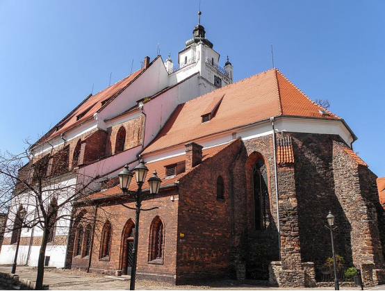
Gothic Church of Christ Saviour

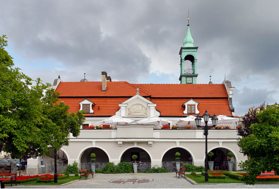
Renaissance-Baroque Kluczbork Town Hall
-We start the walking trail in the Market Square. In its center, which used to be a market square in previous epochs, stands the town hall built in the 18th century, with two front tenement houses remaining from the former baroque "Twelve Apostles" complex. Then we enter Piłsudskiego Street, which serves as the city's representative promenade. One of the most valuable historic buildings in the city stands here - the Gothic church of Christ the Savior, built in the fourteenth century with a beautiful rococo interior. From the church tower, which is open to the public, you can admire the panorama of the city. The entrance to the tower is extremely interesting as we can see the antique clock mechanism and architectural details.
-Leaving Piłsudskiego Street, we enter Mickiewicza Street in a straight line. Here, on the right, we can see a historic tenement house, which houses the Kluczbork House of Culture, and on the left, the historic building of the Polish Post Office. 50 meters further stands the historic building of the Adam Mickiewicz Secondary School Complex (former Gustav Freytag Gymnasium). From Mickiewicza Street, turn left and come to Puławskiego Street, where on the left we pass the old defensive walls erected in the 15th century. We pass the defensive walls and come to the Kościuszko pond, where we can rest for a moment on the benches around the pond with a fountain or go to the fisherman's house by the pond, where there is a cafe. We pass the water reservoir and turn left.
-We are on Szpitalna Avenue, which in a straight line, after crossing Curie-Skłodowska Street, borders on the municipal park, which is the largest green complex in the city. The Monument to the Victims of World War I and the city fountain are located here. On the outskirts of the park, in the former drained marshes, stands the Church of Our Lady of Help of Christians in a characteristic neo-Gothic style.
-Leaving the park, we come to Katowicka Street, where on the right we can see the characteristic building of the Municipal Office and the County Office. We go towards the roundabout at Pl. Niepodległości, where we can see a tenement house with a stylish corner design. From here, in a straight line, we can see the building of the Jana Dzierżon, which stands out in the city's buildings with a characteristic water tower. We pass the Zamkowa restaurant, turn left and enter Krakowska Street.
-Leaving the promenade behind, we return to the market square from the eastern side of the city, where our walk ends. We can rest here in restaurants located around the market square.
Ⅵ.History and Culture
-Archaeologists have determined that a settlement existed at the location of present-day Kluczbork by 1000–800 BCE. The Germanic Scirii and Bastarnae settled in the vicinity, and were followed c. 100 BCE by Celts and various Germanic tribes, including Silingi and Vandals. The latter left Silesia c. 400 and West Slavs came to the region in the 7th century (see Silesians). In the late 10th century the Silesian territory was included to the just established Polish state by its first historic ruler Mieszko I of Poland.
-In the 13th century the Knights of the Cross with the Red Star acquired territory near Wrocław, including the villages Młodoszów, Kuniów, and Chocianowice. The Knights built a settlement on November 2, 1252. Named Cruceburg, it received Magdeburg rights on February 26, 1253, the official date for founding of the town. The Knights adjudicated in the town until 1274, when it started to be administered by a vogt of local Silesian dukes and juries were introduced. As a result of the fragmentation of Poland, Kluczbork was part of various Polish duchies ruled by the Piast dynasty: Duchy of Silesia until 1293, Duchy of Głogów until 1312, Duchy of Oleśnica until 1323 and Duchy of Legnica until 1341, when it came under direct rule of the King of Poland, Casimir III the Great. In 1356 it passed to the Czech Crown Lands, and it soon returned under the rule of local Polish dukes of the Piast dynasty, as part of various duchies. From 1536 it was part of the Piast-ruled Duchy of Brzeg until its dissolution in 1675. Afterwards it was incorporated into the Habsburg-ruled Czech Kingdom.
-Renaissance-Baroque Kluczbork Town Hall
-A mint operated in Kluczbork during the reign of Duke Bolesław III the Generous, in the early 14th century. In 1426 Duke Louis II of Brzeg granted Kluczbork privileges of a salt market in 1426. For centuries the town was inhabited by a predominantly Polish-speaking populace. The textile industry began to grow in importance in 1553, but suffered a fire in 1569. Another great fire destroyed many houses on December 8, 1562. On January 25, 1588, the day after the Battle of Byczyna, Polish troops under Jan Zamoyski plundered the city. The townspeople accepted the Protestant Reformation in 1656 and converted the local Roman Catholic Church into a Lutheran one. The Polish Brethren settled in the city after 1660, and organized their synods in the city in 1663 and 1668. The town had a population of approximately 1,000 inhabitants in 1681.
-A fire on April 23, 1737 almost completely destroyed the town, leaving only a few houses and the castle unscathed. Several years of rebuilding passed before it reached its previous size.
-Cruceburg (later spelled Creutzburg, Creuzburg, Kreuzburg) was originally part of the Lower Silesian Duchy of Brieg, but in the 18th century came to Upper Silesia. Citing an inheritance treaty, which was not honored by Habsburg rulers, King Frederick II of Prussia invaded Silesia in 1740 and began the Silesian Wars. Kreuzburg was annexed by the Kingdom of Prussia in 1741 and became part of the Province of Silesia.
-The town became part of the German Empire upon the unification of Germany in 1871. It had a predominantly German-speaking population of 5,238 in 1875, although it was located in a Polish-dominated district. The population grew to 8,750 by 1895 and 10,236 by 1900.
-Memorial plaque at the site of the former German Oflag VIII A prisoner of war camp and Ilag VIII/Z camp
-Following the Treaty of Versailles after World War I, Kreuzburg was involved in the Upper Silesian referendum in 1921. 95.6% (37,957 votes out of 39,703 participants) voted to remain within Weimar Germany instead of joining the Second Polish Republic. It became part of the Province of Upper Silesia; to differentiate between other places named Kreuzburg, it was known as Kreuzburg O.S. (referring to Oberschlesien, or Upper Silesia). By 1939 the town was the seat of Landkreis Kreuzburg O.S. and had 11,693 inhabitants. After the Nazi Party took power in Germany in the 1930s, anti-Polish and anti-Jewish sentiments became more visible. In 1936, the Germans changed the Polish-sounding street names, and in 1938, during the Kristallnacht they burned down the synagogue, built in 1886. During World War II, in 1939, the Germans established the Oflag VIII A prisoner of war camp in the city, and in 1943 they transformed it into the Ilag VIII/Z camp for interned citizens of the United Kingdom and the United States. The Germans evacuated the populace before the advancing Soviet army in January 1945.
-The town was captured by the Soviet Union's Red Army in 20 January 1945 toward the end of World War II. Following the war in 1945, the town became part of Poland. A majority of the Germans remaining in the town fled or were expelled and replaced with Poles from Poland's eastern provinces newly annexed by the Soviet Union, as well as from other parts of Poland.
-A monument of Jan Dzierżon, pioneering and world-famous Polish apiarist, was unveiled in 1981.
Ⅶ.Other Information
Kluczbork is a town in southwestern Poland with 23,554 inhabitants (2019), situated in the Opole Voivodeship. It is the capital of Kluczbork County and an important railroad junction. In Kluczbork the major rail line from Katowice splits into two directions – westwards to Wrocław and northwards to Poznań. It is also connected with Fosowski
Ⅷ.Contact Information
Mayor Jarosław Kielar
Town Hall in Kluczborkul. Katowicka 146-200 Kluczbor Community Kluczbork
NIP: 751-165-84-19
E-mail:um@kluczbork.pl
Contact number
Tel. (77) 418-14-81
Fax (77) 418-22-30
