Skanderborg,Denmark 作者: 来源: 发布时间:2021-09-29
一、人口,面积,所属地区
Population: 62,678
Area: 462 km²
Municipality in Midtjylland
二、自然地理
Skanderborg Municipality is a municipality in Region Midtjylland on the Jutland peninsula in central Denmark, just southwest of Aarhus and is a part of the East Jutland metropolitan area.
The municipality has two of the three highest natural points of terrain, namely Møllehøj at 170.86 metres (560.56 ft), and Ejer Bavnehøj at 170.35 metres (558.89 ft), in the southern part, southwest of the city of Skanderborg. Himmelbjerget at 147 metres (482.28 ft), is in the western part of the municipality, and Yding Skovhøj at 170.77 metres (560.27 ft), is in neighboring Horsens municipality, west of the other two highest points of natural terrain.
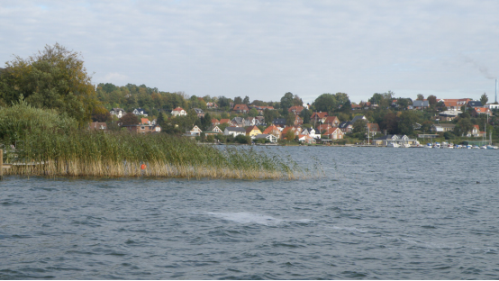
Skanderborg is the municipality's main town, and serves as the seat of the municipal council. It is situated on the north and north eastern brinks of Skanderborg Lake and there are several smaller ponds and bodies of water within the city itself, like Lillesø, Sortesø, Døj Sø and the swampy boglands of Eskebæk Mose. Just north of the town on the other side of Expressway E45, is the archaeologically important Illerup Ådal. Over time, the town has grown into a suburb of Aarhus to the north east, connected by the urban areas of Stilling, Hørning and Hasselager.
In the southern part of the town is the deer park of Skanderborg Dyrehave, located within Skanderborg Forest. The deer park was established around 1580 by King Frederik II to facilitate his interest in hunting. The park area was fenced and roe deer, red deer, wild boars and rabbits were released. Pheasants, gray partridge and turkeys were raised and pools and fishing ponds were dug.
Skanderborg Sø was created during the last ice age and formed from a melting block of ice left behind; a so-called kettle hole. The lake has an irregular shape divided into two larger lake-areas known as Hylke and Store Sø respectively, with a total surface area of 8.6 square kilometers. The lake has an average depth of 8 meters and up to 18.8 meters at the deepest spot. It holds approximately 49.3 million cubic meters of freshwater 23.5 meters above sea level and empties into Mossø, by the short stream of Tåning Å in the west. There are a number of small isles in the lake; Kalvø, Æbelø, Sct. Thomas and Sct. Helene.
Transport
The most important hubs for public transport in Skanderborg Municipality are train stations as well as central bus stops, where crossings between several lines are possible.
Skanderborg Station
Skanderborg Municipality has acquired the post office area at Skanderborg Station, and efforts are being made to relocate the hub for bus traffic in Skanderborg to this area. The existing bus terminal at Møllegades parking lot is included in the areas laid out for the realization of a parking garage for up to 5 floors. In order to ensure continued good bus service to Skanderborg Midtby, a new bus stop is expected at the Health Center on Hospital Road.
In the station area / terminal area itself, a good and informative signage regarding the switching possibilities must be ensured; including the location of the various bus lines, teletaxa, etc.
Other nodes in Skanderborg
At the Campus area in Højvangen, there is a hub for public transport at the stops at Ladegårdsbakken, and at Højvangen. The traffic between the individual stops must be able to take place in a traffic-safe manner, e.g. by using the path tunnel under Ladegårdsbakken, and the focus is on ensuring that the path connections from the nodes and to the Campus area are safe and secure to use.
At the Health Center on Hospital Road, a new hub for public transport is expected in the city center. Here, accessibility and road safety must therefore be improved for all types of traffic. The areas along Hospital Road have the potential for urban densification and urban transformation. In any further planning for the urban congestion and transformation of the areas, the focus will be on making path access between the area and the city center more secure and attractive, and to improve the parking and waiting facilities for cycling and pedestrians.
In the area at Møllegade, Kirkevej and Vroldvej there are existing hubs for public transport at the stops along Møllegade and Vroldvej. The area has potential for urban densification and urban transformation. In any event, Further planning for the urban urbanization and transformation of the area will be focused on making the path access through the area to and from school, nearby institutions and the shopping area more secure and attractive, and to improve the parking and waiting facilities for cycling and walking.
Hørning Station
In Hørning, train traffic and bus traffic are separate, with the intersection of the bus lines located on Århusvej by Stationsvej. Significant and informative signage must be ensured between the bus junction and the train station.
The train station must ensure that there is sufficient parking for both cars and bicycles.
Ry Station
In Ry, the train station is a transfer point to local bus routes. It must be ensured that this changeover can take place as expediently as possible. Likewise, good and informative signage must be ensured.
Galten-Skovby and Låsby
Galten-Skovby and Låsby are not currently served by train lines, and all public transport is by bus. The traffic hubs are located at the central bus stops, where are alternatives to other bus lines. Access to these key stops must be ensured and parking facilities should be adequate.
New train line Aarhus-Silkeborg.
The state is in the process of preparing a possible new rail connection between Aarhus and Silkeborg. The railway is expected to get its trace along the Aarhus-Silkeborg / Herning motorway and stop at both Galten-Skovby and Låsby.
Transit places
At all motorway connection facilities in the municipality of Skanderborg (except for the Ejer Bavnehøj connection), connection points have been established.
三、经济发展和规模
In the very short term, the City Council's target is an annual construction level of DKK 125 million. kr. In the short term, it is financed by using surplus liquidity, cf. the standard for cash. In the longer term, it is financed by the profit from ordinary operations showing a profit of DKK 160 million. kr
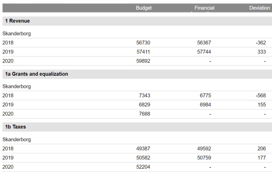
*All amounts are in DKK per. per capita in current prices
四、产业特点重点项目
Skanderborg Municipality is part of the Aarhus Business Region collaboration - a collaboration between 12 East Jutland municipalities. The 12 municipalities are Hedensted, Horsens, Skanderborg, Samsø, Odder, Norddjurs, Syddjurs, Randers, Silkeborg, Favrskov, Viborg and Aarhus.
A total of one million East Jews - half a million jobs - and the country's largest growth area outside the metropolitan area. Behind the network of the 12 municipalities are 12 city councils and a large number of partners from business, organizations and knowledge institutions working together to boost productivity and growth in East Jutland.
The occupational strengths are industrial production, food innovation and information and communication technology.
The projects that Business Region Aarhus is working on:
INDUSTRY PROJECTS 4.0
The industry in the Aarhus Business Region draws the load as one of the country's most important export sectors. In order to contribute to continued growth, we have established collaborations between companies and educational institutions, so that companies have access to new knowledge and the future of labor.
Industrial companies account for about one fifth of East Jutland export companies, but account for as much as 64% of the region's total export turnover. This is a much higher proportion than the country's other growth regions, and in total, the industrial companies in the Business Region Aarhus export for DKK 85 billion annually.
The manufacturing industry is part of Danish history and identity and continues to contribute to thousands of jobs in East Jutland. However, even closer cooperation between production companies, knowledge institutions and research is required in order for us to attract and retain qualified workers. Business Region Aarhus strives for a sharp focus on skills, investment and lower production costs, so “Production and Knowledge” will continue to be one of our strengths.
FOOD
As one of the world's strongest power centers in food development and production, food companies in East Jutland contribute significantly to the Danish economy. One third of Denmark's food exports come from here.
The food cluster in Business Region Aarhus is the European epicenter for food innovation. The companies in the Business Region Aarhus are international leaders in business specializations in the food industry.
五、风景名胜,景点
Owns Bavnehøj and Møllehøj
Address: Owner Bavnehøjvej 4, 8660 Skanderborg
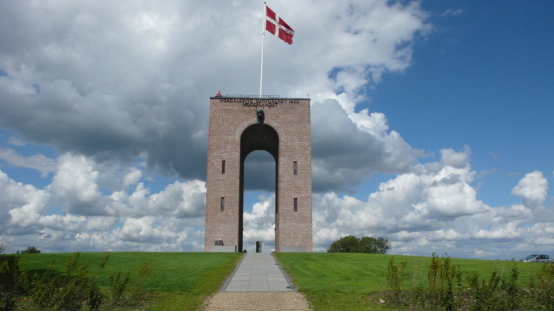
Owner Bavnehøj together with Møllehøj is the highest natural point in Denmark. The view from the top is magnificent - not least from the 12.5 meter high reunion tower - erected in 1924. A unique moraine landscape, created in the latter part of the Third Ice Age, winds south of Ejer Bavnehøj. Other well-known highlights in "Ejer Bjerge" are Møgelhøj, Lindbjerg, Kvejnbjerg and of course Yding Skovhøj. Here the East Jutland border is very clear. In clear weather you can see all the way to Samsø and the Little Belt Bridge.
A long-range binoculars are erected at the top of the tower during the tourist season and there are sight lines in every direction.
Vestermølle Museum
Address: Oddervej 80 D, 8660 Skanderborg
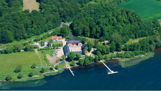
Visit the Mill Museum as well as the Virtual Museum at Vestermølle and get an insight into the great importance of the cooperative movement to agriculture and society in general.
In the old grain magazine, where there is today the Virtual Museum, you get an exciting insight into the past 500 years of Danish history seen from Vestermølle.
Also visit the Okkerhut, which was inaugurated on Valborg Evening, April 30, 2016. The oak hut is located next to the Jenkilden holy spring, whose water - according to the stories - has healing power. Here, the paralytic should have thrown the crutches, the blind have been seen and other diseases, even the affectionate, cured.
The ocher hut is also a Nature Room, where wandering in the area's unique nature can take a
rest in shelter from the sun, wind and rain.
In the garden lies the beautiful Knights Hall, which is used today for parties and meetings and is the setting for Skanderborg Municipality's civil weddings in the summer. A beautifully renovated gem in 2010.
Vestermølle is beautifully located down to Skanderborg Lake, and there is access from both the road and the waterway. Sail with the good ship Dagmar from the City Park and combine the trip with lunch or coffee at Restaurant Vestermølle.
六、历史文化
On 1 January 2007 Skanderborg municipality was, as the result of Kommunalreformen ("The Municipal Reform" of 2007), merged with Galten, Ry, and Hørning municipalities, along with Voerladegård Parish from Brædstrup municipality, to form the present, expanded "Skanderborg Municipality". The former municipality covered an area of 143.22 km², and had a population of 21,745 (2003). Its last mayor was Aleksander Aagaard, a member of the agrarian liberal Venstre political party.
Skanderborg is an old town and the area have revealed traces of human settlements, dating from the earliest Nordic Stone Age. A seasonal camp from the Ertebølle culture, was found here in the 1930s for example, near the former Ringkloster on the southern brinks of Skanderborg Lake.
The town sprawled around the former Skanderborg Castle, founded at some point during the early Middle Ages and in 1583 Skanderborg was granted a municipal charter.
Religious orders
The town of Skanderborg has attracted several religious communities over the years, especially in the early Middle Ages. The long gone Ring Abbey founded by Benedictine nuns in the 12th century, was once situated on the southeastern brinks of Skanderborg Lake. The last buildings burned down in 1715 and now there is a mansion at the site. There also used to be a Dominican monastery on the small islet of Kalvø in the middle of the lake. The monastery was founded by the Black Friar Order in the first half of the 12th century, along with a small harbour, but in 1168 there were only two monks left and the Cistercian Order took over. The Cistercians came here after they had failed in founding a proper monastery at several nearby locations since 1165. In that year, they embarked on a mission from Vitskøl Abbey in Himmerland, to found a daughter community in the diocese of Aarhus and tried at Sabro, at Sminge near Silkeborg (Sminge Abbey), and then near the village of Veng (Veng Abbey). The Cistercians eventually felt too isolated on the small isle of Kalvø, often cut off from the mainland for days and weeks even when the weather was harsh, and after just four years, they gave up here, too, and moved to Rye between Mossø and Gudensø, a few kilometres west of Skanderborg. Here they founded Øm Abbey in 1172.
Skanderborg Castle
The royal residence of Skanderborg Castle was arguably the most important and influential building in the history of Skanderborg, but it was demolished stone by stone during the 18th century. Founded at some point in the early Middle Ages around 1200, King Frederik II had the old medieval castle radically rebuilt and expanded around 1570. His project was grandiose in scale. An entirely new large Renaissance palace was erected and the deer park of Skanderbrog Dyrehave was constructed nearby, amongst other undertakings. Stones from the demolished Øm Abbey west of Skanderborg were used as construction materials. Many of the original structures survived the project and were incorporated into the new buildings, amongst these the old castle chapel. In the 12th-16th centuries, Skanderborg Castle functioned as the traditional hunting retreat of the Danish kings.
Demolition
In the years of 1717-22, King Frederik IV began demolishing the old original medieval structures and replaced the former fortifications with terraced gardens. Only the bell tower of the still existing castle church remained. In turn however, Skanderborg Castle saw a decline in popularity and attention by the royal family, and in 1767, the castle with associated gardens was sold at auction. Commoner Hans Lauritzen bought the royal property for the sum of 3004 Rigsdaler, while the castle church with furnishings and bells was granted to the town of Skanderborg. In April 1768, the demolishing of Skanderborg Castle began and nothing remains of it today, except the old castle church.
Present buildings and structures
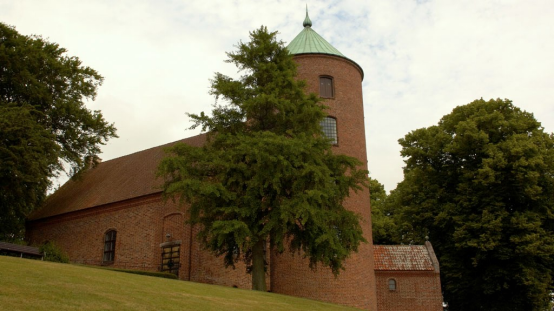
The town of Skanderborg has a total of three churches, and Skanderborg Castle Church used to be part of the former Skanderborg Castle.
The cultural centre of Kulturhuset, located in Byparken (the city park) in the center of Skanderborg, was designed by native architectural firm Kjær & Richter and built in 1998. It houses the former library of the town, theatre and concert halls, a cinema, a three story foyer with changing exhibitions and a café. Surrounding the buildings, are a Greek theatre with 500 seats, a playground and a beach volley field, amongst other facilities, as the city park itself is perceived as part of the cultural centre.
The square of Højvangens Torv, in the northeastern parts of the town, is the center of the educational campus known as Campus Højvangen. The campus is the site of educational institutions such as a public school, a business college (an HHX institution), technical college (an HTX institution under Aarhus Tech), an adult educational centre, Skanderborg Gymnasium etc., situated in a sculpture park. The gymnasium was designed by architectural firm Friis & Moltke and built in 1973.
The Village of Sølund is an accommodation facility and home for people with extensive physical and mental handicaps. It is located within the park of Skanderborg Dyrehave near the pond of Lillesø, close to town. The main buildings were erected in 1935 and designed by architectural firm C. F. Møller Architects.
Skanderborg Museum has their headquarters at Adelgade 5, a former bailiff (Danish: foged) house from the mid 18th century. The buildings are located in the oldest parts of the town, next to the pond of Lillesø. The Museum functions as an umbrella organisation for several museums in and around the town of Skanderborg, including Museet på Adelgade, Øm Kloster Museum, Museet på Gammel Rye Mølle, Ferskvandsmuseet and Skanderborg Bunkerne. Skanderborg Bunkerne is a World War II museum, fitted out in the abandoned German bunkers in Skanderborg Dyrehave. The German Luftwaffe built their Danish headquarters here and one of the bunkers later found use as the command centre for the civil defence agency during the cold war era. Øm Kloster Museum is located outside the town, at the old ruins of Øm Abbey on the northern brink of lake Mossø. Skanderborg Museum is the responsible organisation for archaeology and archiving of the cultural history within the municipality.
七、联系方式
Mayor: Frands Fischer
Address: Skanderborg Common 1, 8660 Skanderborg
Telephone: 8794 7000
Mail: skanderborg.kommune@skanderborg.dk
Facebook: https://www.facebook.com/skanderborg.dk
Website: https://www.skanderborg.dk/
Office Hours:
Monday, Tuesday and Wednesday at. 10 am - 1 pm
Thursday: 10 am - 5 pm
Friday: 10 am - 1 pm
