Aspremont 作者: 来源: 发布时间:2021-09-27
I.Population and Area
Region: Provence-Alpes-Côte d'Azur
Department: Alpes-Maritimes
Code Insee : 06006
Code postal : 06790
Total Area: 9.44km²
Population in 2017: 2 187
Population Density: 232 /km²
Details: The altitude of the city hall of Aspremont is approximately 499 meters. Its surface area is 9.44 km². The latitude and longitude of Villers are 43.785 degrees North and 7.243 degrees East. Towns and villages near Aspremont are: Castagniers (06670) at 1.26 km, Tourrette-Levens (06690) at 2.79 km, Colomars (06670) at 3.43 km, Saint-Blaise (06670) at 4.21 km, Carros (06510) at 4.48 km.
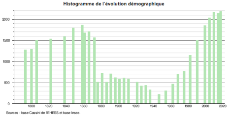
Histogram of demographic change
Sources : http://www.cartesfrance.fr/carte-france-ville/06006_Aspremont.html
II.Natural Geography
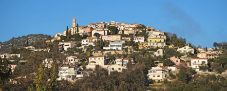
Geographical environment: Aspremont is located some 10 km north of Nice and 5 km east of Carros. Access to the commune is by road M414 (Route de Nice) from Nice in the south, by the M14 road from Saint-Blaise in the north, and by the M719 from Tourrette-Levens in the east. Apart from the village there are the towns of Les Salettes, La Plaine, La Valliere, and La Prairie near the village and Les Templiers, Bassac, Cabanes Bletonnieres, and Gibeste in the south. The commune is rugged and heavily forested in the west and east. The Magnan river rises near the village and flows south through the heart of the commune then to the Mediterranean Sea in the south-west of Nice. Aspremont is one of sixteen villages grouped together by the Métropole Nice Côte d'Azur tourist department as the Route des Villages Perchés (Route of Perched Villages). The others are: Carros, Castagniers, Coaraze, Colomars, Duranus, Èze, Falicon, La Gaude, Lantosque, Levens, La Roquette-sur-Var, Saint-Blaise, Saint-Jeannet, Tourrette-Levens and Utelle.
Climat: The climate in Aspremont is warm and temperate. In winter, there is much more rainfall in Aspremont than in summer. According to the Köppen-Geiger classification, the climate is of the Csb type. The average annual temperature in Aspremont is 12.5 ° C. The average precipitation over the year is 832 mm. The driest month is July, with 25 mm of rainfall. In November, precipitation is the most important of the year with an average of 110 mm. In July, the average temperature is 20.5 ° C. July is therefore the hottest month of the year. January is the coldest month of the year. The average temperature is 5.3 ° C during this period.
Transport:
(1) Bus: Municipality served by the Ligne of Azur network. The Lines of Azur network offers single pricing for the entire Nice Côte d'Azur Metropolis. Validation is mandatory each time you board the bus, regardless of the ticket used. To consult all the prices, click here: linesdazur.com Aspremont is located just about 10 km from Nice. To get Aspremont from Nice, you can take the bus line 76 for 23 minutes, or take a taxi for about 17 minutes.
(2) Airport: Closest airport to Aspremont is Nice Côte d'Azur Airport (NCE). Distance from Nice Côte d'Azur Airport to Aspremont is 8.9 miles / 14.3 kilometers. Besides, distance from Cannes – Mandelieu Airport to Aspremont is 22.3 miles / 35.8 kilometers. Cannes – Mandelieu Airport is located approximately 1.2 miles / 1.9 kilometers southeast of Mandelieu-la-Napoule and about 3.0 miles / 4.9 kilometers west of Cannes. IATA airport code is CEQ.
Sources :https://fr.climate-data.org/europe/france/provence-alpes-cote-d-azur/aspremont-326108/
https://www.rome2rio.com/s/Aspremont/Nice
https://www.closestairportto.com/city/france/aspremont/
III.Economy
Aspremont Accounting income in 2018 was 435 420 €, or 196 € per inhabitant.
Self-financing capacity in 2018 was 435 420 €, or 196 € per inhabitants.
Income: According to Insee, in 2014, the inhabitants of Aspremont earn on average € 2 994 net per month, or € 35 926 net per year,higher than the average of France.
Unemployment rate: In 2016, its unemployment rate was 8.3%, which was much lower than the French average of 11%.
Companies: In 2017, the total number of companies in Aspremont was 202, and there were 27 new companies.
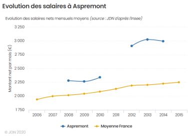
Evolution of average monthly net wages
Sources : http://www.journaldunet.com/management/ville/aspremont/ville-06006/budget
http://www.journaldunet.com/business/salaire/aspremont/ville-06006
http://www.journaldunet.com/management/ville/aspremont/ville-06006/emploi
http://www.journaldunet.com/management/ville/aspremont/ville-06006/entreprises
IV.Industrial Characterisitics
According to the official website of Aspremont, the commerces and services are concentrated on real estate, restaurants, hotels, etc. The main industries of Aspremont are agriculture and tourism.
Tourism: You can find ten main hotels from the official website, like Hostellerie d’Aspremont, Meublé de Tourisme 4 couchages, etc. There are 2 four-star hotels, 2 three-star hotels. You can also find the website of each hotel. https://aspremont.fr/hebergements/
Agriculture: The soil and the sun have favored the cultivation of vines, olive trees and fruit trees, especially fig trees; its production of olive oil and wine was renowned in the county until the late 19th century.
V.Attractions
1.Mont Chauve d'Aspremont
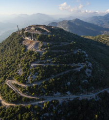
This circuit starts from Aspremont, one of the famous “perched villages” of the Cote d’Azur, and climbs up to Mont Chauve at 853m to give spectacular views of the Baie des Anges and the “collines”, or hills, surrounding Nice.
Although not extremely tough, the trail takes in all sorts of terrain; from rocky singletrack to set a trail runner’s heart a-flutter, to open plateaus filled with wild flowers and butterflies. The route starts off just beside the childrens playpark and football pitch that you pass when entering the village. Wooden hiking signs point the way to Mont Chauve via a path that runs alongside some allotments and comes out on to a long driveway. When the driveway turns into a gravel path look to your right for another hiking signpost - this is where you’ll pick up the start of the trail. Twisting uphill along a rocky path you’ll quickly gain enough height to be looking down on Aspremont from above. After 20 minutes or so the path flattens out onto a plateau where there are often goats grazing and you can see the city of Nice in the distance.
Take the path to your left up to the old fort if you want to reach the highest point of the hike; the fort itself is nothing spectacular and a bit disappointing, don’t be expecting turrets or drawbridges, but the hike up there is worth the effort anyway for the fantastic view.
Once you’ve started the descent look out for the turn-off to La Baisse de Guigo, it is signposted about halfway down. Follow this road until just before it bends round to the right, look to your left and you’ll see another signpost pointing to a path that scoots off into the bushes.
La Baisse de Guigo is another flattish meadowy area and is great for wildlife spotters - the lavender and other wild flowers make it a haven for birds, bees and butterflies. It is also hunting land though, so take care during September to December. Don’t panic and dive for cover every time you hear gunfire though, there is a military training facility nearby and you can often hear loud bangs from the shooting range.
After you come through the Baisse de Guigo keep a keen eye out for yellow paint markers on trees and/or rocks - they are not very obvious and there are a few route deviations where you could easily end up on the wrong trail. The correct route makes a bit of a dog leg back up towards Aspremont.
This final stretch is downhill, quite steep and very rubbly underfoot - if you are as prone to stumbling as yours truly then hiking poles might not be a bad idea. You’ll pass through a shady forest area before coming back to the driveway from where you started.
Distance: 8.5km
Time: 2.5 hours
Google Maps: https://maps.google.com/maps?q=http:%2F%2Fwww.mapmyfitness.com%2Froutes%2Fkml%2F484736226%2F
Source: https://www.seenice.com/reviews/aspremont-mont-chauve-circuit-nice-area-676166
2.Vallon de Donaréo
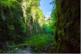
Due to the risk of landslides, the dark valley of Donaréo is now closed to the public until further notice.
The dark valley of Donaréo ... An expression, in itself swollen with mystery, that goes from amateur of the unusual to the amateur of the unusual ... When it was whispered to me during a conversation, like a secret not to be too spread out, I initially believed in a movie title. But in fact, the dark valley of Donaréo is a completely unusual place a few kilometers from Nice which I would never have suspected! That kind of place where you feel like you've been catapulted into another world. This kind of place you would never have been in Nice.
So if you like unusual discoveries, let go of your beach towel, forget the 10 must-to-see of the city of Nice for 5 minutes, put off the pan bagnat until later ... And follow me for an amazing walk in the valley obscure of Donaréo!
During this hike, you will discover the mysterious Vallon du Donaréo. The start of this hike is a few kilometers from Nice, right next to the necropolis of Nice. This area is classified Natura 2000, take care of this ecosystem!Remember to take a helmet with you to avoid rockfall injuries.
Address: 06790 Aspremont, France
Source: https://laterresurson31.fr/vallon-obscur-du-donareo-cote-azur/
3.Mont Cima
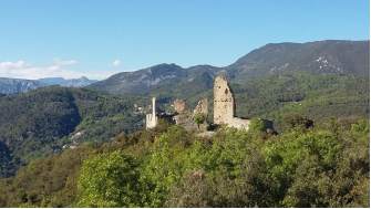
You will be able to enjoy a very pleasant path without difficulties from which you will enjoy a beautiful view of the town of Tourette-Levens and the ruins of Châteauneuf de Contes, 35 minutes later the 844 beacon will mark the direction to the summit from Mount Cima, from this point you will have 20 minutes of sustained ascent to reach the summit. Mount Cima will be the highest point of your walk from which you will enjoy a 360 ° landscape between sea and mountain.The rest of the hike passes by the 844 tag, continue downhill for 15 minutes on the GR5 to reach the forest track and beacon 820 From this point there is a path on the map but which on the ground is far from being very present so we will continue on the forest track for 1.5 km to join in a bend to the left a plateau at the end of which you will find a path in the middle of the vegetation marked out by pieces of rubalise allowing you to reach the ruins of the castle of Saint-Blaise and the beacon 825. Association for the preservation of the castle of Saint Blaise A on leaving your visit to the ruins and reading the information panel (indoor access prohibited to the public) take the track on the right which will bring you back to the forest track on which you will have to do another 1km before ant to start a descent on a relatively steep winding road (270 m negative over 1.2 km) The route will lead to the M14 departmental road, turn left towards Aspremont for 500 m and join the 876 marker which will be the start of the last ascent of this hike. Allow 1 hour of arduous and sustained climb that does not offer respite to find yourself at the foot of Mount Cima (so take your time to climb 350m positive for 2kms) The end of the hike will engage on the forest track on your left and join the path and the 843 beacon that you crossed at the start of the walk, the return to your vehicle will be via the uphill path. In summary this hike is very pleasant but remains relatively sporty by the difference in height and its length, therefore rather reserved for seasoned walkers. In addition to this, you need to know more about it.
Source: https://vuederando.weebly.com/aspremont-mont-cima.html
4.Le Chateau d’Aspremont
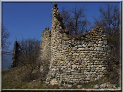
North of Nice, on a slope overlooking the left bank of the Var, Aspremont has seen its community move three times over the centuries. It is on the original site, at the top of Mont Barri at an altitude of 815 m north of the current village that the ruins of Aspremont-Villevieille are found surrounding the remains of a castle testifying to constructions built around the year thousand.
Built on a rocky ridge of about 2000 meters long, bordered by a sheer drop, on a platform not exceeding 15 meters wide, this work offers a perfect example of these effective, isolated places of defense, surrounded by Steep slopes, on an elongated and narrow ridge, sought after around the 11th and 12th centuries. The interesting ruins of a 12th century Romanesque chapel are included within the ramparts.
The population victim of the plague epidemic of 1327, undoubtedly propagated by the pollution of the water in the cisterns, was completely decimated, resulting in the abandonment of the premises and an installation on the small plateau, below, at the pass where s 'now completes the motorable road. There remain the remains of the chapel of N.D. des Salettes, mentioned in 1246, as the priory of Salettes d´Aspremont.
Source: http://pays-d-azur.hautetfort.com/archive/2006/08/02/un-chateau-ruine-temoin-du-passe.html
5.Eglise Saint Jacques Aspremont
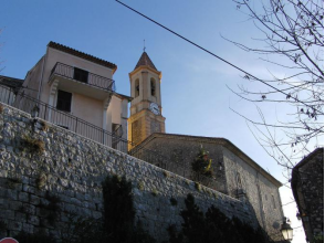
Eglise Saint Jacques Aspremont, whose Gothic nave, decorated with frescoes, is mounted on a ribbed cross. It contains an 18th century altarpiece and a Virgin and Child, a naive statue in polychrome wood.
Located on the medieval site of the Chapel of Saint Jacques in 1320 and consecrated in 1556, we can read two dates on the capitals: 1556 and 1586. The church was redeveloped according to plans by Antonio Spinelli in 1776, in particular the reconstruction of the bell tower. The stucco workers Molinari and Conza collaborated on the work. It is a Gothic nave with side aisles, without window, decorated with frescoes, and mounted on a ribbed cross.
Source: https://www.montnice.fr/cartographie/fr/eglise-saint-jacques-majeur-aspremont
VI.History
The name of village has the first record in 1062,as Aspermun. After the abandonment of the Aspremont-le-Vieux site in 1426, a fortified village was built in concentric circles at the foot of Mont-Chauve on a hill overlooking a path between the Var and the Paillon de Tourrette Valley. Soil and sunshine favoured the cultivation of vines, olives, and fruit trees, particularly fig trees. There was production of wine and olive oil in the county until the end of the 19th century. In 1874 Aspremont had its land area divided to create the new communes of Colomars and Castagniers.
Both protohistoric and Gallo-Roman habitations were located here. Medieval: in 1252 Aspremont was part of the fief of the counts of Provence, and then passed successively to Châteauneuf, Chabaud, Marquesan and Borriglione.
Sources: https://www.aboutfrenchproperty.com/colombes
https://www.beyond.fr/villages/aspremont.html
VII.Other information
Apremont has long history, but today, it hasnot be rewarded as neither flower town(Ville fleurie) or art or history town(Ville d'art et d'histoire) in France.
Sources : http://www.journaldunet.com/management/ville/aspremont/ville-06006
VIII.Contact information
Address of Aspremont town hall:
Mairie d'Aspremont
21, avenue Caravadossi
06790 Aspremont
Phone number: 04 93 08 00 01
Fax: 04 93 08 34 73
Email: mairiedaspremont@wanadoo.fr
Website: http://www.aspremont.fr
Mayor : Alexandre Ferretti (Mandat : 2014-2020)
Sources : http://www.cartesfrance.fr/carte-france-ville/06006_Aspremont.html#mairie
