Agios Nikolaos, Lasithi, Crete 作者: 来源: 发布时间:2021-02-24
I. Population, Area and Transportation
Total Area: 511.7 km2 (197.6 sq mi)
Elevation: 21 m (69 ft)
Municipal unit density: 65/km2 (170/sq mi)
Population: 27,074 (2011)
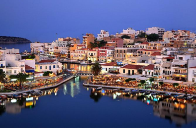
Transportation: Agios Nikolaos is accessible from the mainland and the whole of Europe through Heraklion International Airport, and the many daily ferry services in Heraklion 64 kilometres (40 mi). You can also travel through Sitia airport boarding onto a domestic or charter flight or through its harbour 67 kilometres (42 mi). Recently, the town became host to a department of a Technological Educational Institute (TEI), offering tourism-related courses.
II.Natural Geography (environment and resources)
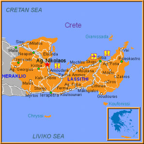
Different to all other towns in Crete, Agios Nikolaos manages to mix - upon the three hills which support its girth - an arty, leisurely, sleepy and yet also bustling place. Built partly atop ancient remains of bygone residents' homes. Also known as Agios Nik or Ag Nik.
The town has three faces to the sea: The Lake and port, Kitroplatia beach and the Marina. Its unique features, start with the lake ("Voulismeni"), a folklore-inspiringly deep body of water which is connected to the sea by a narrow inlet. It is surrounded and overlooked by cafes and restaurants - a busy gathering place for local residents and visitors alike.
Cafes meander between those suited for talking, meeting and lounging, to those playing thump-dump music, nestled alongside more scholarly hang-outs. Standard but good tavernas are overlooked by fine-dining establishments.
As the lake joins the sea with a strip of water under the tiny road bridge and becomes one with it, the microscopic island of Agii Pandes (All Saints) is in view - adding another facet to the three sides of the town. Ferries come and go from the open port area just beyond.
The beach at Kitroplatia is one of the few in Crete to provide that town-centre-by-the-sea beach location, together with its own original restaurant and cafes and a handful of hotels and apartments.
Many churches ply their trade, scattered within the streets of Agios Nikolaos - including the small church which lends its name to the town. Reference Website: https://www.cretetravel.com/guide/agios-nikolaos/-8-u
III. ECONOMY
Traditionally, inhabitants of Agios Nikolaos had two economic mainstays: agriculture and fishery. Agriculture was mostly devoted to olive trees (and olive oil production), wheat, and winery. Fishery was limited to the waters of the Singitic Gulf.
Since the 1980s, tourism replaced fishery and agriculture as economic mainstay. Inhabitants have built own hotels, homes, and pensions or sold-off their agricultural land for real estate purposes. Concomitantly, living standards have risen significantly.
Resources: https://webcache.googleusercontent.com/search?q=cache:KpLTZUpD3wMJ:https://www.wikiwand.com/en/Agios_Nikolaos,_Chalkidiki+&cd=25&hl=zh-CN&ct=clnk&lr=lang_en%7Clang_zh-CN
IV. Industrial Characterisitics
Tourism is developed in Agios Nikolaos. Agios Nikolaos has numerous and high-quality tourist accommodation of all types and classes. Some of the oldest hotels are located in Eleftheria square, but there are many new fine hotels not only in the town, but all along the coast. There are also many cafes, restaurants, bars and shops.
The port of Agios Nikolaos maintained its significance following the end of the Venetian occupation. The town kept on thriving using its port as a lever for growth which paved the way for its tourism development. In the early 1960’s, “Minos Beach”, the first luxury hotel of the area, was built near the city centre marking the beginning of the first tourism development. It is worth noting that Agios Nikolaos was the first area of Crete to experience tourism development years before the western part of the island.
It is the beginning of a new era for the city. Again in the 1960’s, “Ariadni Hotel”, “Mirabello Beach” and Elounda Beach” opened their gates. Their impact on the tourism sector of the area remains of high importance. In the 1970’s, “Coral Hotel”, “Ermis Hotel” and “Rea Hotel” (currently “Mistral Hotel”) were built within the city centre, meeting the standards of luxury accommodation ever since. The 1980’s brings more growth to Agios Nikolaos with new and larger tourist complexes being built within the city as well as at the outskirts. In the meantime, the area of Elounda is also on the rise, acquiring worldwide fame because of its luxury hotels. Sissi and Kalo Chorio follow suit, especially in the late 1980’s.
The tourism development within the municipality of Agios Nikolaos led to the opening of the Higher School of Tourism Education of Crete (ASTEK), in 1990. The School is still providing education to students from all over Greece. At present, the more rural areas of Agios Nikolaos’ hinterland are experiencing rapid growth especially in alternative forms of tourism.
Reference Website: https://www.agiosnikolaoscrete.com/about/
V.Attractions
1.Lake VouliSmeni
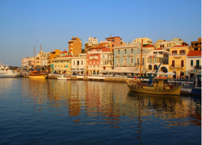
Lake Voulismeni is a former sweetwater small lake, later connected to the sea, located at the centre of the town of Agios Nikolaos on the Greek island of Crete. It has a circular shape of a diameter of 137 m and depth 48.8m. The locals refer to it as simply "the lake". The lake is connected to the harbour of the town by a channel dug in 1907. A panoramic view of the lake can be seen from a small park situated above it.
According to legend, the goddess Athena bathed in it. Every year at midnight turning to Orthodox Christian Easter day, the majority of the population of the town gathers around the lake to celebrate with fireworks, and firecrackers thrown by the people attending that highlight event.
The rocks at the lake are limestone breccias, the result of undersea landslides coming down from the mountains to the north-west of the town. A normal fault which cuts right through the town in a roughly NNE to SSW direction passes directly through the north-western side of the lake, the cliff at the lake is the scarp slope of this fault. Elsewhere in the town the fault was later buried by subsequent underwater landslides. An underground stream that was cut by this fault created a solution sinkhole and a small cave following the disappearance of the overlying sea during the Messinian Salinity Crisis. After only a few hundred thousand years the small cave, dissolved out of the unstable and structurally weak breccia, collapsed creating a deep hole.
The destabilised breccia at the top of this hole subsided into the hole creating a deep funnel-shaped sinkhole which was subsequently filled with freshwater by the still running spring. The creation of the Mediterranean Sea during the Zanclean Flood left a deep, spring-fed, freshwater lake that overflowed via a small stream into the nearby sea.
2.Agios Nikolaos Church
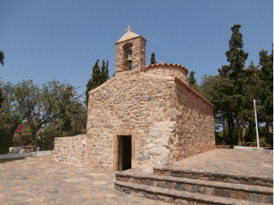
Church of St. Nikolaos is a church listed on the World Heritage List by UNESCO. It is in an isolated location, and visitors must contact the pastor through a local coffee shop before entering. The church has a large number of frescoes dating back to the Middle Ages. There is a statue of Panagia Trifotissa built in the 13th century. It is said that people who stabbed their eyes with the strong light reflected on the salt marshes around Aenos can regain the light by praying in front of the icon. The Church of St. Nikolaos also houses an Ecclesiastical Art Museum of Alexandroupoli.
3.The City of Lato
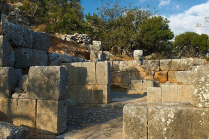
The market square in Lato, Crete, is the earliest city square in the history of human civilization discovered by archaeologists. The square is located in a valley between two mountains. From the main city gate into the city, you can reach this irregular trapezoidal square through a street along the street. The north of the square is equipped with a large stone grandstand, and a tall tower is placed on each side Strengthen the shape of the grandstand and the entire northern end of the square. This grandstand is equivalent to an "audience seat" at the rally and serves the expanded citizens' participation in politics.
The large platform on the south is the noble meeting and activity area, and the two correspond to each other, strengthening the democratic and political color of the square. The center of the square is equipped with a large pool and a memorial altar. This was a wide-ranging design method at the time, reflecting the grandeur of the square. The market square in Lato was the beginning of the development of the city square and also actively promoted the evolution of the city.
VI. History
In the site where the town is built today, used to be the ancient "Lato pros Kamares", which was the harbor of "Lato", an important and powerful city located near the village of Kritsa.
In the Roman and the first Byzantine period it also served as a harbor. During the Venetian occupation, the Venetians built the fortress Mirabello(meaning beautiful view), in the site where the Prefecture building stands today.
Nothing of the fortress is saved today, but it gave its name to the Prefecture and to the bay, that is called Mirabello. When the Venetians built another port in the area of Elouda in the northwest, named "Porto di San Nicolo", the importance of the harbor of Agios Nikolaos lessened. The city is named after the small Byzantine church of Agios Nikolaos, located on the peninsula.
The church has fine frescoes from the 8th, 10th and 11th century. Agios Nikolaos is probably best known as a tourist town that serves as a hub to the twenty or so small villages and farms that make up that part of Lassithi.
Tourist attractions include the small lagoon Lake Voulismeni, small beaches in the town, the tiny island of Agioi Pantes, the archaeological museum, the local flora exhibition “Iris” and numerous fairs. Just a short ferry ride away from Agios
VII. Other Information
Near the town there's an archaeological site of ancient Priniatikos Pyrgos. It appears to have been first settled in the Final Neolithic era, circa 3000 BC. Activity on the site continued throughout the Minoan Bronze Age and the Classical Greek and Roman periods, spanning a total of up to 4,000 years. Since 2007, Priniatikos Pyrgos has been undergoing excavation by an international team under the auspices of the Irish Institute of Hellenic Studies at Athens.
Church of St. Nikolaos is a church listed on the World Heritage List by UNESCO.
VIII.Contact Information
Mayor: Antonis Zervos
Municipality Website: http://www.dimosagn.gr/
E-mail:mstamataki@dimosagn.gr / afaitaki@dimosagn.gr
Agios Nikolaos Municipality
Xirokampos area
72100, Agios Nikolaos
T. +30 2841 340125
info@agiosnikolaoscrete.com
