Stirling, Scotland, UK 作者: 来源: 发布时间:2021-07-29
I. Population and Area
Continent: Europe
Country: The U.K
State/Province: Scotland
City/Town: Stirling
Total Area: 6.488 (sq mi)
Population in 2018: 37.81 (thousand)
II. Natural Geography (environment and resources)
Geography
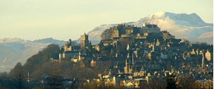
Stirling is renowned as the Gateway to the Highlands and is generally regarded as occupying a strategic position at the point where the flatter, largely undulating Scottish Lowlands meet the rugged slopes of the Highlands along the Highland Boundary Fault. The starkness of this contrast is evidenced by the many hills and mountains of the lower Highlands such as Ben Vorlich and Ben Ledi which can be seen to the northwest of the city. On the other hand, the Carse of Stirling, stretching to the west and east of the city, is one of the flattest and most agriculturally productive expanses of land in the whole of Scotland.
The land surrounding Stirling has been most affected by glacial erosion and deposition. The city itself has grown up around its castle which stands atop an ancient quartz-dolerite sill, known as the Stirling Sill, a major defensive position which was at the lowest crossing point on the River Forth. Stirling stands on the Forth at the point where the river widens and becomes tidal. To the east of the city the Ochil Hills dominate the skyline with the highest peak in the range being Ben Cleuch, although Dumyat is more noticeable from Stirling. The Ochils meet the flat carse (floodplain) of the River Forth to the east of the distinctive geographical feature of Abbey Craig, a crag and tail hill upon which stands the 220 ft (67 m) high National Wallace Monument.
Transport
The City of Stirling is home to a large number of commuters but has fewer commuting to work in other areas, than travel into the city. About half of Scotland's population live within an hour's travel time of Stirling.
Local bus services to districts within the city are almost completely provided by buses operated by First Scotland East. The surrounding towns, like Bridge of Allan, Alloa, Falkirk and Glasgow via Cumbernauld have services from the bus station. Coaches to many Scottish towns and cities also run regularly.
There are also railway links from Stirling railway station, including inter-city rail services to Aberdeen, Dundee, Edinburgh Waverley, Inverness, Glasgow Queen Street, and London King's Cross. Services to Alloa, Bridge of Allan, Falkirk and Dunblane also run. Stirling Council provides some approximate journey times. Working lines include the Highland Main Line, the Edinburgh–Dunblane line and the Croy Line. The station formerly provided direct railway services to Callander and Oban, and to Loch Lomond, over very scenic lines, and a fast service to Dunfermline. Cities with motorways links close to Stirling include Glasgow, via the M80 motorway past Cumbernauld, and Edinburgh, via the M9 motorway past Falkirk. To the north, the M9 provides access to Dunblane with easy links to Perth and further beyond the Central Belt.
Stirling has no airport, but there are international airports at Glasgow and Edinburgh which can be reached within an hour. Light aircraft can be chartered at Cumbernauld Airport.
Stirling used to have steamboats which carried hundreds of passengers a day. There is currently no working port at Stirling but there are plans to develop the river and the harbour which might include links with towns on the Firth of Forth. Since the Forth is tidal at Stirling, development of pontoon style landing stages could potentially allow river taxis and tourist boats to operate during the summer.
III. Economy
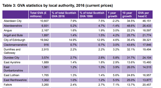

Analysing GVA from the production activities of agriculture, mining, electricity, gas, water and waste by NUTS 3 region. It shows rural areas have a higher intensity of this type of GVA from production activity, reflecting the natural assets of these areas. Almost a fifth (18% of total areas GVA) of GVA on the Shetland Islands came from production activities. Also Aberdeen City and Aberdeenshire (16%), Perth & Kinross and Stirling (16%), and the Orkney Islands (14%) all had a high intensity of GVA from production activities. Those areas with the lowest intensity of GVA from production activities were clustered around the Glasgow region - these were Inverclyde, East Renfrewshire and Renfrewshire (2% of total area GVA), East Dunbartonshire, West Dunbartonshire and Helensburgh & Lomond (2%), and South Ayrshire (3%).
Over a fifth of GVA in both Falkirk and Clackmannanshire & Fife was generated through manufacturing related activities - this was the highest of all NUTS 3 areas in Scotland. South Ayrshire (18% of total area GVA), Inverness & Nairn and Moray, Badenoch & Strathspey (18%), Caithness & Sutherland and Ross & Cromarty (16%), and Angus and Dundee City (14%) all depended on manufacturing activities to A Guide to Gross Value Added (GVA) in Scotland, SB 18-15 40 generate a signifiant proportion of the respective area's economic value. Edinburgh's economy had the lowest intensity of manufacturing GVA across Scotland, at just 3% of the total Edinburgh GVA
Reference Website:
https://www.google.com/search?source=hp&ei=KNEnWqOFIIGu0gS2zZzYDQ&q=%20gva%20of%20Stirling
IV. Industrial Characterisitics
Major industries:
The main industry in Medieval Stirling was weaving wool. Stirling castle was originally built in wood but in the late 13th century was rebuilt in stone.
Victorian Stirling remained a market town and it did not become an industrial centre. However in 1848 the railway reached Stirling and the town began to grow more rapidly. This was partly because well to do people moved to the town and commuted to work in Glasgow. For the middle class new houses were built west of the old town at Abercromby Place, Clarendon Place, Victoria Place, Victoria Square and Queens Road. Also because of its strategic position as the ‘gateway to the Highlands’ Stirling began to develop as a tourist centre. In 1871 Stirling had a population of 11,788. By 1881 that had risen to 14,000. The first electricity was generated in Stirling in 1900 and by 1901 the population of Stirling was over 18,000. The first public library opened in 1902. The first cinema in Stirling opened in 1912 and the last horse drawn trams ran in 1920 when they were replaced by buses. The main industry in Medieval Stirling was weaving wool. Stirling castle was originally built in wood but in the late 13th century was rebuilt in stone
Victorian Stirling remained a market town and it did not become an industrial centre. However in 1848 the railway reached Stirling and the town began to grow more rapidly. This was partly because well to do people moved to the town and commuted to work in Glasgow. For the middle class new houses were built west of the old town at Abercromby Place, Clarendon Place, Victoria Place, Victoria Square and Queens Road. Also because of its strategic position as the ‘gateway to the Highlands’ Stirling began to develop as a tourist centre. In 1871 Stirling had a population of 11,788. By 1881 that had risen to 14,000.
Major projects and related introductions:
City Deal signing: Major step forward for University-led projects
Two landmark projects led by the University of Stirling have today taken a major step forward – following the signing of the Stirling and Clackmannanshire City Region Deal. The University will spearhead the multi-million-pound creation of an Aquaculture Innovation Hub and Scotland’s International Environment Centre under the historic agreement. The Deal – which will see the UK and Scottish Governments seal their collective commitment to a £214 million investment package in the local area – was signed during a special event at Forth Valley College this afternoon. It provides £17m for the aquaculture facility and £22m for the International Environment Centre. Professor Gerry McCormac, Principal and Vice-Chancellor of the University, attended the signing alongside Alister Jack MP, Secretary of State for Scotland, and Michael Matheson MSP, the Scottish Government’s Minister for Transport, Infrastructure and Connectivity.
Reference Website:
https://www.stir.ac.uk/news/2020/february/city-deal-signing-major-step-forward-for-university-led-projects/
https://www.google.com.hk/search?newwindow=1&safe=strict&ei=no6KX625FJXf-gSvlL_QAg&q=industry+of+Stirling&oq=industry+of+Stirling&gs_lcp=CgZwc3ktYWIQDFDG_zlYxv85YJWHOmgBcAB4AIABjAKIAeYEkgEFMS4wLjKYAQGgAQKgAQGqAQdnd3Mtd2l6wAEB&sclient=psy-ab&ved=0ahUKEwitgL61_7rsAhWVr54KHS_KDyoQ4dUDCA0
V. Attractions
1. GARGUNNOCK HOUSE:
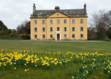
Five acres of mature gardens, featuring rhododendrons, azaleas, trees, flowering shrubs, woodland walks, a walled garden and an 18th century doocot. Gargunnock House is located seven miles west of Stirling. Its front façade dates back to 1794 and initially appears to be Georgian. However, the core of the house is actually much older, dating back to the 17th century. Inside, are many grand rooms, such as the dining room, which sits upwards of 20 people. Gargunnock’s drawing room contains an ornamental piano thought to have once been played by the polish composer Frédéric Chopin.
2. Tombland Alley::
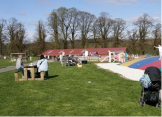
A working mixed farm, featuring a shop selling regional produce, a kitchen serving a selection of home baking and an outdoor maze. Briarlands contains a funyard that contains jumping pillows, a specially designed low energy exercise program for both children and adults. This area also contains a straw mountain tower for kids to climb, go karts, a tyre maze, sand pit and football skills game. The outdoor maize is naturally grown, covering an area of 5 acres and reaching a height of over 6 ft.
Enjoy a light lunch menu of homemade soup and filled rolls or baguettes, as well as a delicious range of home baking, including traybakes, scones, shortbread and meringue nests at Mary’s Kitchen. All baking is done on the premises in a purpose-built commercial kitchen, and the strawberries and raspberries used in tarts and meringue nests are grown on the farm.
3. THE BATTLE OF BANNOCKBURN:
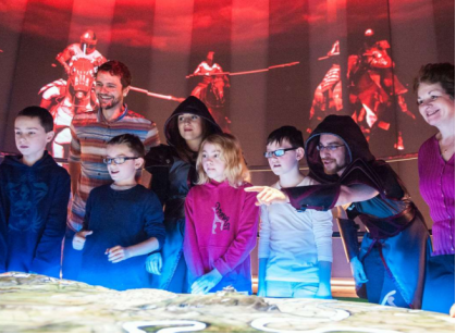
Cared for by the National Trust for Scotland. Prepare for battle at our multi-award-winning visitor centre. The Battle of Bannockburn experience puts you at the heart of the action with cutting-edge 3D technology. Outside, wander across the parkland and admire the restored commemorative monuments, including the iconic statue of Robert the Bruce.
For up-to-date visit information, see here. Located near the historic city of Stirling and in the vicinity of the battleground, the visitor centre expertly harnesses fully-immersive 3D technology to bring this thrilling chapter of Scotland’s story to life. Come and experience medieval combat like never before and discover more about this crucial event in Scottish history.
Reference Website:
https://www.visitscotland.com/destinations-maps/stirling/see-do/
VI. History
Etymology
The origin of the name Stirling is uncertain, but folk etymology suggests that it originates in either a Scots or Gaelic term meaning the place of battle, struggle or strife. One proposal is that Stirling derives from Gaelic srib-linn, meaning "stream-pool" or similar. Other sources suggest that it originates in a Brythonic name meaning "dwelling place of Melyn", with the first element being connected to Middle Welsh ystre-, "a dwelling". The name may have originally been a hydronym, and connected to Brittonic *lïnn, "lake, pool" (Welsh llyn). It is often argued that Stirling is the fortress of Iuddeu or Urbs Giudi where Oswiu of Northumbria was besieged by Penda of Mercia in 655, as recorded in Bede and contemporary annals, however, Blackness Castle may be a more likely candidate.
Ancient history
A stone cist, found in Coneypark Nursery in 1879, is Stirling's oldest catalogued artefact. Bones from the cist were radiocarbon dated and found to be over four millennia old, originating within the date range 2152 to 2021 BC. Nicknamed Torbrex Tam, the man, whose bones were discovered by workmen, died while still in his twenties. Other Bronze Age finds near the city come from the area around Cambusbarron It had been thought that the Randolphfield standing stones were more than 3000 years old but recent radiocarbon dating suggests they may date from the time of Bruce The earliest known structures in Stirling are now destroyed but comprised two Neolithic Cursus in Bannockburn. The earliest known surviving structure is a fort on Gillies Hill were built by Iron Age people over 2000 years ago. Two structures are known: what is currently called Wallstale Dun on the southern end of Touchadam Craig, and Gillies Hill fort on the northwest end of the craig. The Wallstale structure is later than the Gillies Hill fort and is related in form to brochs, these appear to coincide with the Roman period and there are around 40 or so in the wider area. South of the city, the King's Park prehistoric carvings can still be found. The area is likely associated with the Maeatae and their Early Medieval successors the Miathi.The area sits in the middle of the territory known as Manau. Manau survives in four different place names: Clackmannan (The Stone of Manau); Slamannan (The Plain of Manau); Rathmannan (The fort of Manau) and Cromennane in Balfron (The boundary of Manau). All of these names seem to mark the boundaries of Manau meaning it stretched from Balfron to Fife.
Roman and early Medieval
The castle rock has been strategically significant since at least the Roman occupation of Britain, due to its naturally defensible crag and tail hill: the bedrock on which Stirling Castle was built. However, if the Romans were ever on the current castle site then they didn't leave more than a coin or two. Nevertheless, Stirling enjoys a unique position on the border between the Lowlands and Highlands.
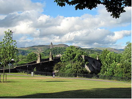
Its other notable geographic feature is its proximity to the lowest site of subjugation of the River Forth. Control of the bridge brought military advantage in times of unrest and; excise duty, or pontage dues in peacetime. Unsurprisingly excise men were installed in a covered booth in the centre of the bridge to collect tax from any entering the royal burgh with goods. Stirling remained the river's lowest reliable crossing point (that is, without a weather-dependent ferry or seasonal ford) until the construction of the Alloa Swing Bridge between Throsk and Alloa in 1885.
Late Medieval and early Modern
Another important historical site in the area is the ruins of Cambuskenneth Abbey, the resting place of King James III of Scotland and his queen, Margaret of Denmark. The king died at the Battle of Sauchieburn by forces nominally led by his son and successor James IV. During the Wars of the Three Kingdoms, the Battle of Stirling also took place in the centre of Stirling on 12 September 1648. The fortifications continued to play a strategic military role during the 18th-century Jacobite risings. In 1715, the Earl of Mar failed to take control of the castle. In January 1746, the army of Bonnie Prince Charlie seized control of the town but failed to take the Castle. On their consequent retreat northwards, they blew up the church of St. Ninians where they had been storing munitions; only the tower survived and can be seen to this day. The castle and the church are shown on Blaeu's map of 1654 which was derived from Pont's earlier map.
VII. Culture
Walking the Marches is a custom probably started in the 12th century. The only way the town's boundaries could be protected was to walk round inspecting them annually. The walk was followed by a dinner. This was traditionally done by the Birlaw men made up from members of the Seven Trades, the Guildry and Council. In 2014 the tradition was revived after an official abeyance of several years.
There are about sixteen libraries and two mobile libraries in Stirling. The Smith Art Gallery and Museum is now free to tourists and residents alike. Shearer's 1895 Penny Guide to Stirling and Neighbourhood used to list it under "How to spend a few hours on a wet day". The Macrobert Arts Centre has a variety of exhibitions and performances. There are many events at the Tolbooth and The Albert Halls. Stirling has hosted the National Mòd several times: in 1909, 1961, 1971,1987 and 2008.
VIII. Other information
The University of Stirling opened in 1967 on a greenfield site outside the town. Currently there are 11,100 students studying at the university, of which 7,995 are undergraduates and 3,105 are postgraduates. There are 120 nationalities represented on the university campus, with 19% of students coming from overseas. It has grown into a major research centre, with a large Innovation Park located immediately adjacent to the main university campus. Innovation Park has grown since its initiation in 1993, and is now home to 40 companies engaging in various forms of research and development. In January 2008 it was announced that students from Singapore would be able to gain degrees in retail from the University of Stirling in a tie-up with the country's Nanyang Polytechnic (NYP).
Stirling is also home to part of the wider Forth Valley College which was formed on 1 August 2005 from the merger of Falkirk, Stirling and Clackmannan colleges.
There are four main high schools in Stirling itself – Stirling High School, with a school roll of 964 pupils, Wallace High School with 958 pupils, St Modan's High School with 912 pupils, and Bannockburn High School in Broomridge with 752 pupils. All the city's secondary school premises have been redeveloped as a result of a Public-private partnership scheme. Stirling also has a Gaelic-medium unit situated in the city's Riverside Primary School which teaches pupils from across Stirling and Clackmannanshire through the medium of Scottish Gaelic.
IX. Contact information
Mayor/Officer: Mark Irwin
Tel: (08) 9205 8502
Mail: mark.irwin@stirling.wa.gov.au
Reference Website:
https://www.stirling.wa.gov.au/your-city/about-council/mayor-and-councillor-profiles/mayor-mark-irwin
